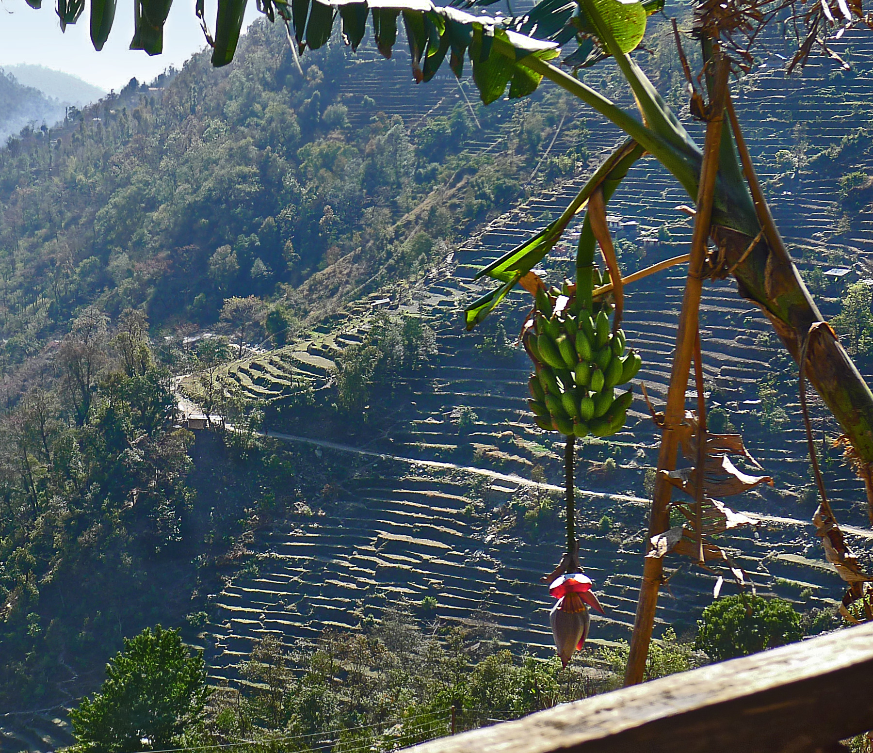
The valleys and lowermost hillsides of Nepal are subtropical; the crops grown there include tea and coffee and these banana trees. If a sturdy trekker were determined to leave the subtropics behind, he or she could walk straight uphill from here into patches of spring snow in a few hours, and into the glacial icefields of the high Himalaya in a few days.
Global warming is spreading up the mountainsides. Nepalis hope they have figured out a way to make money on climate change; the increasing heat in the air that has reduced productivity of tea plantations in India seems to have permitted tea cultivation higher than ever before on Nepalese hillsides. Not all the new plantings have thrived–the air is thinner in the high mountains, and the soil is rocky and poor. But fine tea is coming out of Nepal these days, from slopes about a mile higher than the bananas shown here.
In the long run, of course, tea won't save Nepal. As the glaciers shrivel in the high mountains and a scanty winter snowpack produces less and less spring runoff for the rivers of the subcontinent, people will have a hard time growing much of anything. Huge thirsty cities downstream are already beginning to compete for water with peasants struggling to irrigate the tiny terraces they have clawed into the mountainsides of Nepal.
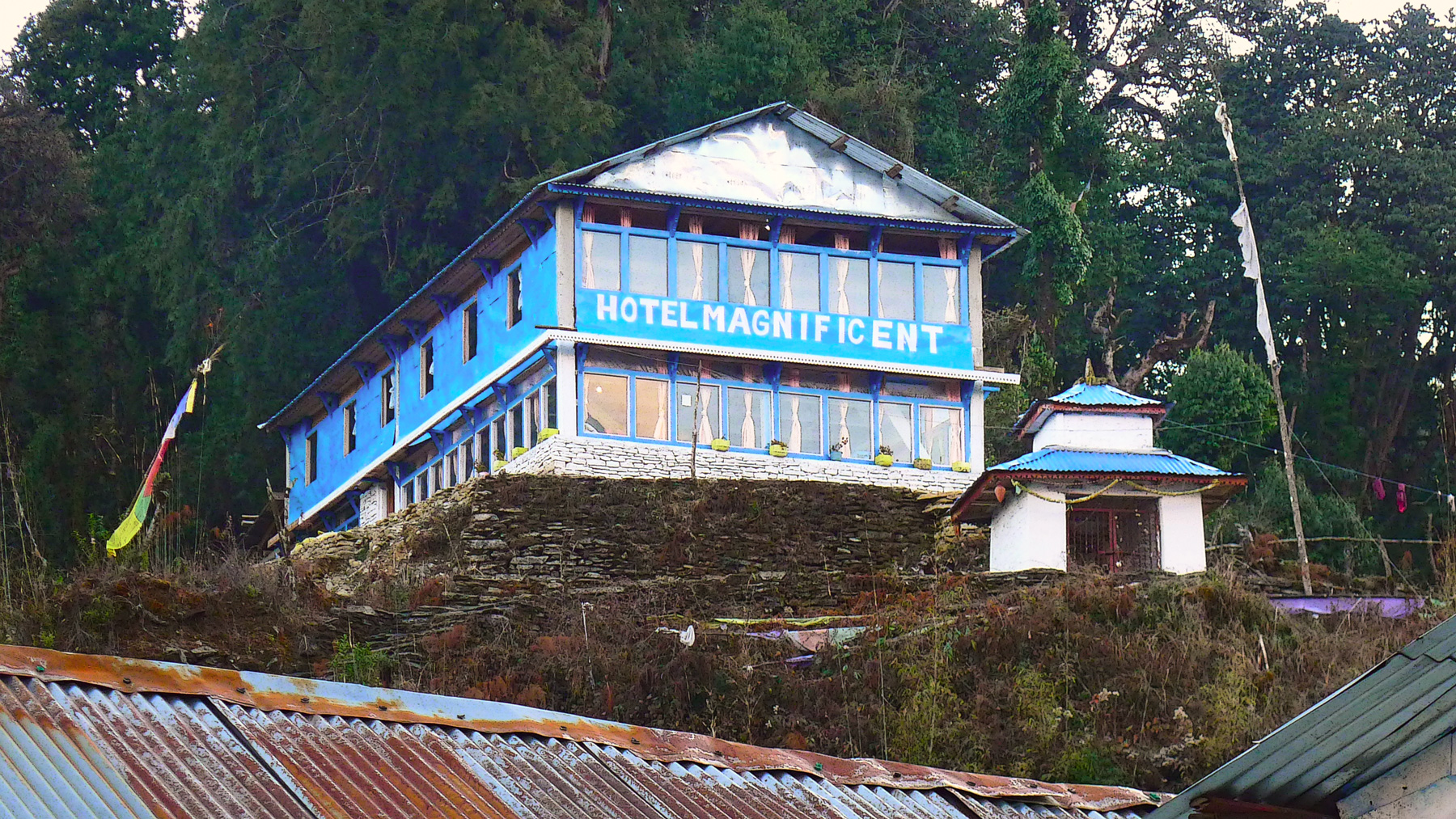
Very soon, if you go to Nepal, to the village of Ghandruk, you may be able to arrange to stay in this new inn, the Hotel Magnificent. It was almost complete, as you can see, when we were there this past March.
I have not been inside the Magnificent, but I can tell you what it is like because all the trekking hotels in the Annapurna region of Nepal are very nearly identical.
The rooms are cubicles separated from one another by partitions of particle board, sometimes unpainted, sometimes covered by a single coat of paint that has been so watered down you can read the ISO number stamped on the particle board right through the color. The beds are thin mats laid on wooden shelves--magnificently comfortable after a day on the trail.
There is a single lightbulb in the ceiling, and no other electrical outlets. Western tourists, of course, have brought along various electronic thingamajigs that need to be charged, but there's no way to take care of that in the bedrooms (unless you have invested in a kind of adapter we heard about, which screws into a light socket so your precious whatever could recharge itself while dangling down from the ceiling, and while you sit in the dark waiting to put the lightbulb back in its socket . . . ). Sometimes the people running the hotel will let you charge your stuff in the dining room, for a fee.
Also in your room is a window with a magnificent view.
There is a bathroom with a kind of fixture that is basically a hole in the floor There may be a sink for washing your face, either in the hallway or outside in a courtyard. Out back somewhere may or may not be a shed with a cold water shower. The water tap in the shower is labeled "USELESS;" we eventually figured out that the label was actually a directive to "USE LESS."
There is a restaurant, usually outdoors on a deck. The food is heavy and filling. Nepalis never order anything on the menu; they eat lentils for every meal.
There is no heat in the rooms. This was not a problem, since the porters had brought along our bags containing fleeces and coats and hats and gloves.
Some of the dining rooms are heated by a bucket of coals placed underneath the table. Blankets are pinned around the sides of the table, hanging down to the floor to keep the heat in. Stick your feet under the blanket. Scrunch up that blanket so your knees also are in the warmth. Magnificent.
One restaurant had a big woodstove in the middle, surrounded by a wooden railing. Nepalis pulled up benches so they could sit leaning forward, arms resting on the railing, holding mugs of steaming tea. Westerners wearing heavy coats sat at dining tables far off in the cold reaches of the room, near the windows, drinking lukewarm tea and talking about the magnificent view.
The new Hotel Magnificent is many hours' walk uphill from the nearest road. All the bricks, all the particle board, the tin for the roof, the buckets of blue paint–everything had to be carried uphill–up thousands of rock steps–strapped onto the backs of donkeys or humans.
And they only charge $2 or $3 a night. Pretty magnificent.
One of the masterworks of early American art, Asher B. Durand's massive 1853 oil painting "Progress (The Advance of Civilization)," has been sold privately to an unknown buyer, perhaps Bill Gates, and has disappeared from public view after almost half a century on display in Tuscaloosa, Alabama. The sale price may have been in the range of $50 million.
The details of the painting, which are very difficult to make out in this digital reproduction, utilize landscape to represent time. There is wilderness in the foreground, where Indians stand on the rocks looking way off into the distance. The middle distance is pastoral: fields of grain, country roads, a horse-drawn wagon. Far off in the background is a new railroad trestle and a train, its engine belching smoke. The Indians are still standing in the forest primeval, but already, they and their paradise are so last week.
I remember writing a paper on this kind of symbolism in college, as did a million other students. It all has something to do with a new American way of looking at nature: Old World artists painted romantic landscapes in which the ruined stones of ancient buildings were being reclaimed by the forest, whereas in American landscapes, fresh civilization was intruding into nature. Either way, the story was somehow sad.
The story of what happened to the Durand painting this year is also sad, and the lesson it illustrates could be taken to implicate both nature and civilization: i.e., human nature.
About fifty years ago, Jonathan "Jack" Warner, the wealthy owner of Gulf States Paper Company in Alabama, started collecting art, mostly American art. He bought original Audubon prints and put them up in the company cafeteria. He bought paintings by Winslow Homer, Georgia O'Keefe, Andrew Wyeth, Edward Hopper, Mary Cassatt, James Whistler, Edward Bierstadt, Gilbert Stuart, and dozens of others; he kept many of the paintings at home but decorated the walls of corporate headquarters with many others. Eventually, he built a museum for the collection.
The museum was open to the public, but it was still a private collection, funded in large measure with corporate money. Warner had a good eye for art and also apparently a good nose for a bargain, and eventually the art collection came to represent many tens of millions of dollars of corporate assets. He set up a foundation to manage the collection, but ownership remained substantially with the company.
And he turned over corporate leadership to his son. "That was a huge mistake," he said recently. "I think about that every day."
Warner's son, Jonathan "Jon" Warner, remade the family business, changing its name to Westervelt Company, selling off its paper mill and focusing on forest management and renewable energy. Early this year, plans were announced to build a plant in west Alabama to manufacture wood pellets for export to Germany.
Building the wood-pellet plant will cost about $50 million. The Durand painting may have fetched that much, even in the somewhat depressed art market that has lingered since the financial crisis and recession.
In fact, the recession has made the painting much more valuable to a corporate entity like Westervelt. One of the provisions of the 2010 Stimulus Act provided for a one-year capital-gains tax break for companies selling assets not related to their core business.
The Warner collection curators say they came in to the museum one Monday morning and found blank spots on the wall where many of the paintings had been. Westervelt's board of directors had voted to sell the art.
Jack Warner did manage to keep a large part of his collection intact, and he has created an organization called the Tuscaloosa Museum of Art to eventually display it. In the meantime, several dozen of the paintings make up a traveling show that has been exhibited in London and is now at the University of Pennsylvania's Ross Gallery in Philadelphia.
Speculation as to the buyer of "Progress" has focused on two deep-pocket collectors who are known to be interested in American art: Alice Walton, of the Wal-Mart fortune, and Bill Gates. Jack Warner's wife personally called Ms. Walton and was told that no, she did not buy the picture. It has also been reported that Gates has denied the purchase, but some sources say that he always issues denials and that it is exactly the kind of painting he would want.
On June 30, 2011, rhe cloud at the righthand side of the sky in this picture cast a big shadow over the West Arm of Grand Traverse Bay, near Traverse City, Michigan. That's because the sun had already set, and its last rays were hitting the cloud from a very low angle, well below the horizon.
The top of the shadow looks curved, I'm told, because of the extremely wide angle of vision here. It's a perspective thing–we think of the horizon line off in the distance as a straight line, but in a wide-angled scene like this we can see that it's actually a curved arc. For a few minutes, the shadow darkens a wedge of the celestial sphere; then this part of the world turns away and the scene is in serious earth shadow, not just cloud shadow, till morning.
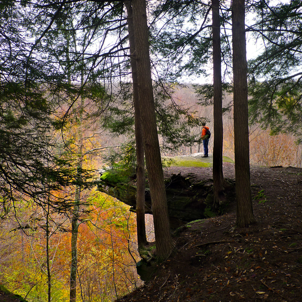
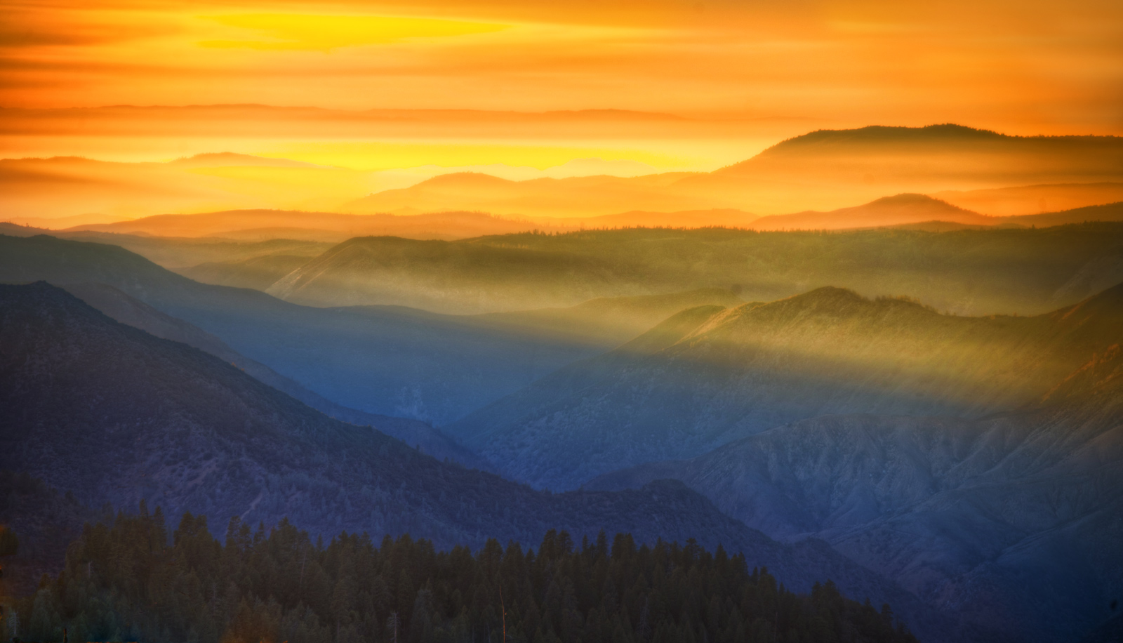
Appropriately enough, what you can see from the top of Castle Rock, just outside World's End State Park in the Endless Mountains of Sullivan County, Pennsylvania, are endless trees and endless mountains. Way down below is a tributary of Loyalsock Creek, which spills heedlessly over waterfall after waterfall en route to the west fork of the Susquehanna.
It is definitely the time of year to wear bright orange in these woods.
On a crisp October Saturday, deep in the Loyalsock Canyon of World's End State Park, you have to wait on line for your turn to take pictures of the waterfalls.
Ordinarily, creeks and waterfalls have shriveled to a trivial trickle by this time of year. But after a wet, wet summer and then the floods of Hurricane Irene, waterways throughout Pennsylvania are putting on a show.
Our neighbor Carolyn Duffy poses for a snapshot along Wissahickon Creek in Philadelphia's Fairmount Park, with her dogs Max and Toby. The big dog, Max, must really like Fairmount Park because he is notorious for making all the decisions with respect to where they'll go on walks and how long they'll stay out. He weighs well over a hundred pounds, and if he doesn't want to go somewhere, it's probably just as well if you don't bother trying to go there.
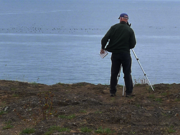
He had driven a thousand miles for the chance to set up his scope at Deception Pass, on Puget Sound about an hour north of Seattle. But the notebook in his left hand received no new entries; he saw birds, to be sure, but he'd seen them all before. The only thing he saw that day of even mild ornithological interest was the long line of black dots way out at sea–they were grebes, he told us, a very common waterbird, but a kind that didn't usually flock together so massively; there were hundreds of grebes out there on the tide, he estimated, bobbing and diving, more by far than he'd ever seen in one place before.
The Audubon Society reports that grebes are pretty standard inhabitants of Deception Pass and thereabouts, along with mergansers, cormorants, black oystercatchers, alcids, and common and Pacific loons. But the big ornithological draw, especially in the wintertime, is the red-throated loon. Maybe this birdwatcher will schedule another trip when the weather is a whole lot worse.
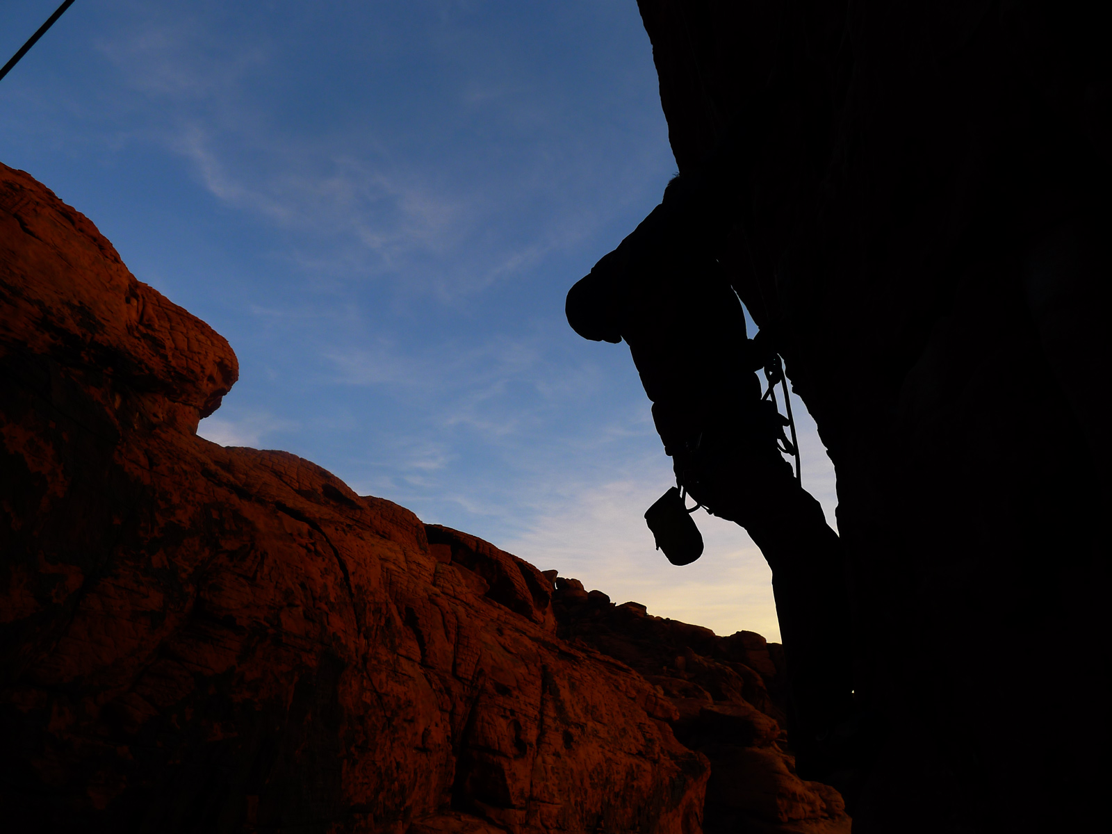
Bunch a guys were off climbing last week in Red Rock Canyon, a few miles west of Las Vegas, Nevada. Here, Hank leads the route, carefully placing little thingamajigs in cracks to hold the rope so other climbers can follow him safely. As lead climber, Hank is roped in, but not quite as safely as the followers; if he loses his grip on the rock, the thingamabobs below him should arrest his fall (with the help of the belayer down on the ground), but before they do, he could expect to fall twice the distance down to the topmost thingamabob. He didn't fall.
The red rock here is the Aztec Sandstone formation, Jurassic in age. Overlaying it in much of the canyon is a dark gray limestone, the much, much older Bonanza King limestone, from the Cambrian era. The older limestone got shoved up on top of the younger sandstone late in the era of the dinosaurs, when tectonic plates were compressing this part of the world, pushing up mountain ranges.
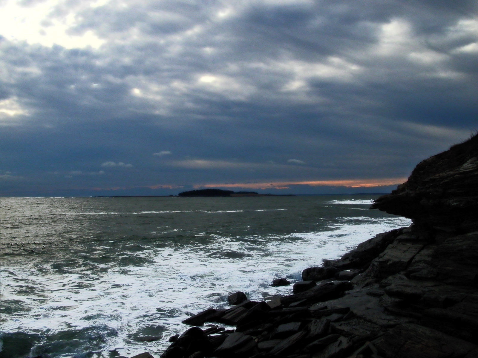
Two winters ago around this time, when this picture was snapped, there was no snow along the southwest coast of Maine, though somehow the color of the water suggested some seriously shivery cold. This year, I understand that there's a bit of snow on the ground in Maine; here in Philadelphia, however, we've had only a flurry or two. It's raining as I type.
This stretch of cliff near Kettle Cove in Cape Elizabeth, Maine, faces south more than east, allowing a glimpse of winter sunset over the water.
Terlingua encompasses thousands of acres of sparsely settled desert country along the Rio Grande in far west Texas, between Big Bend National Park and Big Bend State Park. There's cinnabar ore in those mountains, enough to support profitable mercury mines a hundred years ago, but nowadays the only mercury miners left are the ones in the Terlingua cemetery.
Many of today's Terlinguans live more or less off the grid; land is inexpensive, but bringing in electricity costs something like $10,000 per pole. The landowners are only lightly supervised by local government, but like big-city condo owners they are regulated by an owners' association, which employs a full-time staff to maintain community wells and roads and to operate an income-generating campground and lodge.
Vanessa Boyd, director of the landowners' organization, which is known as Terlingua Ranch, is a musician as well as a land manager. She just released a new album last week, which incorporates songs she composed in preparation for a 2010 concert tour to Nepal.
Out of deference to the Oscar thing, today's g'mornin features an image by a photographer best known as a filmmaker, Turkey's Nuri Bilge Ceylan. The panorama here shows part of a twenty-four-hundred year-old site in eastern Turkey dedicated to Nymphaios, the Greek god of rivers. For another example of Ceylan's still photography, see here.
Of the various dogs who've come to live with us over the years, only one–this one–was named Professor Brophy. We called her Professor for short. Professor was a dumpy-looking brown dog from the pound with big jaws and an unfortunate personality, to put it mildly; she snarled at people when they tried to come in the house and then snapped at their heels when they tried to leave.
You may ask why we invited such a beast into the family. Well, obviously, Professor was smart enough not to treat us as rudely as she treated outsiders. Maybe she did what she did because she cared for us and felt she had to protect us from dangerous intruders. Or maybe she really despised us right along with everybody else but realized she'd better suck up to us.
Whatever was going on in that professorial little dog brain, it kept us hopeful for a while. And mixed in with the trying times were some very, very nice days with Professor–such as this perfect summer afternoon up above treeline on Mount Washington. That's Professor Stein following along behind as Professor Brophy breaks trail; a good time was had by both.
"Somewhere in Transylvania," according to the photographer, who offers up only two facts about himself by way of identification: he lives in the city of Arad in western Romania, and he likes Johnny Cash and Frank Sinatra.
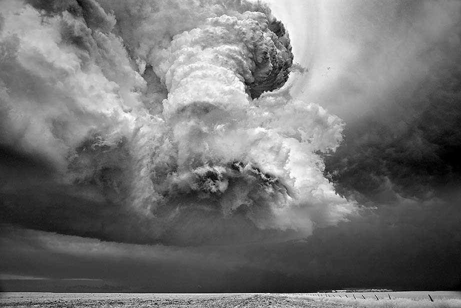
On a day in 2009 when Zeus and Aeolus and everybody else up there must have gotten up on the wrong side of the bed, Mitch Dobrowner photographed these clouds over Galatia, Kansas.
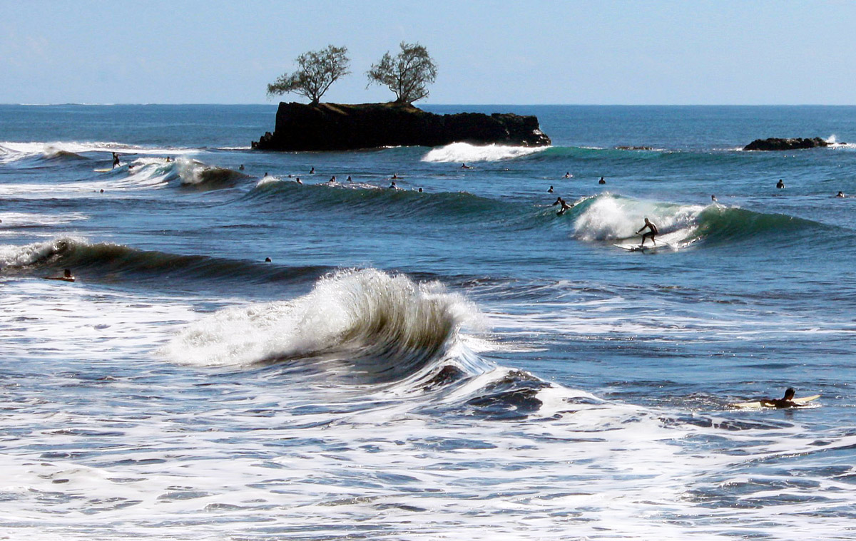
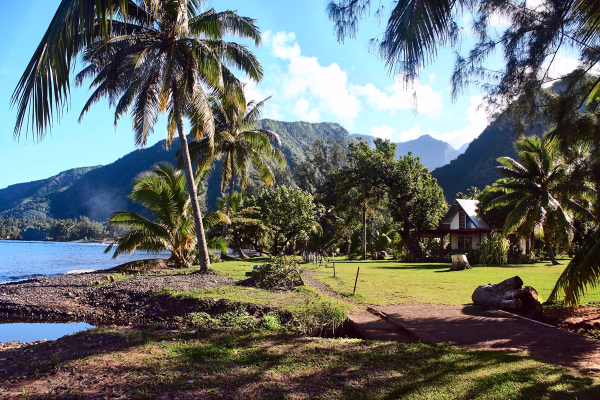
"I send you two pictures of Tahiti," writes my brother, Chuck-the-nuclear-astrophysicist. "Captain Cook was sent to Tahiti to observe the 1769 transit of Venus (Venus passing in front of the sun). He then had secret orders to search for Australia, which he found. I saw the 2012 transit from Point Venus, a beautiful sandy beach on the northwest corner of the Island, where Captain Cook observed the 1769 transit. It was a magical festival with lots of natives.
"The surfing scene is from the north side of the island not far from Point Venus, while the other picture is from the opposite side of the island, on the south side of the Tahiti Iti peninsula, where the road ends."
Chuck spent a week in Tahiti, doing his scientific thing, and then he had to fly back home so he could get ready for a conference in Italy. It's a tough life, nuclear astrophysics, but somebody's got to do it.
This picture needs something to suggest the scale of what we're looking at in the University of Alaska botanical garden in Fairbanks. The person in the background isn't really close enough to the cabbage that's the center of attention here. But perhaps, if you know about those Alaska cabbages that top out at 50 or 100 pounds or suchlike, inspired by sunshine 24 hours a day, then you can freely imagine the scale and be appropriately impressed. (Hint: Think Little Shop of Horrors.)
Giant hogweed has spread from the Caucusus region of Russia across central and northern Europe and now across the northern United States and Canada. It's an invasive species that takes over roadsides and the edges of pastures and creekbanks. You don't want it near you.
It doesn't look so bad. It's got big, toothy leaves that green up very early in the spring around a central stalk that can grow ten or twelve feet tall, topped by lacy white flowers. But it's a terrible neighbor, full of bad habits. Even its early spring growth is problematic, because its leaves shade the ground all around, stunting or killing the native grasses and other plants. If it spreads to a creek or riverbank, its shallow root system can lead to rapid and severe erosion.
Cows don't like the taste of it, and that's a good thing for the cows. People, on the other hand, don't know to stay away. They might brush up against it as they are walking by. They might even pick the flowers. Children have been known to use the stems as pea shooters. None of this is a good idea.
Giant hogweed produces chemicals that make skin extremely sensitive to sunlight. If you touch any part of the plant and then stay out in the sun, you will wake up the next morning with severe, blistering sunburn. If the hogweed touched the eyes or mouth, the resulting burns can cause permanent tissue damage, even blindness. Fatalities have occurred.
As shown above, giant hogweed eradication efforts can involve serious herbicides and hazmat suits. Some infestations are best countered with a herd of goats; goats eat the weeds happily, especially in early spring when the leaves are still tender and small. In either case, the hogweed will grow back and must be attacked repeatedly for at least a couple of years.
The Romans found gold here at Dolaucothi in south Wales, near the village of Pumsaint, in 74 A.D. During five centuries of mining, Roman engineers developed hydraulic works, then a large open pit mine, and eventually vast underground operations, complete with dewatering channels and pumps to keep deep mine tunnels from flooding.
Beginning in the nineteenth century, the British made several tries at reopening the mine, but they gave it up for good in 1938, defeated not so much by lack of gold as by surfeit of water underground. Today, Dolaucothi is a national park, offering mine tours and archaeological exhibits of Roman artifacts found onsite.
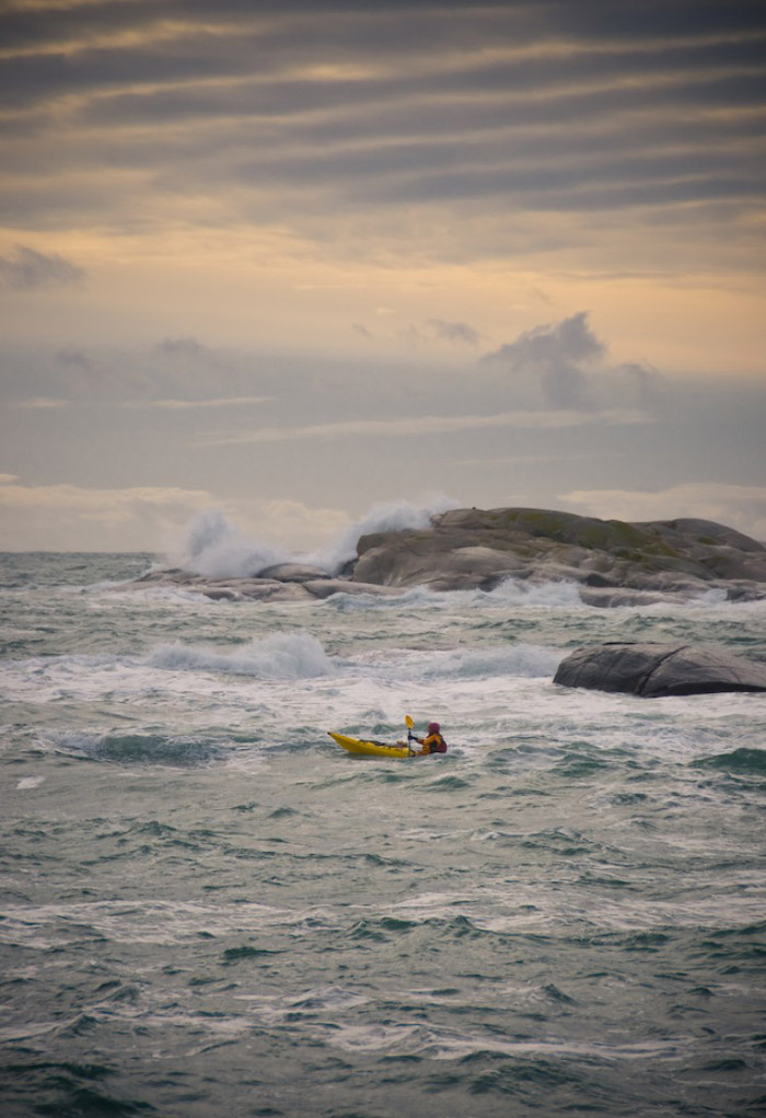
World's End is the name of a state park in Pennsylvania, a knob in the marshland near Boston, an off-the-map locale for the weakest sequel to Pirates of the Caribbean, and a major site of action for World of Warcraft. But the World's End that this kayaker is nearing is the southern end of Tjøme Island, near the outlet of Norway's Oslo Fjord.
The only summer in American history drier than this summer of 2012 was 1936, the time of the Dust Bowl. In South Dakota, home to the family of Vernon Evans, pictured here, the drought was compounded by a grasshopper plague. The crop failed, the bank took the farm, and there were no jobs to be had. "You couldn't even buy a job," according to Evans.
They had $54, and no idea how they were going to get by, when they piled into their Model T and headed west. The first day they only made six miles before breaking the crankshaft; fortunately, a nearby farmer had a yard full of dead Model Ts; he told the Evanses to find themselves a crankshaft and take it, no charge.
They were on the road again a day later and made good time for the next few days, averaging about 200 miles a day till they reached the outskirts of Missoula, Montana, where they passed a car at the side of the road with a man sleeping in it. They honked at him, "just having a good time." The man woke up quickly, started his car, and chased them down, waving frantically for them to pull over. They thought he was a cop turning them away from Missoula; many communities had posted guards to try to keep the Dust Bowl migrants out of town.
"Well, here's where we go back home," the Evanses said to one another. They had $16 left.
But the cop turned out to be Resettlement Administration photographer Arthur Rothstein, who introduced himself, explained that the sign on the back of their car had caught his eye, and asked if he could take a picture. They told him they were headed for Yakima, Washington, hoping to arrive in time to find work harvesting hops.
Rothstein snapped eight poses there on the road to Missoula, which the family recalled seeing in newspapers and magazines a few months later, when they were newly settled in Oregon, working for the railroad.
Among the finalists for this year's National Geographic photo competition is this shot of a baobab grove near the town of Morondava in western Madagascar.
Baobabs are unusual trees, with swollen trunks that store water, allowing them to survive long periods of drought. Some species of baobab can grow without soil, drilling their roots directly into bare limestone, and some are so tolerant of salt water they can grow within a few feet of the ocean.
The trees in this picture are believed to be many thousands of years old, but baobab wood does not produce annual growth rings, making age calculations rather speculative.
Baobabs produce fruit with a flavor that is described as very tart and grapefruit-like. The fruit pulp is a common ingredient in many regional dishes and is being studied by international food companies as a possible additive to Western-style foods and beverages, such as fruit smoothies. "It brings an interesting and exotic flavor," said PhytoTrade spokesperson Lucy Welford. "Now that we've had a lot of interest in Europe, I think there might be a knock-on effect in the U.S."
There are good things to say about summertime, but there's also this: it was too damn hot. The air finally feels fresh and pleasant at this new-beginning time of year, even if I've had the same song in my head now for forty-one Septembers. . . .
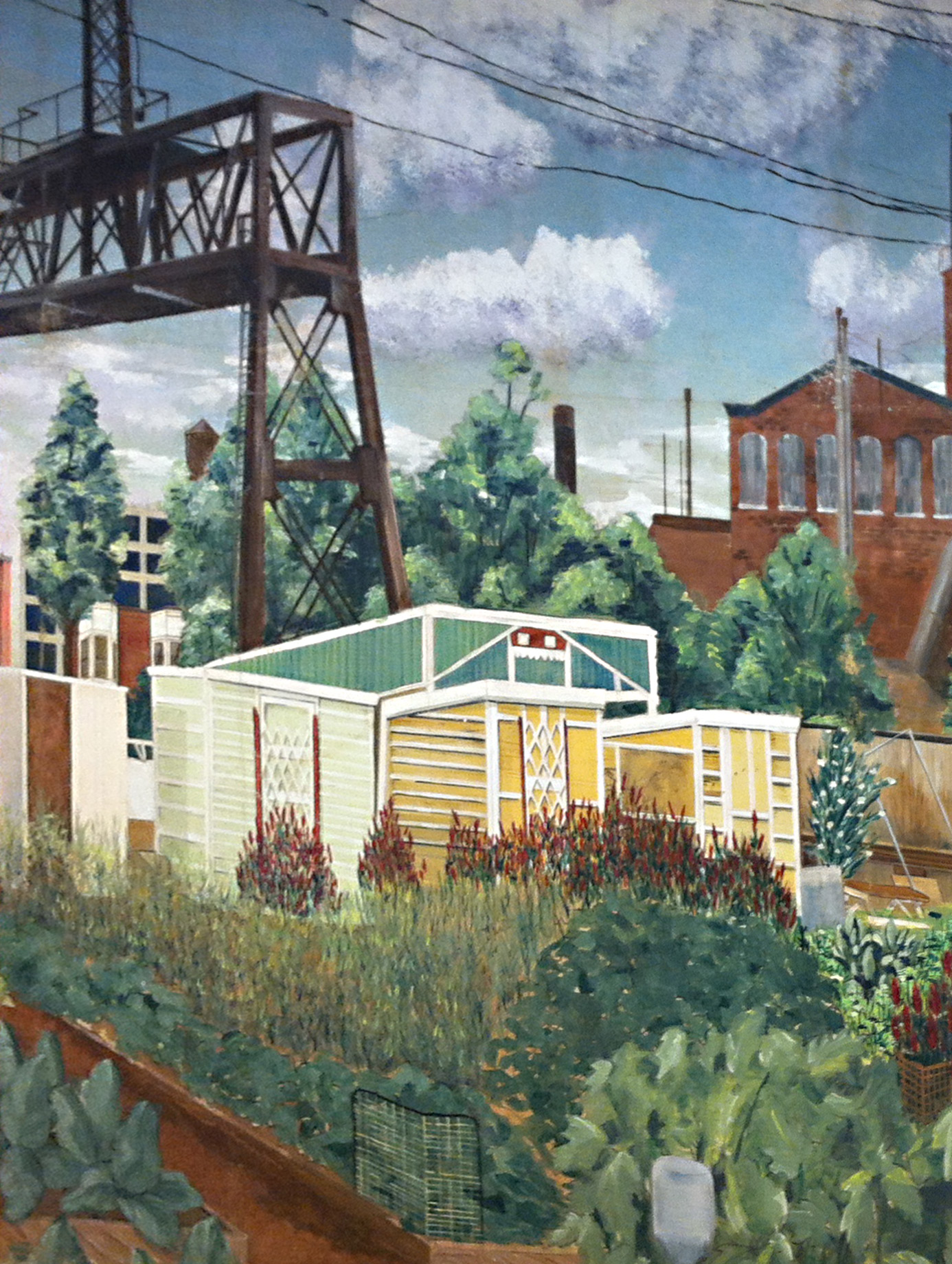
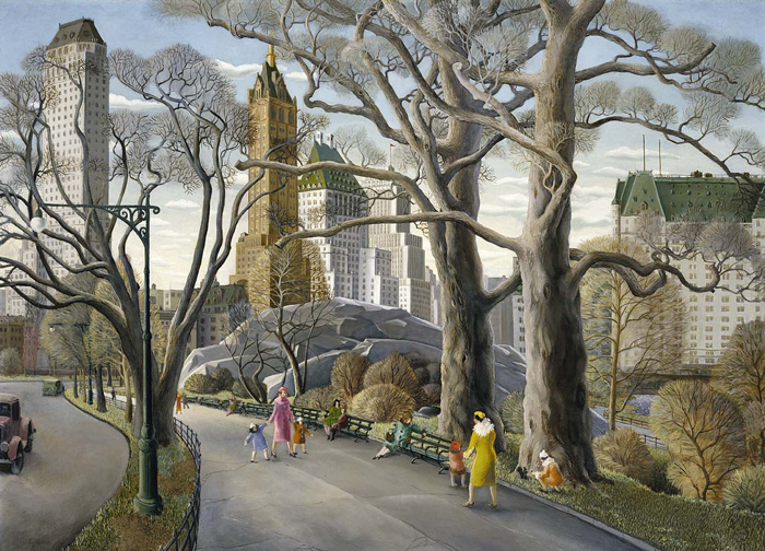
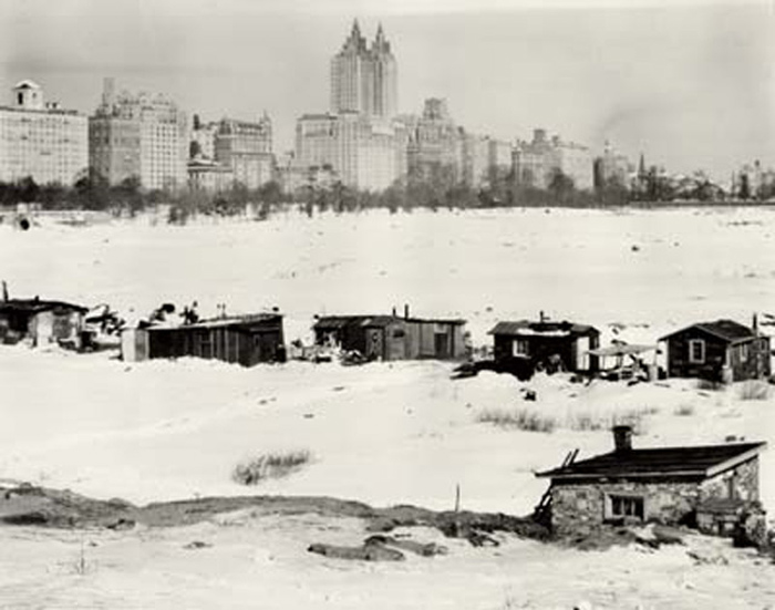
In 1934, Carl Gustaf Nelson painted life in New York's Central Park, above, the way life ought to be; in 1932 and 1933, photographers from the New York Daily News aimed their cameras at Central Park's Hooverville, below, revealing life that was not being lived the way people ought to live. Both images tell something of the story, in an upstairs-downstairs sort of way.
New York's homeless citizens began building shanties in Central Park's Sheep Meadow late in 1931, by which time half the factories in the city had been shut down by the Depression and literally millions of New Yorkers were desperate for food and shelter. In 1930 and 1931 homeless people tried to camp in Central Park, but they were repeatedly arrested for vagrancy; as the economic situation became more and more dire, however, policemen and judges became more sympathetic to the "bums," and official eyes were averted as this and many other Hoovervilles emerged. Some of the shacks were said to be solid brick and stone houses with tile roofs, built by unemployed bricklayers.
The residents of Central Park's Hooverville said they had built their homes along Depression Street. Many of the shanties had furniture and at least one had carpets, but there was no electricity or running water, no sanitary facilities at all. In 1933, the city condemned the dwellings, evicted the residents, and demolished the shantytown. The official justification was public health.
Thus, by 1934, when Nelson painted his picture, Central Park had been officially reclaimed for the sole use of well-dressed, well-to-do people like the ones in the painting, people with warm apartments to go home to and indoor plumbing. The people of Hooverville had moved on, and they would keep on moving on, scraping by, somehow, till a government stimulus program, aka World War II, finally brought full employment back to America.
More than four millennia ago, people who called themselves Sicels built a town atop this hill, 300 meters above small streams in the steep-sided limestone valleys of southern Sicily.
Then came the Greeks and briefly the Carthaginians, then the Romans, the Byzantines, the Arabs, and finally, in the eleventh century, the Normans. The town had its name by then, Ragusa. As part of the Kingdom of Sicily, it slipped out from under control of the Norman duke Geoffrey and became a fief of the Chiaramontes, the most powerful family in Sicily.
At first glance, Ragusa's many centuries, particularly its medieval times, appear plain in the architecture and plan of the town clinging to the hill. But that's an illusion; almost everything here postdates a severe earthquake in 1692, which killed thousands of people and destroyed almost all the buildings, including a very large Gothic cathedral.
What we see today is Ragusa rebuilt, in the early eighteenth century, in the style known as Sicilian baroque. We also see Ragusa stratified; the rich people moved over to the next hill to rebuild their homes and churches–Ragusa Superiore–while the poor stayed where they were, rebuilding in the rubble– Ragusa Inferiore, known today as Ragusa Ibra.
Of the two Ragusas–essentially identical in age and architectural style–the poor folks' town, featured in this photo, attracts more attention from twenty-first-century tourists and is generally considered the more picturesque. The replacement for the ruined cathedral, however, is in Ragusa Superiore.
As an American, I have my doubts about places that look like this; I sniff Walt Disney and/or Hollywood and/or Colonial Williamsburg in the so-called Sicilian air. I fear this is a town populated by characters in costume whose main role in life is to get me to part with my money. But you know what? I'll take the risk. And if I ever get to Sicily . . . I can't promise I'll come back.
The Russian painter Ivan Shishkin was illustrating scenery in Poland in 1890, when he completed this painting of the swampy forests of the Pripyat, or Rokitno, marshland. Today, the spot where he set up his easel could be in Ukraine or Belarus or Russia or perhaps extreme eastern Poland.
But the scene he painted may or may not look much the same. The marshes of Polessia remained lightly settled throughout much of the twentieth century; the forests there provided years of cover for partisans fighting for and against the Nazis and the Soviets.
Then came the Chernobyl nuclear disaster of 1986, which devastated much of the countryside, leaving large stretches radioactive and uninhabitable. Not all the wildlife has returned. Although herons have again been reported, "mushrooms and berries," it is said, "set Geiger counters screaming."
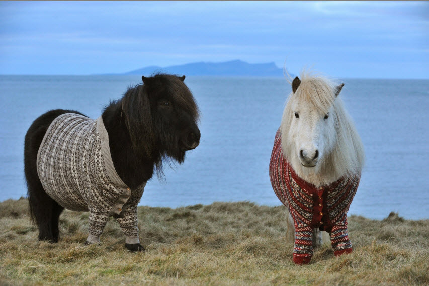
Vitamin, at left in the brown cardigan, and Fivla, at right, wearing red, play starring roles in a new ad campaign urging everyone to visit Scotland in general and the Shetland Islands in particular.
Vitamin and Fivla are classic Shetland ponies, wearing traditionally patterned Fair Isles sweaters custom-knitted by Shetland native Doreen Brown, from yarn spun from the wool of Shetland sheep, and they are posed all warm and cozy on the windswept moor of a scenic Shetland isle, and if this picture doesn't get you to go there then nothing will.
The 2013 photographer of the year for the GDT. a society of German wildlife photographers, is eighteen-year-old Hermann Hirsch, who called his winning shot "Evening Idyll."
Blodgett Canyon, in the Bitterroot Mountains of western Montana, is a Yosemite-esque sort of place, flanked on the north by sheer granite walls of towering spires that are absolutely irresistible to rock climbers with ropes and stuff.
Our boy Hank climbed Blodgett's 600-foot Shoshone peak twice this spring; the first time, a sudden rainstorm forced a rapid rappelling retreat that left a lot of climbing gear stuck in cracks on the rockface. The second climb, pictured here, was a successful gear-retrieval mission–and also a sun-kissed flirtation with warm spring skies.
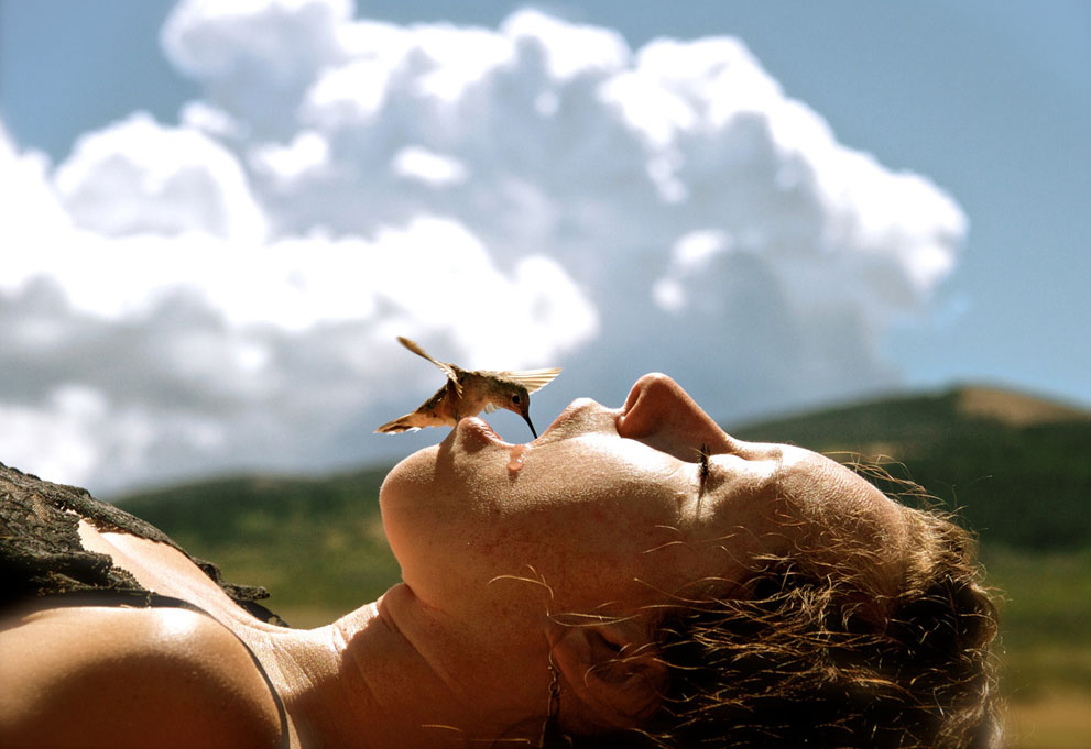
During last year's drought, this hummingbird was photographed drinking from a person's open mouth in Rawlins, Wyoming. The photo has been submitted to National Geographic's 2013 Traveler photo competition, which is accepting entries through the month of June.
Heavy rains in March 2013 broke the three-year drought in the Southeast, but extremely dry conditions persist throughout much of the Midwest and especially the West.
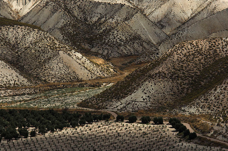
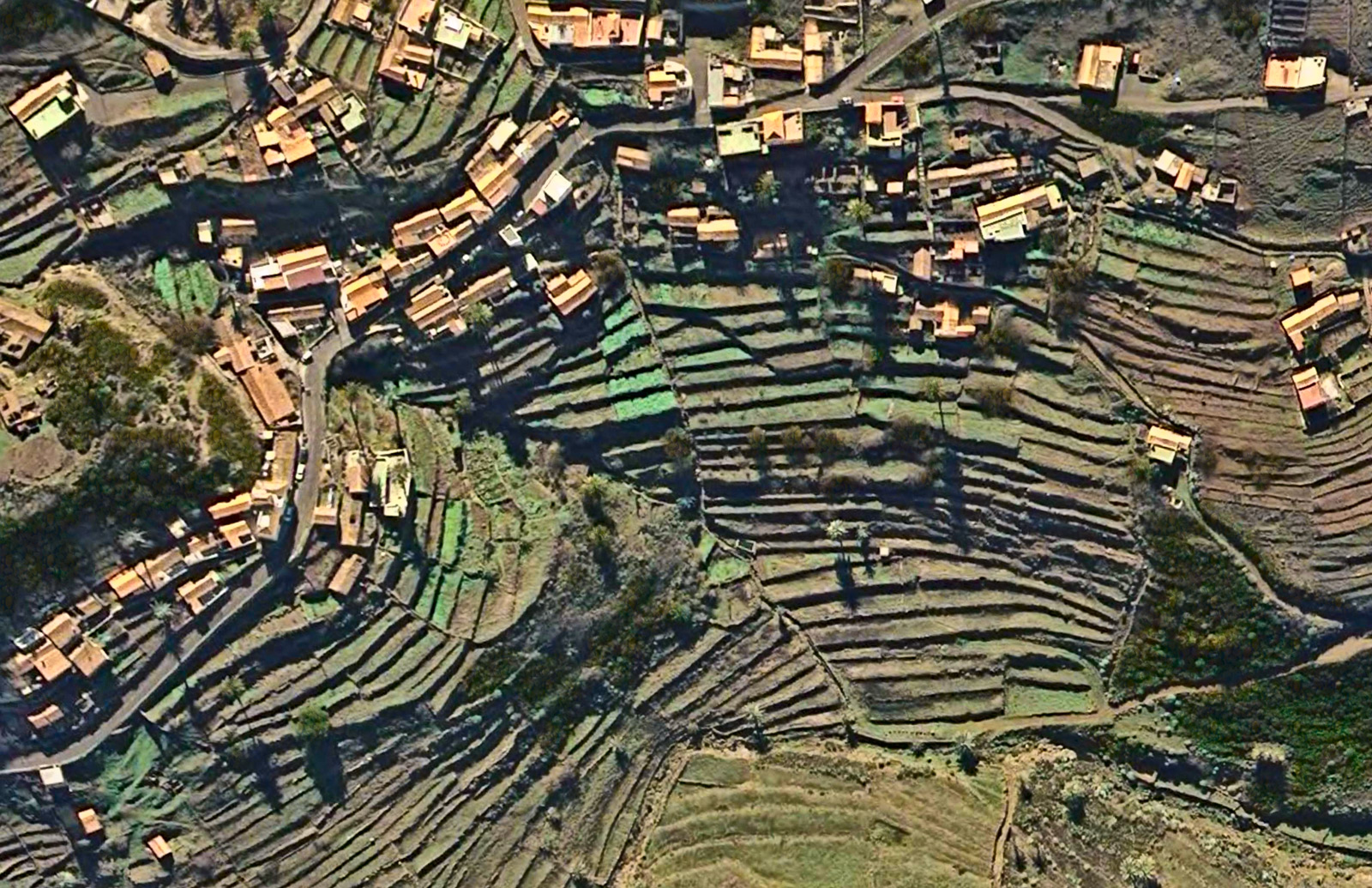
Aerial view of terraced farmland surrounding a village in the Valle Gran Rey on Isla de la Gomera, one of Spain's Canary Islands off the coast of Morocco.
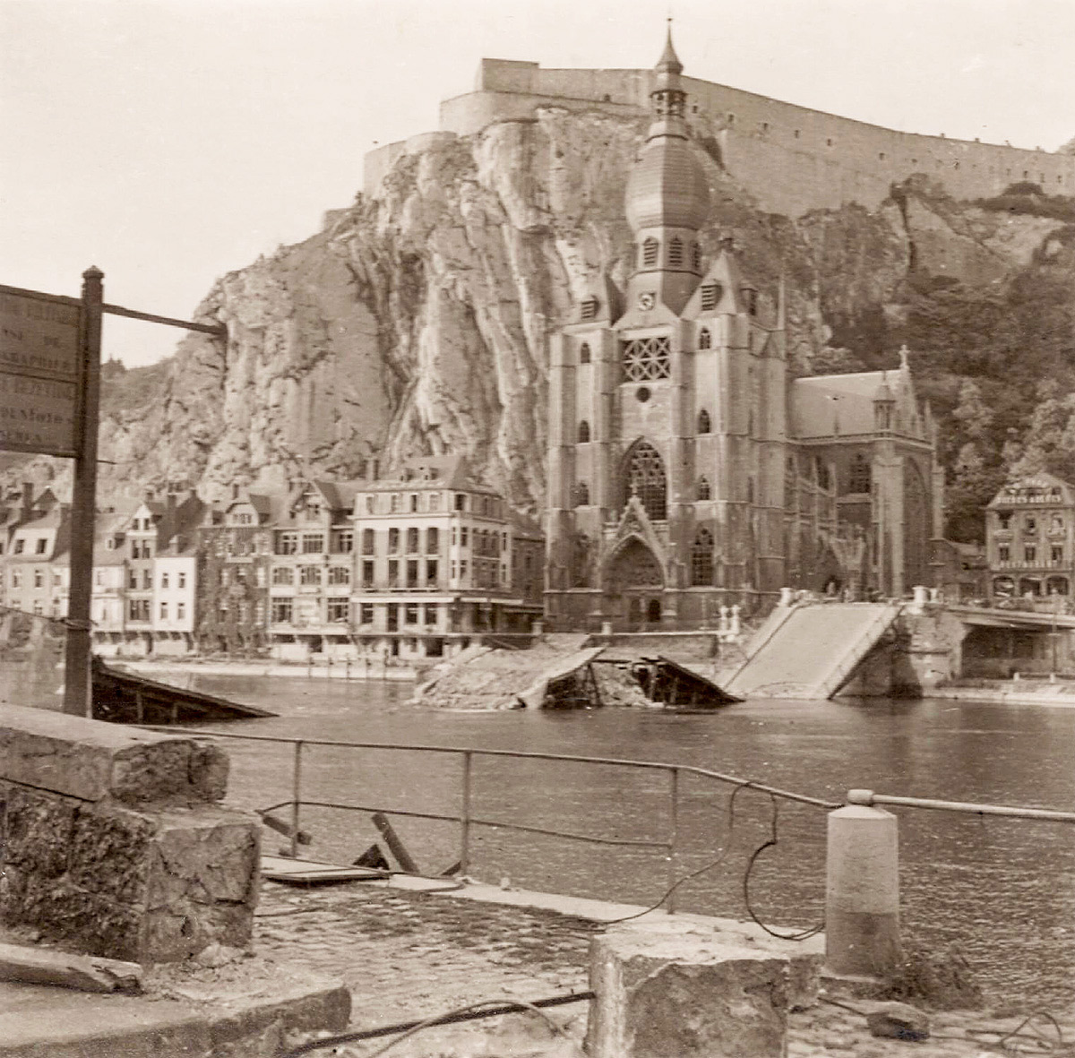
There has been a bridge here over the River Meuse in the Belgian town of Dinant since the twelfth century. In World War I, Charles de Gaulle was wounded during a battle for control of this crossing, but the bridge survived intact. It was destroyed, as shown here, in May 1940, when the retreating Belgian army blew it up behind them; the Germans, however, had already established a pontoon bridge nearby and were not delayed. It was rebuilt in 1950 and named for de Gaulle.
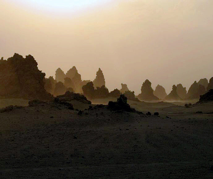
Years of drought have drastically lowered the water level of Lake Abbe, along the border between Djibouti and Ethiopia in the Horn of Africa. Vast stretches of what used to be lake bottom are now exposed, including clusters of limestone formations like these, many of which are chimneys venting sulfuric steam.
The chimneys formed when the vents were underwater; heat from the steam caused minerals to precipitate out of the lake water and build up around the rims of the vents.
Lake Abbe is a salt lake, the lowest point of a desert drainage system that has nowhere to drain. It's full of steam and sulfur because it's probably the birthplace of a new ocean, a triple junction of spreading faults where three tectonic plates are being pulled relentlessly apart from one another. Two of the faults are already so deep that they are full of ocean water: the Red Sea and the Gulf of Aden. The third fault stretches south from Lake Abbe through eastern Africa as a chain of lakes and deep depressions: the East African Rift.
Along these faults, tectonic plates are pulling apart from one another at rates approaching an inch a year, thinning out the earth's crust in the region, and generating much volcanic activity and gaseous emissions. The geologic evidence strongly supports the likelihood that someday the land around Lake Abbe will be thousands of feet underwater, near the middle of a big blue sea.
But it will take a while. Rifting began here about 60 million years ago. At current rates of divergence, the new basin is spreading roughly 10 miles every million years. In another 100 million years, we'll have an ocean about a thousand miles across.
Actually, it's a nesting Falcon. I do not pretend to know what this is all about, except that I understand the bird and almost certainly also the tree are Australian.
Go ahead. Laugh, all you kookaburras. Gay your life must be.
 The valleys and lowermost hillsides of Nepal are subtropical; the crops grown there include tea and coffee and these banana trees. If a sturdy trekker were determined to leave the subtropics behind, he or she could walk straight uphill from here into patches of spring snow in a few hours, and into the glacial icefields of the high Himalaya in a few days.
 One of the masterworks of early American art, Asher B. Durand's massive 1853 oil painting "Progress (The Advance of Civilization)," has been sold privately to an unknown buyer, perhaps Bill Gates, and has disappeared from public view after almost half a century on display in Tuscaloosa, Alabama. The sale price may have been in the range of $50 million.
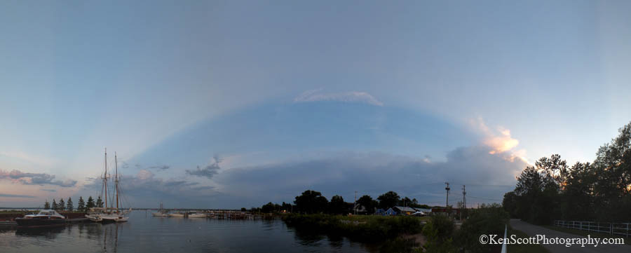
 This land is your land, this land is my land. From California, to the New York Island.


 He had driven a thousand miles for the chance to set up his scope at Deception Pass, on Puget Sound about an hour north of Seattle. But the notebook in his left hand received no new entries; he saw birds, to be sure, but he'd seen them all before. The only thing he saw that day of even mild ornithological interest was the long line of black dots way out at sea–they were grebes, he told us, a very common waterbird, but a kind that didn't usually flock together so massively; there were hundreds of grebes out there on the tide, he estimated, bobbing and diving, more by far than he'd ever seen in one place before.
 High-voltage power lines in central Scotland.
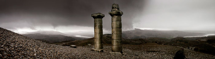 Out of deference to the Oscar thing, today's g'mornin features an image by a photographer best known as a filmmaker, Turkey's Nuri Bilge Ceylan. The panorama here shows part of a twenty-four-hundred year-old site in eastern Turkey dedicated to Nymphaios, the Greek god of rivers. For another example of Ceylan's still photography,


 This picture needs something to suggest the scale of what we're looking at in the University of Alaska botanical garden in Fairbanks. The person in the background isn't really close enough to the cabbage that's the center of attention here. But perhaps, if you know about those Alaska cabbages that top out at 50 or 100 pounds or suchlike, inspired by sunshine 24 hours a day, then you can freely imagine the scale and be appropriately impressed. (Hint: Think Little Shop of Horrors.)
 Giant hogweed has spread from the Caucusus region of Russia across central and northern Europe and now across the northern United States and Canada. It's an invasive species that takes over roadsides and the edges of pastures and creekbanks. You don't want it near you.
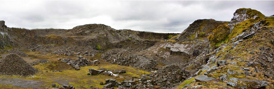

 World's End is the name of
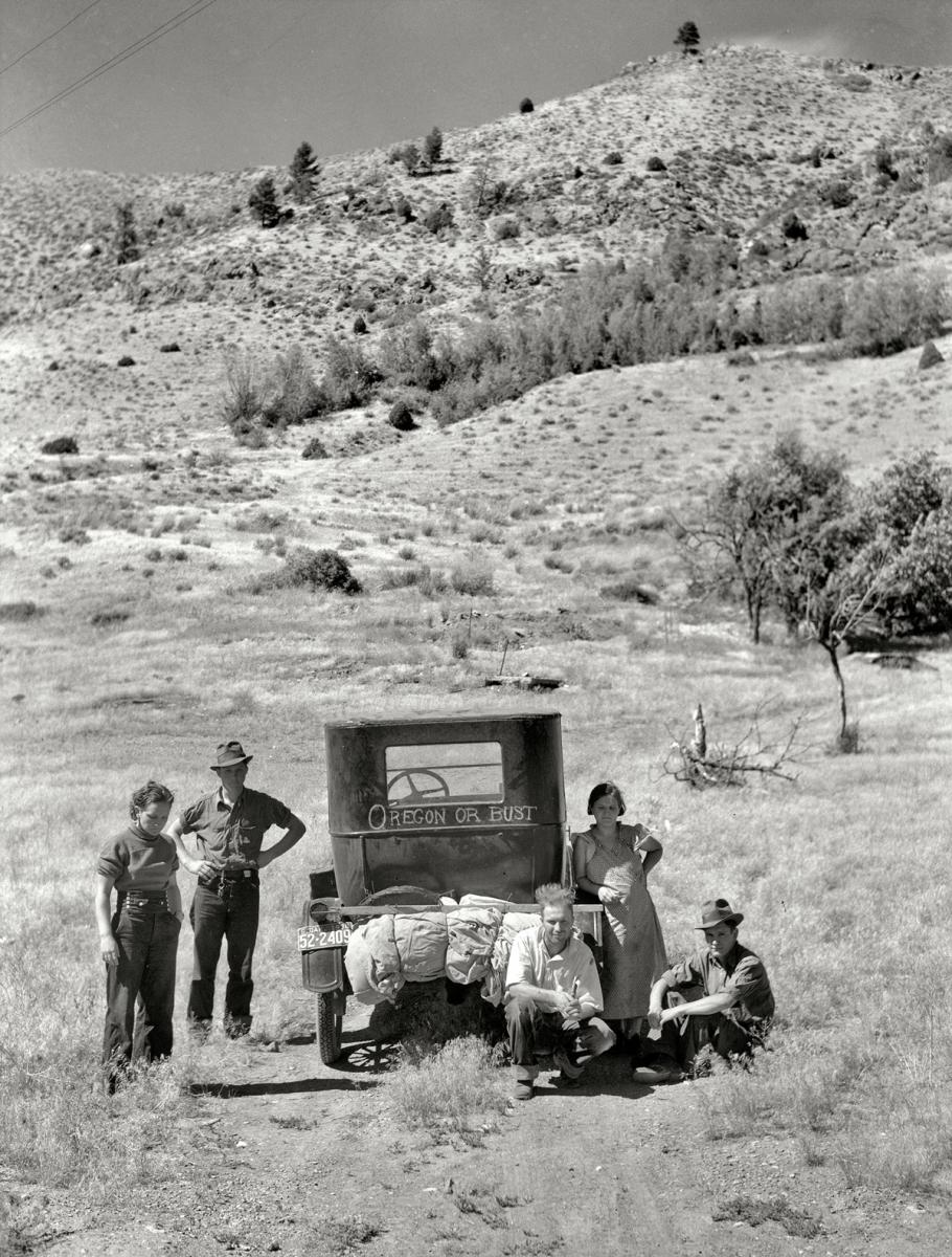

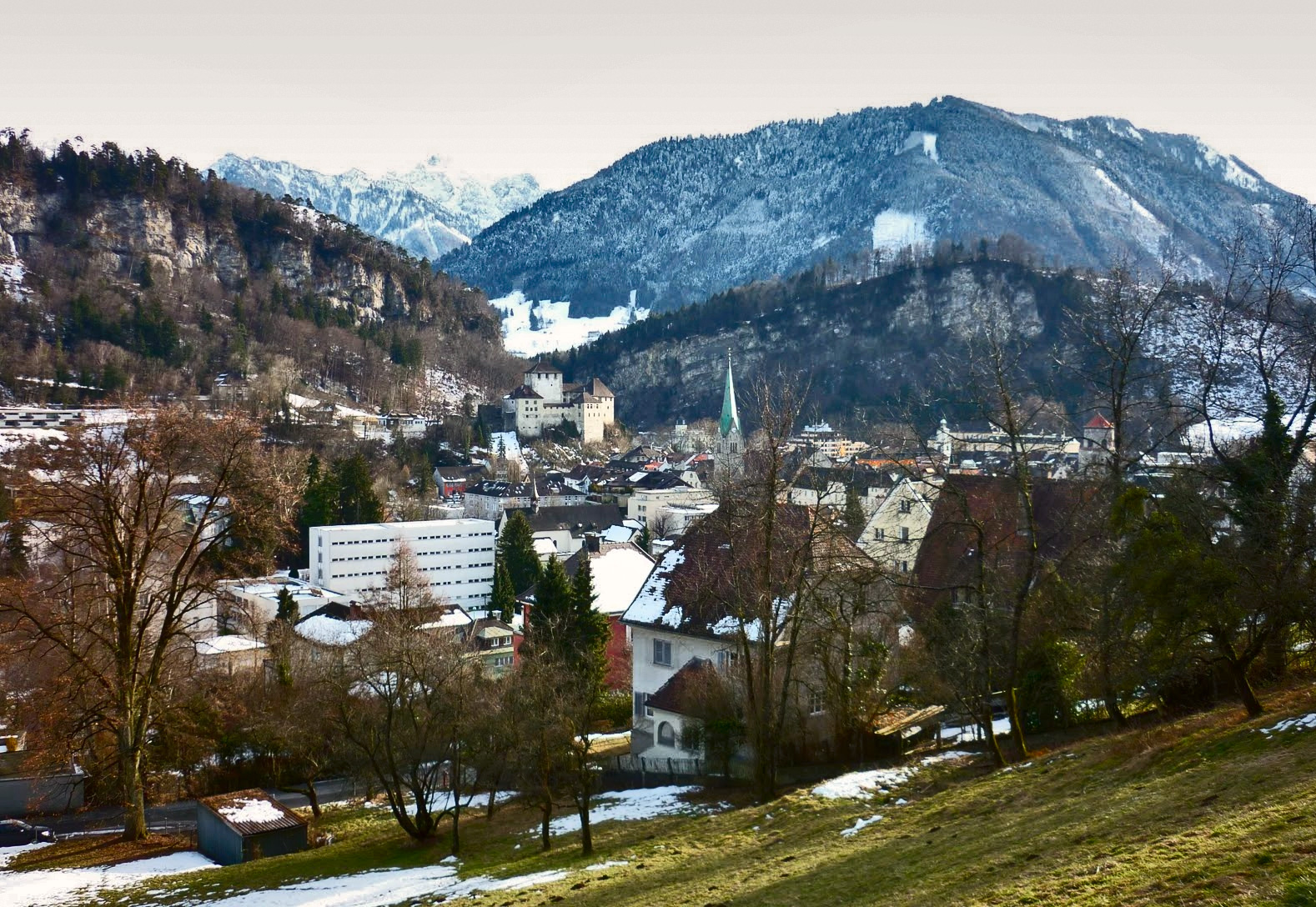
 For those who've been wondering: this is what the landscape looks like in extreme northern Paraguay, near the Brazilian border.

 In 1934, Carl Gustaf Nelson painted life in New York's Central Park, above, the way life ought to be; in 1932 and 1933, photographers from the New York Daily News aimed their cameras at Central Park's Hooverville, below, revealing life that was not being lived the way people ought to live. Both images tell something of the story, in an upstairs-downstairs sort of way.
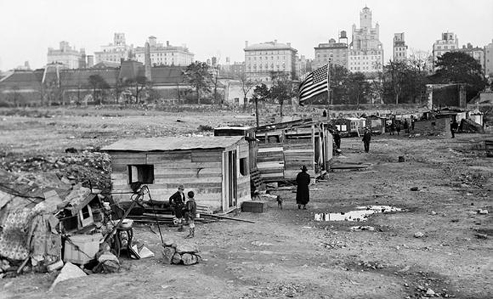


 The 2013 photographer of the year for the GDT. a society of German wildlife photographers, is eighteen-year-old Hermann Hirsch, who called his winning shot "Evening Idyll."
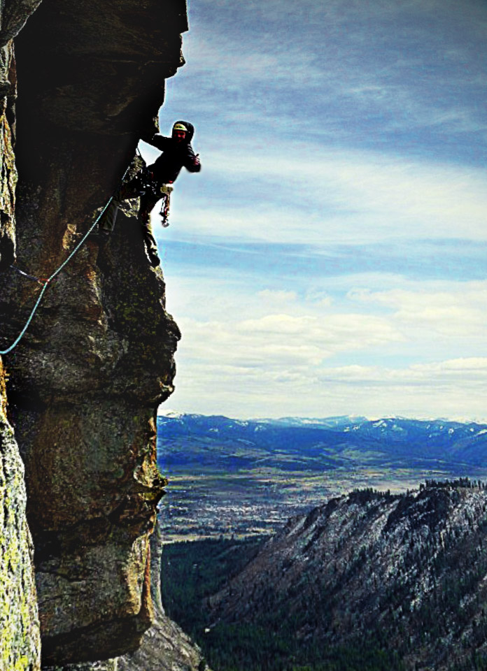 Blodgett Canyon, in the Bitterroot Mountains of western Montana, is a Yosemite-esque sort of place, flanked on the north by sheer granite walls of towering spires that are absolutely irresistible to rock climbers with ropes and stuff.
 Years of drought have drastically lowered the water level of Lake Abbe, along the border between Djibouti and Ethiopia in the Horn of Africa. Vast stretches of what used to be lake bottom are now exposed, including clusters of limestone formations like these, many of which are chimneys venting sulfuric steam.
 Actually, it's a nesting Falcon. I do not pretend to know what this is all about, except that I understand the bird and almost certainly also the tree are Australian.