Nov 13, 2010

The hand-held GPS unit hasn't really revolutionized twenty-first-century life, but the combination of GPS and internet has definitely generated some new recreational obsessions. There is geocaching, for example, in which people search for hidden treasure boxes using geographical coordinates they've downloaded from websites. And on a larger scale, there's confluence-bagging.
A confluence is a point where whole-number coordinates of latitude and longitude intersect--for example, 40 degrees north latitude at 75 degrees west longitude, the closest confluence to where I live. You bag a confluence by visiting it precisely, taking a picture of the numbers displayed on your GPS unit to prove you were really there. After a visit, if you upload the documentation to the
confluence.org website--including a narrative describing your trip and photos of the confluence site, of views in every direction from the point, and of interesting sights nearby--then the ether-world will have a digital record of your achievement. As of today, 11,782 visits to 5,957 confluence points have been documented in the website.
The confluence near my house--40 north, 75 west--is on a golf course fairway in New Jersey; it's easy to find and easy to get to, if the golf course people don't chase you away. Some confluences are more challenging to bag, especially in rough, remote, uninhabited country and in relatively roadless, high-conflict regions, such as East Timor.
Last summer, a team of three Russian confluence-baggers, who have documented visits to some 29 confluence points, devoted their vacation to bagging a few more in Siberia, near Lake Baikal. They visited two watery confluences on the lake itself, traveling 200 nautical miles by boat. Then they got back in their car and sought out the confluence at 52 north 108 east, in logged-over hills east of the lake, in the Siberian republic of Buryatia.
"Having reached the side road to Onokhoy-Shibir," they wrote, "we turned left and drove onto a dirt road headed to our goal.
"We passed a village and reached some road furcation. Guided by GPS arrow, we chose the left road along a creek. Soon the road turned into a clearing for the cable. We slowly dragged our wheels along it until we hit to a high fence." Time to park the car and start walking.
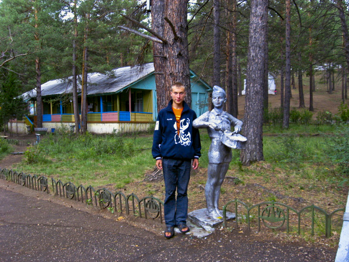
"We were unaware of the existence of a sports training camp, Druzhba (Friendship). The place where a stream flowed under a fence was a secret path on which the 'young pioneers' ran AWOL. We used the hospitality provided by the hole in the fence and got into the camp."
The precise confluence point, it turned out, was near the camp entrance, pictured here, easily accessible by road had they only chosen the correct fork. But by driving directly to the confluence instead of sneaking in like young pioneers returning from some unofficial adventure, "we would have lost the opportunity to plunge into the 1970s and 1980s and feel as the pioneers of those years."
Siberia
GPS
confluence
Lake Baikal
Young Pioneers
Buryatia
(Image credit: Evgeny Krivosudov)
Aug 13, 2012
 The Romans found gold here at Dolaucothi in south Wales, near the village of Pumsaint, in 74 A.D. During five centuries of mining, Roman engineers developed hydraulic works, then a large open pit mine, and eventually vast underground operations, complete with dewatering channels and pumps to keep deep mine tunnels from flooding.
Beginning in the nineteenth century, the British made several tries at reopening the mine, but they gave it up for good in 1938, defeated not so much by lack of gold as by surfeit of water underground. Today, Dolaucothi is a national park, offering mine tours and archaeological exhibits of Roman artifacts found onsite.
landscape
confluence
ruins
mine
gold
Roman engineering
rockscape
Wales
(Image credit: Gordon Spence)

