Hole in the Clouds
Oct 9, 2009
After some of you fussed yesterday about the lack of a story to go with the picture, I've got a story for today--the beginning of a two-part story, in fact. It could be classified as another entry in an irregular series dealing with places I've never been to and probably have no business writing about.
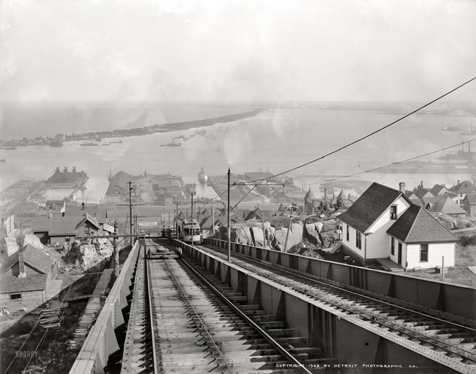
The picture looks down on the harbor of Duluth, Minnesota, in 1905, from a vantage point near the top of the city's new inclined railway. The railway may look like part of the town's extensive industrial infrastructure, but it was actually a people-mover, built by the city in the late ninteenth century at the instigation of real-estate developers who wanted to sell houses high up the hill above downtown. "The Incline" operated for about 50 years, powered by an electric motor at the top and working a little like an elevator, with a dummy-car counterweight on the left track that moved downhill when the passenger car on the right track was pulled uphill.
What I didn't know about Duluth could fill several hard drives. Here's what little I did know: it's Bob Dylan's hometown, and the winters are ridiculously cold. The Dylan factoid is only partly true--yes, he was born in Duluth, but he really grew up a hundred miles north in Hibbing, Minnesota, a mining town that had to relocate itself because the mine got too big. As for the factoid about Duluth winters: yes, of course, they really are brutal, with a spell of forty below or worse most years. But "the Incline" was so steep that snow never piled up too deeply on the tracks, not even during blizzards.
As for the things I didn't know about Duluth: Number one, around the time of this photo, it was among the wealthiest towns in America, claiming more millionaires per capita than anyplace else. It thrived because of a confluence of geology, geography, and the highest technology of the era.
In the 1870s, northern Minnesota had a gold rush; no commercially significant gold was ever found, but the prospectors did stumble on high-grade iron ore in the hills north of Duluth. They'd discovered Minnesota's Iron Range, one of the largest iron deposits on earth and the subject of tomorrow's part of the story.
By the 1880s, Duluth and the Iron Range were connected by railroad. Ore from the mines was off-loaded from the trains at Duluth onto large ships. The ships would have been stuck forever in Lake Superior, unable to exit, had not construction been completed around that time on the mechanized locks at Sault Ste. Marie, which helped ships to descend the 21 feet between Lake Superior and Lake Huron. The ore ships from Duluth sailed a thousand miles across the Great Lakes to the newly constructed steel mills in Indiana and Pennsylvania and Ohio and New York, where newly invented Hulett machines automatically unloaded the ore from the ships and dumped it into blast furnaces. As soon as the new steel cooled, it was snapped up by new factories assembling cars and tractors and locomotives and wringer washing machines and everything else that used to be made in America.
All cities that boom must implode. (I don't know if that's true, but it sounds about right.) What happened to Duluth was World War II, with its extreme demand for iron ore to build tanks and planes and ships to replace the ones that were being consumed in battle. The Iron Range couldn't keep up; huge wartime scrap-metal drives were needed to supplement the mines.The track of the inclined railway was itself torn up and sold for scrap. By about 1950, all the good ore in the entire Iron Range had been clawed out of the earth and shipped away through Duluth. The city languished.
Fortunately, scientists at the University of Minnesota had seen this coming and were hard at work on a work-around. Within a few years they came up with a way of using the Iron Range's low-grade ore, called taconite, Taconite isn't as valuable as the old stuff, and it has to be compete with cheap ore now coming in from places like Brazil, and anyway, most of the old steel mills and factories are no longer operating, but Duluth remains a fairly active port to this day. Last year, it handled 500,000 railroad carloads of taconite. The railroad also brings grain to Duluth from all across the northern Plains, which also gets loaded there onto ships.
But nowadays, more valuable than wheat or taconite to Duluth's economy are tourists. Now that the smoke is gone from the old ore processing works, the city's scenic lakeside setting attracts vacationers interested in all the outdoor activities of the north country: boating, fishing, hunting, snowmobiling, and so on. Along the top of the hill is a string of popular state parks. Even the sand bar that protects the harbor, seen in the distance in the photo, is now a park, and also a seaplane base. Visitors are buying up the old houses on the side of the hill to use as vacation homes.
Somewhere in the city, I can't figure out where, is a trail they've named the Bob Dylan Walking Path. Must be near Highway 61.
vintage
Minnesota
Lake Superior
geology
Duluth
Bob Dylan
(Image credit: Detroit Photographic Co., via Shorpy)
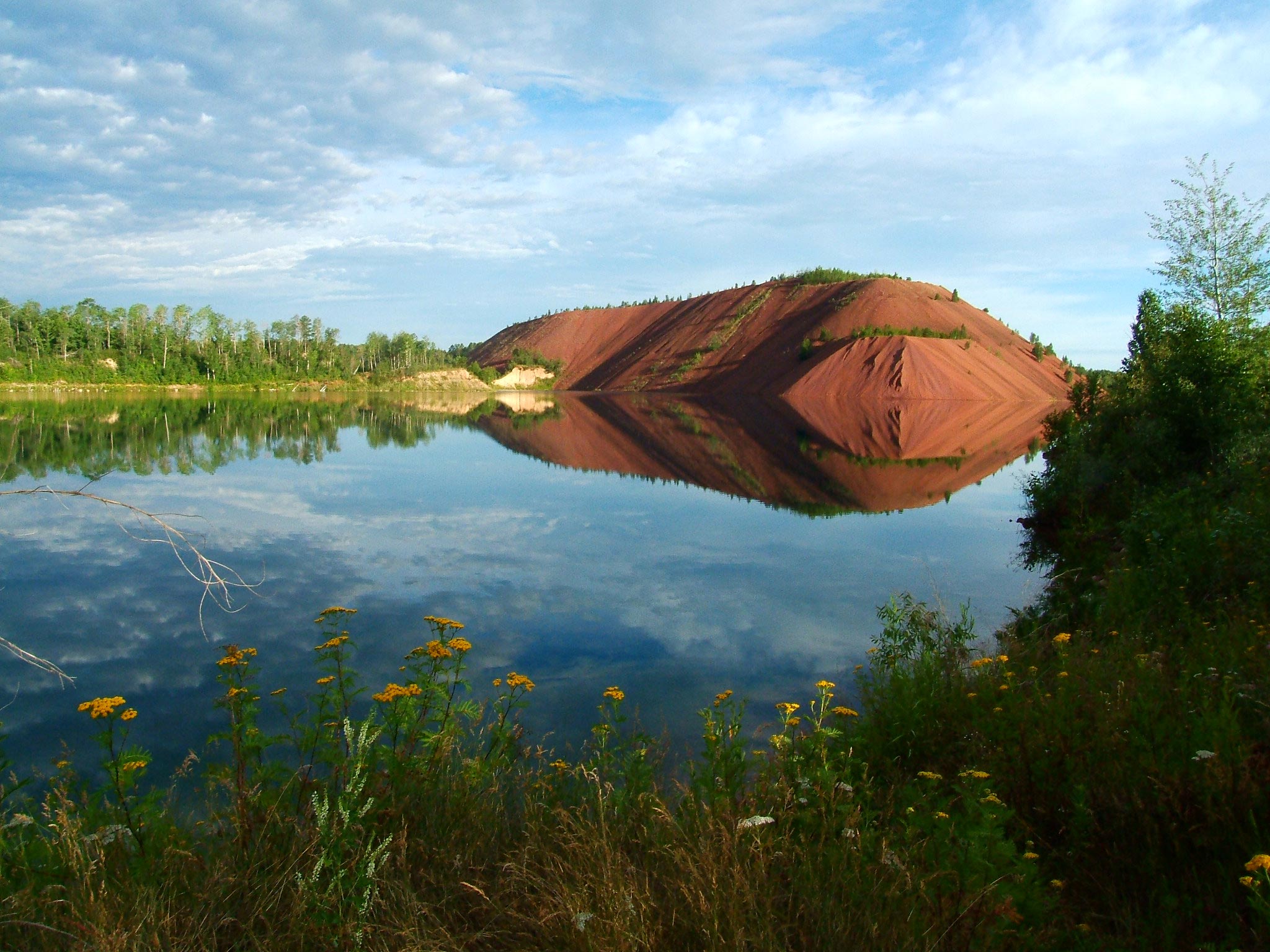
Oct 11, 2009
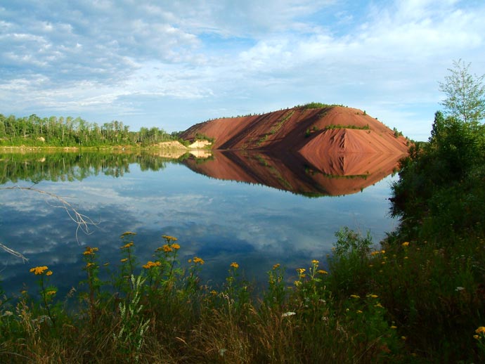
This now quiet flooded hole in the ground was once part of the world's largest open pit iron mine, near Bob Dylan's boyhood home in Hibbing, Minnesota. One-fourth of all the steel ever made in the United States used iron ore from this one mine. The ore sat here for two billion years unmolested, waiting for oxygen to appear in the atmosphere, for life to appear on the surface of earth, and for that life to evolve sufficiently to dig all the iron out of the earth. The digging took about 50 years.
They don't make these big iron deposits any more. Now that the air has oxygen in it, iron will rust away instead of piling up like grains of sand. There are natural processes nowadays that manage to accumulate some iron despite the atmosphere, but they operate on a much, much smaller scale.
Minnesota's Iron Range is what's called a Banded Iron Formation, a BIF. There are fewer than a dozen large BIFs around the world, in Minnesota, Africa, Russia, Australia, Venezuela, Brazil, and Labrador. They are all at least a billion years old; the biggest ones are around two billion years old.
Two billion years is also the age of some of the oldest life forms preserved in the fossil record, organisms called cyanobacteria, ancestors of modern algae. Vast "mats" of cyanobacteria fossils have been found near Hibbing and near many of the world's other banded iron formations.
Coincidence?
Here's one theory: cyanobacteria, sometimes called blue-green algae, were capable of photosynthesis. Like modern plants, they gave off oxygen, which accumulated in the atmosphere and the ocean. The cyanobacteria lived in the ocean, probably near the surface, and the ocean water contained high concentrations of iron, probably leached from early volcanic rocks. Photosynthesis added oxygen to the ocean, which made the iron precipitate out of solution, sinking to the bottom. The iron sediment piled up, and we got our BIFs.
But there's a catch: cyanobacteria are anoxic organisms, which evolved and apparently thrived in a world without oxygen in the air. Their own behavior--photosynthesis--may have contributed to atmospheric changes that literally poisoned them. In other words, they may have caused their own extinction. It may have been a mass extinction, which could explain the huge mats of fossilized cyanobacteria associated with BIFs.
It's hard to imagine how the cyanobacteria could have avoided their fate; they are single-celled organisms with little more brainpower than some of our contemporary politicians. A few varieties did evolve to survive in anoxic niche environments, such as hot mineral springs, but overall their way of life was unsustainable.
Which raises the obvious question: can we humans do any better? As our way of life leads to changes in the atmosphere, can we evolve to survive on an overheated planet? And/or are we smart enough to control the atmosphere to make it more favorable to survival of our species?
Minnesota
geology
Hibbing
global warming
Oct 23, 2009

That's me with the chisel in my mouth, some summers ago, during geologic field work in the North Cascades, in the state of Washington. I'm climbing a hill called Lincoln Rock that rears up about twelve hundred feet above the apple orchards along the banks of the Columbia River. We'd been told there were some good garnet coronas up there--garnets with white rings around them---the metamorphic feature I was trying to interpret for my thesis project.
We'd also been told that Lincoln Rock was the one place in the North Cascades where a geologist named Bob Miller--a man who climbed cliffs for fun when he couldn't think of an excuse to climb them for research--fell badly and almost cracked his head open. This was my last day in the field that summer, and though I'd had wonderful fun, I was beginning to shift gears mentally, to look forward to getting back home so I could stop worrying about slipping and falling and leaving five children motherless.
Perhaps because of Bob's misadventure, but surely also because I was old and out of shape, I was by far the slowest climber. While I toiled upward inch by inch in the August sun, the rest of the gang was already lolling about in the shade of an overhang at the top of the hill, eating lunch and making fun of me. As I finally approached the scene of this snapshot, a Ph.D. student named Carlos Zuluaga asked if I wanted my picture taken. Then he suggested I put the chisel in my mouth. It seemed like a good idea at the time, it really did.
Anyway, there were indeed nice-looking garnet coronas all over the hilltop, and Carlos and the others kindly helped me smash them out of the outcroppings. We all made it down safely, with rocks in our backpacks. When I got a look at my Lincoln Rock samples under the microscope, however, I discovered that the garnets were rotten; they'd cooled too slowly after their metamorphic odyssey, and a mineral named chlorite had replaced much of the garnet. My thermodynamic models wouldn't work on rock with rotten garnet, so I put the Lincoln Rock samples in a drawer in the basement of the geology building, and maybe they are still there today.
Fortunately, I had plenty of other samples. And I'd love to be back up there again.....
Washington
landscape
geology
North Cascades
Lincoln Rock
garnet coronas
(Image credit: Carlos Zuluaga)
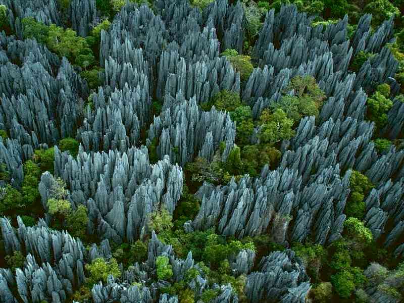
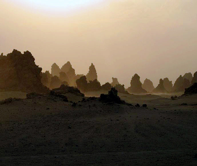
Nov 3, 2009
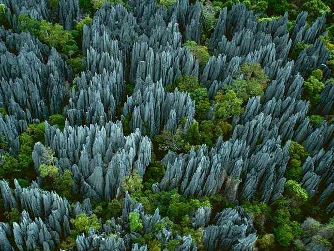
Tsingys. Which means: the kind of place where you don't want to walk barefoot.
We use the German word, karst, as a general term for tsingys and other less extreme landscapes carved by the chemical interaction of limestone and rainwater. Limestone is oceanic in origin, formed at the bottom of the sea from the shells of dead sea creatures. When tectonic forces thrust the seafloor up onto dry land, rainwater immediately begins chewing away at it, in a chemical reaction something like the vinegar-and-baking-soda volcano of an elementary school science project.
Monsoon rains have been attacking the Jurassic limestone bedrock of western Madagascar for millions of years, dissolving channels in the surface and opening up caverns underground. Eventually, as the caverns expand, the rock above tthem collapses, forming sinkholes. The sinkholes enlarge along fissues and underground drainage channels, eventually forming steep-sided "solution valleys." The rains continue to eat away at the rock between the valleys, until all that is left is raggedy spikes. Tsingys.
It's so hard to get around in this landscape that the flora and fauna have yet to be catalogued. Even animals and plants have a hard time traveling here; they live in micro-ecosystems that have evolved in isolation from one another as well as from the rest of the world.
Ten percent of the earth's surface is karst, but most of it is too young or too arid to develop the extreme features of the tsingys. But all karst is evolving slowly or rapidly toward the kind of landscape seen here. It will be kind of a shame in a few million years when Florida gets to looking like this; who's going to want to visit beaches where you can no longer walk barefoot?
landscape
geology
Madagascar
karst
tsingys
(Image credit: Yann-Arthus Bertrand)
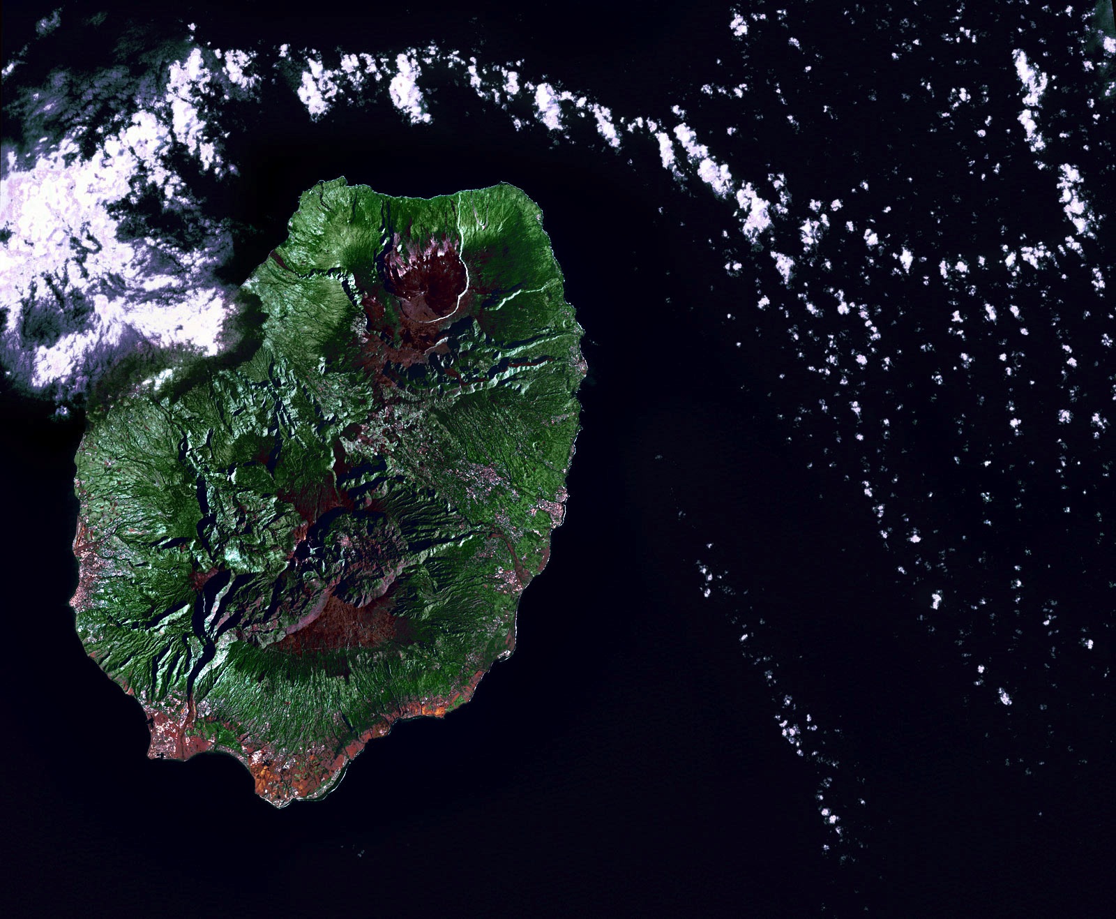
Nov 14, 2009
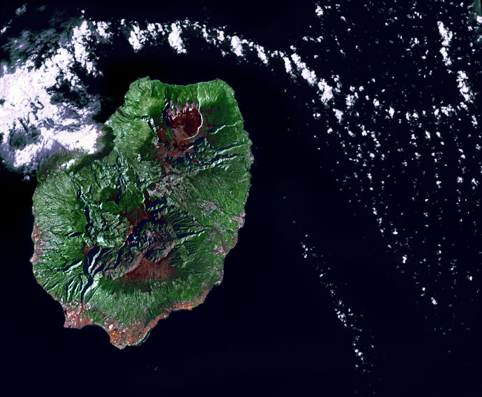
Early in the morning of June 19, 2002, the Landsat 7 satellite swooped across the Indian Ocean and snapped this picture of Reunion Island. The volcano there, Piton de la Fournaise, was quiet that day--the clouds in the picture are just clouds, passing by.
Geologically, Reunion is virtually a twin to Hawaii halfway around the world, a huge shield volcano above an oceanic hotspot. It has been one of the most active volcanoes in the world throughout modern history, erupting almost every year, sometimes more than once, since 1670. The whole island is made of basaltic lava; it's the tip of a volcanic monster mountain rising from the ocean floor. All over the island are volcanic vents, cones, craters, and large calderas, where lava domes exploded and collapsed. The caldera that is currently most active, toward the top of this picture, has slumped down all the way to sealevel at the coast.
Basaltic rock weathers to make rich soil, and here as in Hawaii the climate encourages lush vegetation. New lava doesn't remain bare rock for long.
Politically, Reunion is part of France; because of its time zone far to the east of Europe, the euro became legal currency here a few hours before it did anywhere else. Eight hundred thousand people live on the island.
birdseye view
geology
Reunion Island
Indian Ocean
volcano
(Image credit: NASA Landsat 7)
Dec 17, 2009
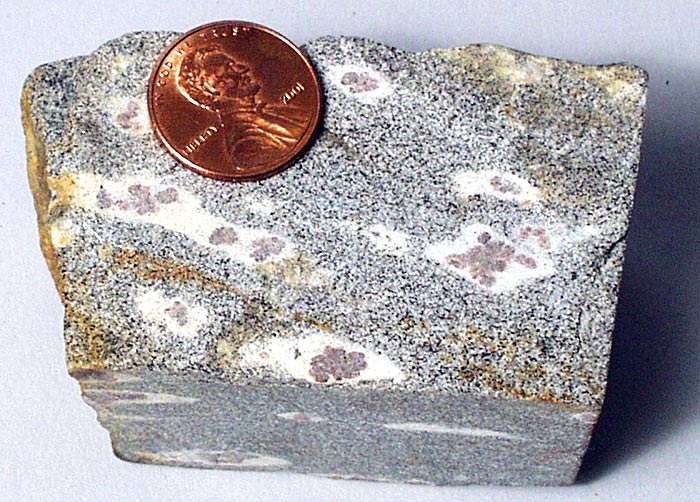
C-T scans have been in the news recently; evidently, they can sometimes be dangerous, zapping people with risky levels of radiation. My master's thesis involved a C-T scan, but fortunately a very safe one, of a rock instead of a human being. Rocks can sit there and take huge doses of X-rays without injury or complaint, making them ideal targets for this sort of procedure. Because there's no need for radiological restraint, scanning a rock can yield much clearer, more detailed results than scanning a live person. It's also a lot cheaper.
The rock I sent to Texas for a C-T scan was a metamorphic chunk of the North Cascades mountains in the state of Washington. It had garnets in it. Each garnet was surrounded by a shell of pure-white minerals: quartz and plagioclase. The rest of the rock--what we termed the matrix-- looked dark gray in color; it actually consisted of the same white minerals as in the shells, flecked with tiny black grains of a kind of mica called biotite.
We were trying to figure out why the garnets were set off from the rock matrix by the white shells, which we called coronas. Our hypothesis was that unusual conditions during the rock's metamorphism had permitted garnet growth but had simultaneously limited diffusion of elements that the garnets would consume during their growth. We wanted to know more about the geometry of the coronas, and about the separation between garnets and matrix. So we shipped a core of rock about an inch in diameter to a C-T lab at the University of Texas, where it was zapped with X-rays; the results were reconstructed by a computer, rendered in 3-D, colorized, and made into a little animated movie.
I've posted the movie on YouTube. I recommend watching it--even if it's not your kind of movie, it only lasts 12 seconds. The garnets in the rock are rendered red, the corona shells green, and the matrix rendered as transparent, with a slight reddish speckling of biotite grains. When I first saw this movie, I'd spent months working with the rock sample, but I was surprised by how long and snake-like the coronas are, and how many clumps of garnets each corona engulfs. How did this happen? The short answer is that the rock got squished squished and heated and stretched and squished and heated again during its mountain-building experience, which coincided roughly with the era of the extinction of the dinosaurs. The long answer is published in a journal called Canadian Mineralogy.
And now, the rock is doing a star turn on the internet, in what I honestly believe to be the first true hard-rock video on YouTube.
geology
North Cascades
garnet coronas
Dec 22, 2010
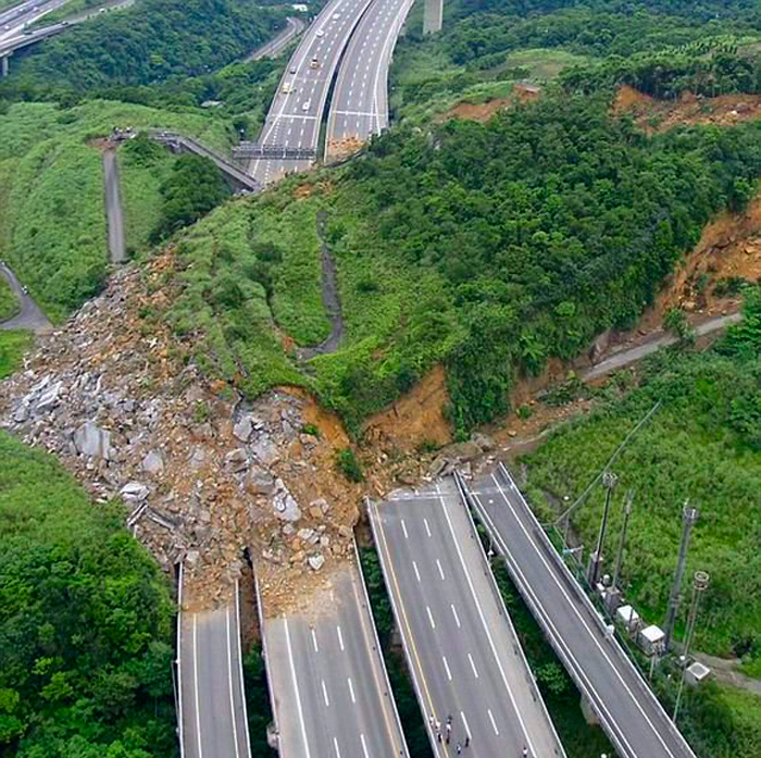
The sun was shining brightly on April 10, 2010, when a hillslide suddenly slumped down onto this highway near Keelong City in northern Taiwan.
The soil was dry. There was no seismic activity in the area. It was just one of those things.
landscape
Taiwan
birdseye view
geology
Keelong City
landslide
mass wasting
Aug 28, 2011
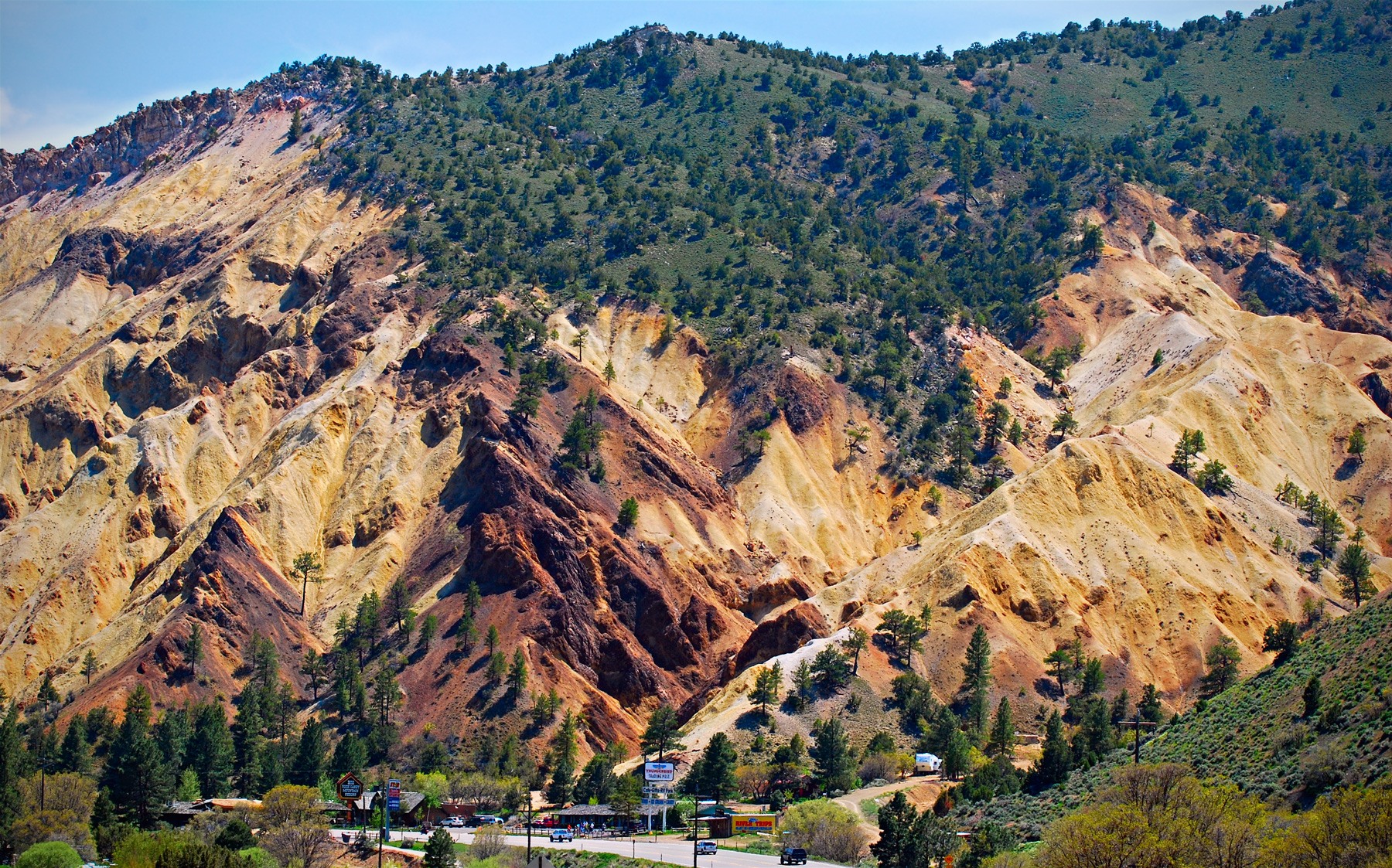
 Well, I didn't know there really was such a thing as the Big Rock Candy Mountain, but here it is, rising above a resort with the same name along Highway 89 near Marysvale, Utah.
Volcanic explosions, followed by magmatic intrusions, followed by twenty-odd-million years of erosion and hot-springs-type chemical interactions have streaked the mountain with colorful mineral deposits. The reddish rocks contain iron-based minerals, including hematite and pyrite, while the whitish rocks contain potassium-based minerals, notably including kaolinite, a valuable white clay used to make paper glossy for magazines or photos.
The mineralization of Big Rock Candy Mountain acidifies runoff water, leaving the soil here relatively inhospitable to vegetation. Nonetheless, ponderosa pine are hanging on, especially near the ridgetop.
It's hard to imagine that in the 1930s there would have been anything about this part of the world that was hospitable to hoboes, either. No lemonade springs, no lakes of stew and whiskey too, no cigarette trees, nothing but more of the longing and aching that inspired Harry McClintock's song.
mountains
music
geology
Utah
Harry McClintock
mineral
Great Depression
Marysvale
hoboes
Burl Ives
(Photo credit: Ray Boren)
Jul 13, 2013
 Years of drought have drastically lowered the water level of Lake Abbe, along the border between Djibouti and Ethiopia in the Horn of Africa. Vast stretches of what used to be lake bottom are now exposed, including clusters of limestone formations like these, many of which are chimneys venting sulfuric steam.
The chimneys formed when the vents were underwater; heat from the steam caused minerals to precipitate out of the lake water and build up around the rims of the vents.
Lake Abbe is a salt lake, the lowest point of a desert drainage system that has nowhere to drain. It's full of steam and sulfur because it's probably the birthplace of a new ocean, a triple junction of spreading faults where three tectonic plates are being pulled relentlessly apart from one another. Two of the faults are already so deep that they are full of ocean water: the Red Sea and the Gulf of Aden. The third fault stretches south from Lake Abbe through eastern Africa as a chain of lakes and deep depressions: the East African Rift.
Along these faults, tectonic plates are pulling apart from one another at rates approaching an inch a year, thinning out the earth's crust in the region, and generating much volcanic activity and gaseous emissions. The geologic evidence strongly supports the likelihood that someday the land around Lake Abbe will be thousands of feet underwater, near the middle of a big blue sea.
But it will take a while. Rifting began here about 60 million years ago. At current rates of divergence, the new basin is spreading roughly 10 miles every million years. In another 100 million years, we'll have an ocean about a thousand miles across.
The drought may (or may not) be over by then.
landscape
geology
Lake Abbe
triple junction
tectonics
Djibouti
limestone
Horn of Africa
(Image credit:
Sep 7, 2013
 It must have been Oscar Wilde who said that you could never be overdressed or overeducated. In fact, he may be saying it just now, as he contemplates the world outside his childhood home in Dublin's Merrion Square, dressed to the nines from the neck down and wearing a becoming shade of snark across his face.
Sculptor Danny Osborne was as much prospector as artist for this project. He found the jade for Wilde's smoking jacket in extreme northern British Columbia, near the Yukon border. The pink collar and cuffs are from manganese-rich veins of zoisite in Norwegian shale.
The shimmery trousers are larkivite, also from Norway, a coarse-grained rock rich in anorthoclase feldspar, mined in Oslo Fjord. The well-polished shoes are black charnockite, from southern India; they get their shine from a distinctive kind of pyroxene known as hypersthene.
The 35-ton boulder that Wilde lounges on is Irish, but it's not in situ; Osborne found it in the Wicklow Mountains outside of Dublin.
The statue was sponsored by the Guinness Ireland Group and dedicated in 1997, ninety-seven years after Wilde's death at age 46.
It seemed appropriate, even necessary, to end this posting with a Wildeism. Settling on a single passage, however, proved ridiculously difficult, and it is certainly unfair to the man to reduce him to well-dressed witticism. But this line may do as well as any: "Every saint has a past, and every sinner has a future."
Or this: "Being natural is simply a pose."
geology
art
rocks
sculpture
Oscar Wilde
Dublin
Danny Osborne
(h/t: Janet Goldwater)
May 26, 2014
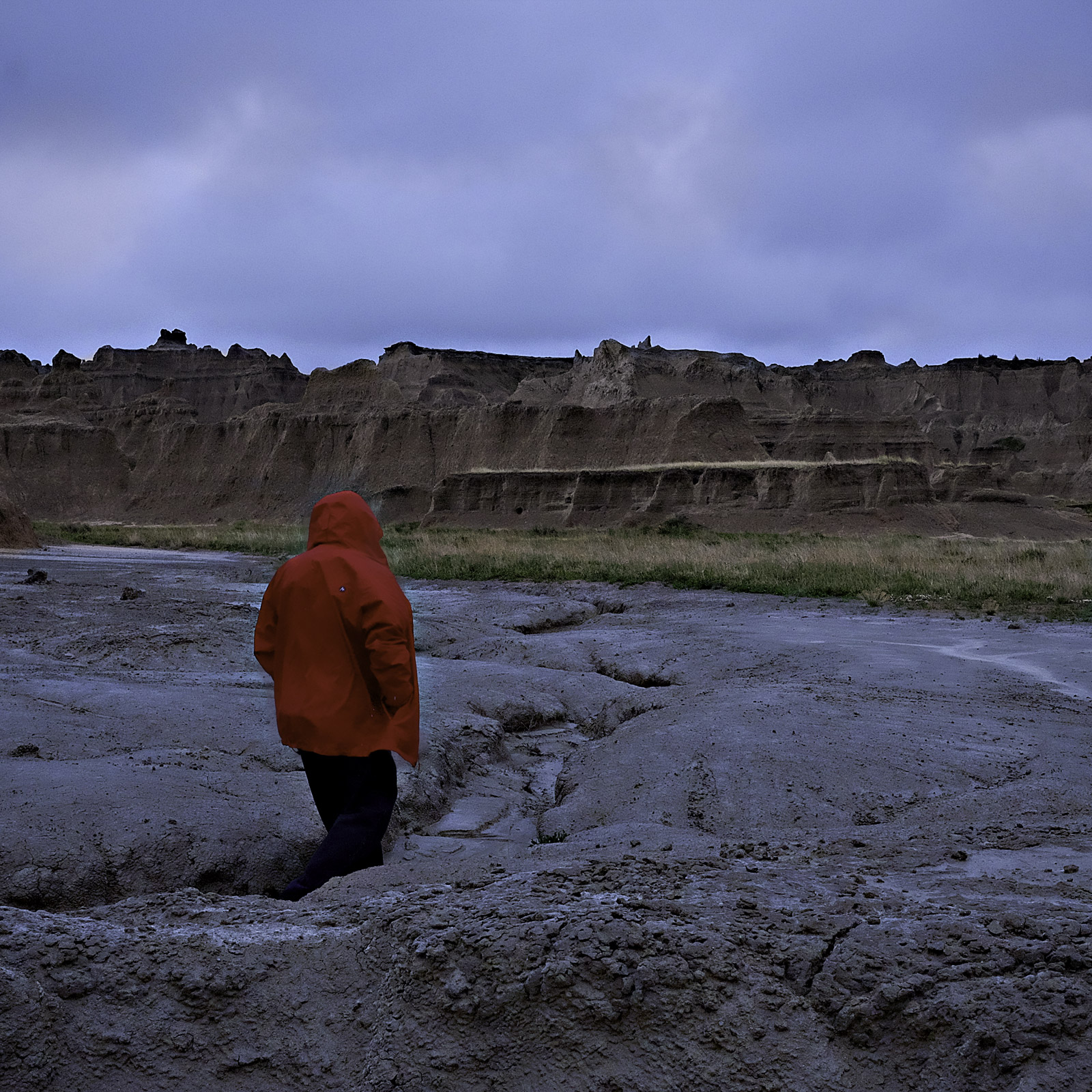
 All it took was a few days of bad weather like this, every year for maybe half a million years, and most of the sediment that used to blanket this part of South Dakota has washed on down the White River and then into the Missouri and the Mississippi and the Gulf of Mexico.
This was an ancient seabed, back in the day, deeply mucky, collecting sand and silt and mud from the Black Hills nearby and the Rockies beyond. The sediments piled up in layers hundreds of feet thick, but when the ancient sea drained and the lithified muck was exposed to the elements, wind and rain and frost proved to be powerful chisels.
It's believed that in another half million years, the remaining spires and parapets will have crumbled down into the gullies, and it'll be curtains for the scenery hereabouts.
landscape
geology
Norman
South Dakota
Badlands National Park
erosion
(Image credit: Little Fuji)
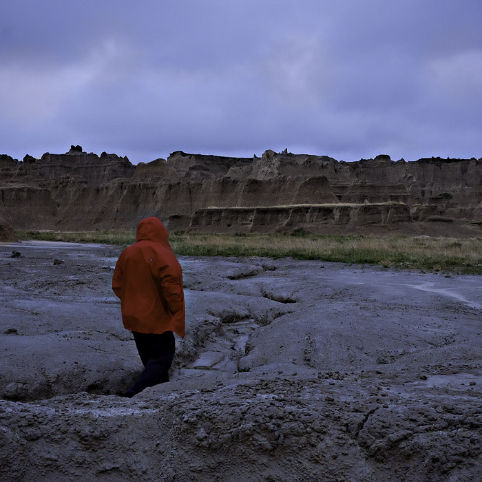
Jul 21, 2014
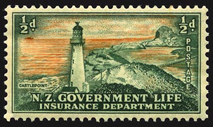
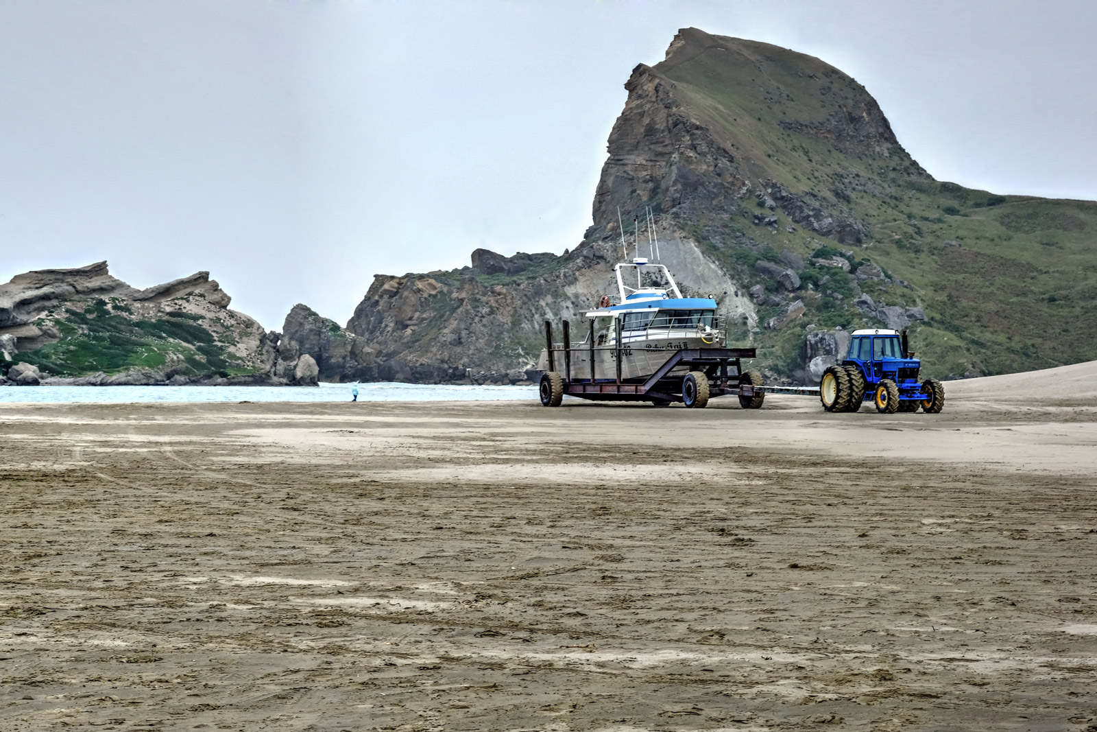
At the north end of Castlepoint sheep station is Castle Rock itself, noted and named in the eighteenth century by Captain Cook. The rock anchors one end of a limestone reef; on the headland at the other end is Castlepoint Lighthouse, built in 1913, originally fueled by oil but now wired into the grid and controlled from a switchboard in Wellington, a couple of hours away. Its light is visible 22 miles out at sea.
The postage stamp above dates from 1947. For almost a century beginning in the 1890s, the New Zealand government operated a life insurance company that had government franking privileges and printed its own stamps. Lighthouses were nineteenth-century symbols for insurance companies (as were big rocks, e.g., Mutual of Omaha). The government sold off its insurance operations in the 1980s, to a corporation doing business as Tower Life of Dunedin, New Zealand.
The reef at Castlepoint is not at all like the coral reefs growing placidly around tropical lagoons; geologically, it's a chunk of ancient seafloor millions of years old heaved up violently during seismic activity associated with the collision of the Pacific and Australian tectonic plates.
The limestone in the reef is richly fossiliferous, and directly underneath the lighthouse it's pocked with caves.
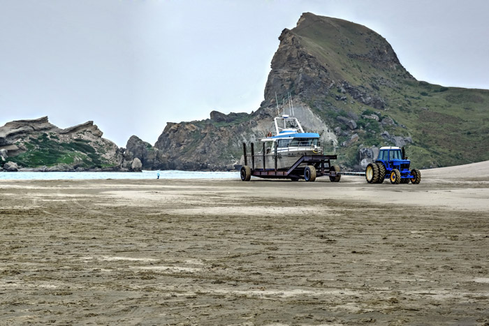
Inside the reef is a lagoon and a wide, hard-sand beach, crucial features in the development of a large sheep station here, back in the days before highways. Since the coast in this region has no natural harbors, sheepmen used to drive wagonloads of wool bales down the beach, to be loaded at water's edge into small boats that ventured out at high tide to meet up with cargo ships waiting offshore.
Today, shipping activity at Castlepoint is mostly recreational in nature, and the hard-packed beach now serves tractors and boat trailers. The blue tractor in the picture below is driverless and remote controlled from the boat, where the captain calls for it to push an empty trailer down into the surf and then pull the loaded trailer back up to high ground.
In the picture below, the tiny figure walking the beach near water's edge is my mother-in-law.
beach
sheep
New Zealand
geology
rock
Pacific Ocean
history
Wairarapa
lighthouse
(Image credit: Little Fuji [lower photo])
Aug 24, 2014
On Saturday morning, geophysicists believed Iceland's Bardarbunga volcanic system had begun erupting beneath the huge glacier that hides it from view. By Saturday evening, however, new data or new interpretations of the data were raising doubts about this conclusion; the magma might still be trapped in rock a few kilometers below the bottom of the ice.
The actual eruption might have already begun or might begin at any moment or might never happen at all. But Bardarbunga's magma is definitely on the move down there in the earth's crust, melting some of the rock in its path and shouldering the rest out of its way, along a northeasterly route tracked by literally thousands of earthquakes.
Halldor Eldjarn has set the earthquake data to music, which you can listen to in near-real time.
music
geology
volcano
Iceland
earthquakes
Bardabunga
glacier