Hole in the Clouds
Dec 29, 2010
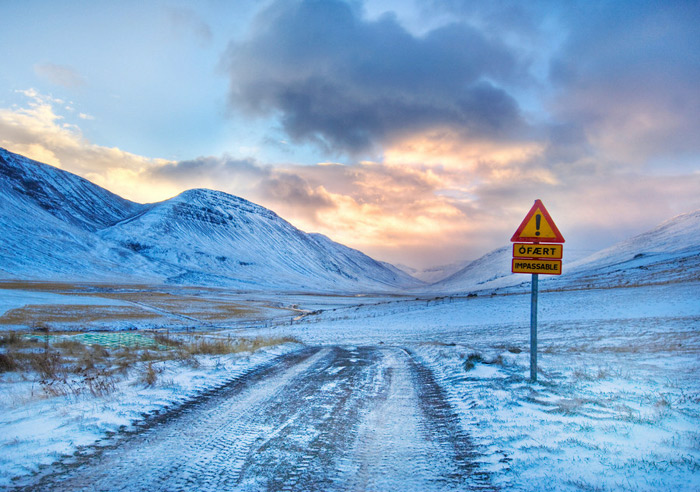 On December 29, 2010, sunrise in Reykjavik, Iceland, will be at 11:23 a.m., and sunset will come just a little over four hours later, at 3:36 p.m. So if this road into the mountains outside of town is the route recommended by the GPS . . . well, maybe try again in a few months, when the daylight last a little longer?
The Icelandic word on the warning sign translates into English as unable, more or less.
landscape
sunset
yellow signs
Iceland
(Image credit: Trey Ratliffe)
Aug 24, 2014
On Saturday morning, geophysicists believed Iceland's Bardarbunga volcanic system had begun erupting beneath the huge glacier that hides it from view. By Saturday evening, however, new data or new interpretations of the data were raising doubts about this conclusion; the magma might still be trapped in rock a few kilometers below the bottom of the ice.
The actual eruption might have already begun or might begin at any moment or might never happen at all. But Bardarbunga's magma is definitely on the move down there in the earth's crust, melting some of the rock in its path and shouldering the rest out of its way, along a northeasterly route tracked by literally thousands of earthquakes.
Halldor Eldjarn has set the earthquake data to music, which you can listen to in near-real time.
music
geology
volcano
Iceland
earthquakes
Bardabunga
glacier
Sep 15, 2014
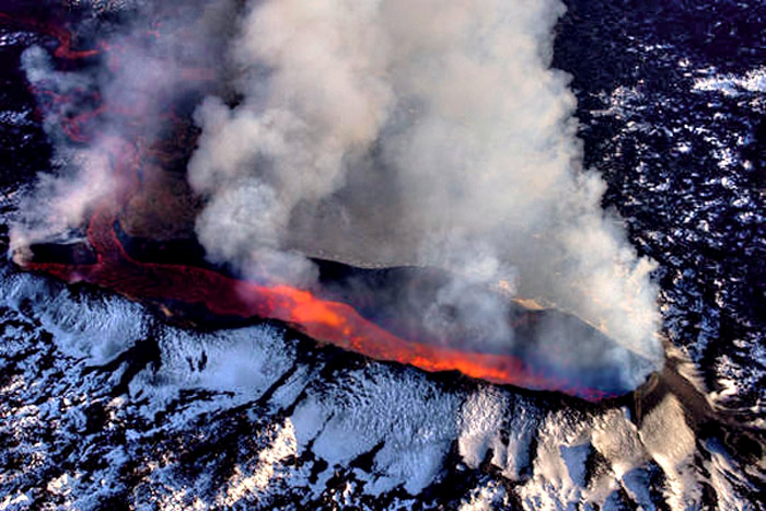
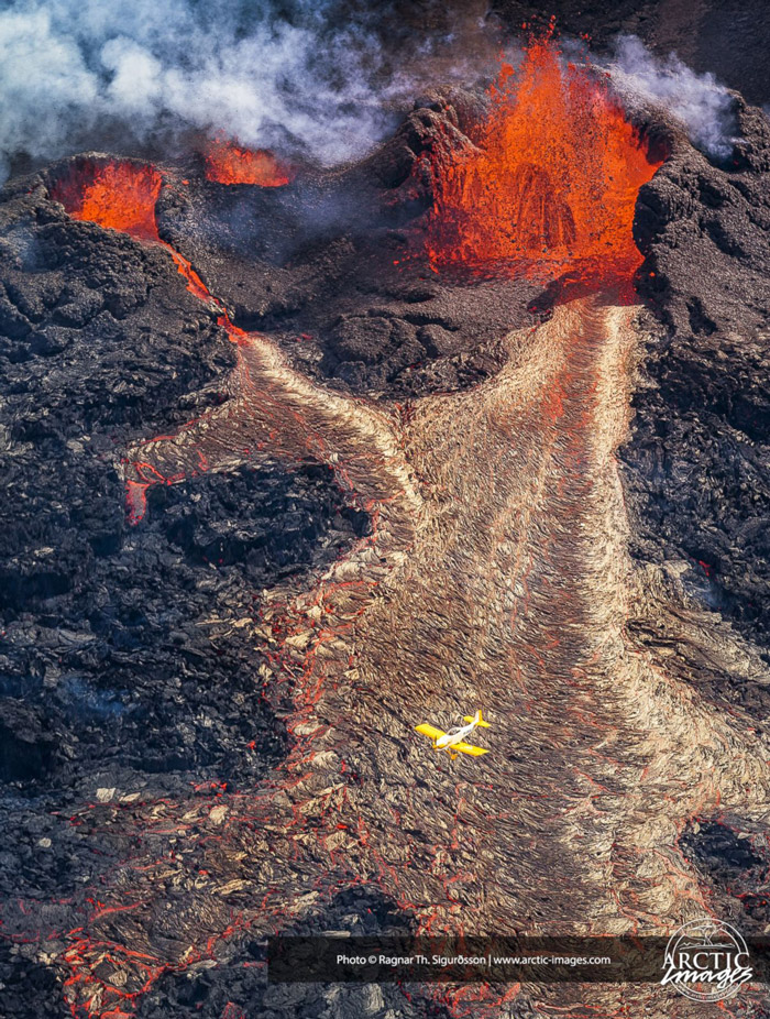 Tectonic drama is vividly on display these days in central Iceland, where the trailing edges of two continental plates–the North American and Eurasian plates–are tearing the island apart.
The Atlantic Ocean is growing wider and wider, at an average rate of about an inch a year. The seafloor bulges upward in the middle, where the tectonic plates meet, and cracks develop in the bulging ridge. These fissures fill up immediately with magma squirted up from deep below the earth's crust.
When the magma erupts at the surface–at which point it's called lava instead of magma–it cools and hardens into new rock, lodged in between the edges of the two old plates. This process, called rifting, pushes the plates further and further apart.
Iceland is one of the few places on earth where rifting is visible above the water. The fissure eruption currently active near a large old volcano called Bardarbunga is not particularly explosive–no threat to airplanes at the moment–and it is occurring in an unpopulated area where there is little risk to people or property. In fact, the scene of the eruption is a desolate plain called Hohluraun, which is covered with old lava from ancient eruptions.
There is concern that the fissure may "unzip" back toward Bardarbunga, in which case the eruption could spread underneath hundreds of meters of snow and ice in Europe's largest glacier. Much of the glacier could be vaporized by the heat of the eruption, creating a massive steam explosion and ash cloud.
There is also concern that the lava erupting from the fissure is emptying out the old magma chamber underneath Bardarbunga volcano, which is the largest in Iceland. Ongoing earthquakes are readjusting the mountain as the partially empty magma chamber caves in on itself; if one of the earthquakes breaches the chamber, the explosion and eruption could become as large as any in recorded history. Bardarbunga's last eruption was the largest in the past 10,000 years.
But it won't be apocalyptic; it won't extinguish life as we know it. It will just darken the skies for a while and widen the Atlantic Ocean by a bit.
Or: the current fissure eruption could die down in a day or a month or a year, leaving central Iceland quiet and relocating the scene of the next tectonic drama to some other time and place.
volcano
Iceland
tectonics
Bardabunga
graben
fissure eruption
rifting
(Image credit: Ragnar Siguurdsson at Arctic-Images.com)
Nov 8, 2014
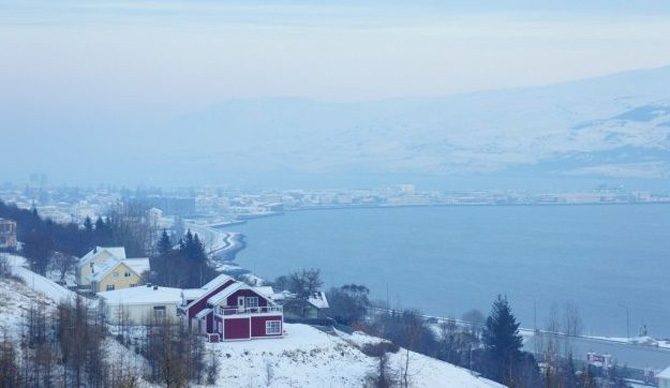
Our last look at Iceland's ongoing volcanism touched on matters of earthquakes, a collapsing caldera, magma, lava, and tectonic rifting. But we failed to discuss the issue that has come to preoccupy Icelanders in recent months: poison gas, which spreads across the island as a blue haze, threatening the health of people, livestock, crops, and vegetation.
The gas belches out of the lava as sulfur dioxide, SO2, which is the odor we sniff in minute amounts when we strike a match. Around the site of the eruption, in barren terrain near central Iceland's Bardarbunga volcanic complex, the sulfur dioxide is so intensely concentrated that a single breath could be fatal. Fortunately, no one lives nearby; researchers approaching the volcanic vent wear elaborate gas masks and stay in the vicinity for only a few minutes at a time.
In addition to being dangerously sulfurous, the air near the eruption is also extremely turbulent. Steam from the vent and heat gusts from the surface of the lava lift and disperse the SO2 quite quickly. Early in the eruption, huge pulses of steam pushed the gas so high into the atmosphere that it was entrained in the jet stream and carried in low but measureable concentrations across the sea to northern and western Europe.
Within a few days, however, as the volcanic vent opened fully, the lava spilled out less forcefully. Sulfur dioxide was no longer blasted into the upper atmosphere; instead, it has settled as a smoggy blue haze, rolling along the surface of Iceland. The haze is steered by winds; an east wind blows it into Reykjavik, as seen above, while winds from other points of the compass blow it to every nook and cranny of the island.
When the haze is bad, Icelanders are told to stay indoors, close their windows, and run their heat full blast. Measured concentrations are well above known hazard levels, and people with weak lungs or compromised immune systems face serious health risks. Even healthy people experience burning eyes and throats, headaches, fatigue, and various degrees of breathing difficulties. Those who have to stay outdoors try to keep nose and mouth covered and are warned to avoid heavy exertion.
But the symptoms are temporary; the wind changes, the blue haze disappears, and everybody feels better. Children are allowed back outside to play.
The haze is not pure sulfur dioxide. It's more insidious than that. The SO2 combines with water vapor in the volcanic steam and the general atmosphere to produce aerosols of sulfurous acid, H2SO3, one of the principal components of acid rain.
And that's not the worst of it. The H2SO3 reacts with oxygen in the air to create a much more corrosive, extremely dangerous compound: sulfuric acid, H2SO4.
People can protect themselves from the worst of all this, but animals and plants, of course, are entirely exposed. They will suffer long-term effects. Iceland's last high-sulfur volcanic eruption, known as Laki, killed three-quarters of the country's livestock in 1783 and led to massive crop failures. Thousands of people died of starvation.
The volume of lava and sulfur spewed forth by Laki, however, is believed to be about fifteen times the amount currently erupting from Bardarbunga–500,000 metric tons daily from Laki, as opposed to 35,000 tons daily from Bardarbunga.
The current sulfur emissions are roughly comparable to the amount already entering the air every day from all the smokestacks in Europe. Iceland is a tiny place to be dealing with as much poison in the air as the entire continent of Europe.
The eruption is now two and a half months old. There are no signs that it is winding down just yet; it could continue for many more months, or years.
For what it's worth, sulfur dioxide is not a greenhouse gas; in fact, it blocks sunlight and has an overall cooling effect. As winter darkness envelops Iceland now, there's less and less sunlight to be blocked; if the sulfur is still hanging around next spring, the chill of an Icelandic winter may persist even longer than usual.
landscape
birdseye view
volcano
Iceland
pollution
Bardarbunga
(Image credit: Skapti Hallgrimsson)
Feb 25, 2015
 Icelandic authorities reported this week that the five-month-old volcanic eruption known as Holuhraun shows numerous signs of winding down, at least for the moment. They believe that volcanism in that part of the country is entering a new phase
The lava flow has decreased dramatically. After spilling wildly for months over an area the size of a large city, the lava now is mostly pooling in a single crater before it trickles out across the landscape.
The population of Iceland is no longer suffering from the volcano's poisonous gases, though gas concentrations in the immediate vicinity of the eruption are still at deadly levels. It has been two weeks since any populated area experienced serious atmospheric pollution.
Earthquake activity associated with the eruption is way down, though officials still describe it as very high. Yesterday, about 25 earthquakes shook the region, all smaller than 3.0. Until recently, the daily count was usually 80 or more, some of them above magnitude 5.0.
Holuhraun has been fed with magma from a chamber underneath Iceland's largest volcano, the glacier-covered Bardarbunga. As the magma chamber emptied out, Bardarbunga mountain began collapsing in on itself, subsiding more than 100 meters since measurements began in September. The rate of subsidence has dramatically slowed in recent weeks; yesterday, it was just 2 cm.
Clearly, Holuhraun is running on fumes now and is likely to cease significant eruption in the near future. But volcanologist Armann Hoskuldsson cautions that the overall volcanic episode may not be anywhere near complete and in fact may be just now entering a much more active phase.
Tectonically, the Holuhraun eruption involves rifting; the lava is actually creating new land in between two diverging tectonic plates. Hoskuldsson notes that rifting episodes last much longer than five months–usually at least ten years–and they typically involve multiple eruptions, often much more ferocious than Holuhraun.
Iceland
tectonics
rifting
eruption
volcano. Bardarbunga
fissure
Holuhraun
(Image credit: Ólafur Sigurjónsson)
Feb 14, 2017
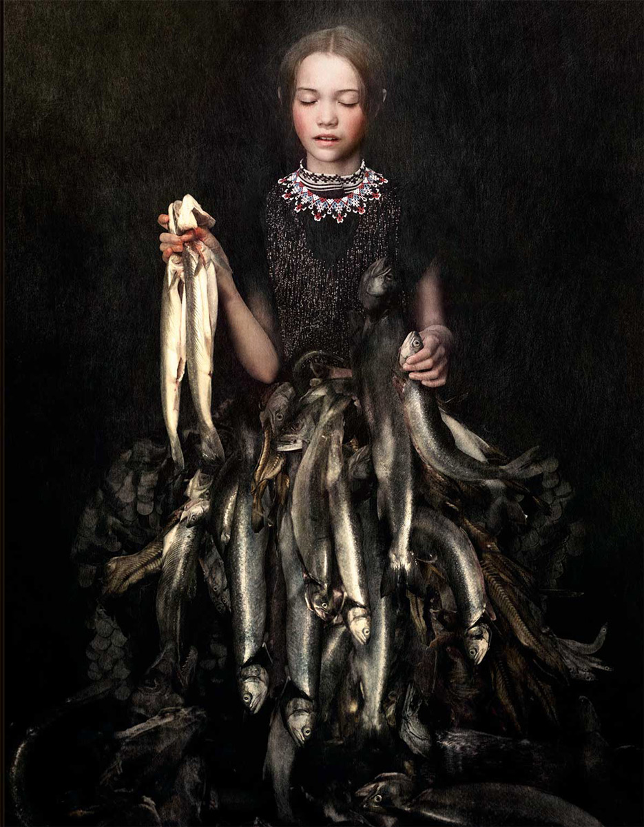
 The harsh, moody climate and mysterious, treeless landscapes that define the western Nordic islands–Iceland, Greenland, the Faroe Islands–are swept up somehow and transformed by imagination into a fashion sensibility, the focus of the Third Nordic Fashion Biennale.
Curators Sarah Cooper and Nina Gorfer–American and Austrian by birth, Stockholm-based photographers by choice–have produced an exhibition, book, and film they call The Weather Diaries, which explore fashion as a wind-blown wonder.
landscape
Iceland
fashion
photography
style
Faroe Islands
The Weather Diaries
Greenland
(Image credits: Cooper & Gorfter)
 On December 29, 2010, sunrise in Reykjavik, Iceland, will be at 11:23 a.m., and sunset will come just a little over four hours later, at 3:36 p.m. So if this road into the mountains outside of town is the route recommended by the GPS . . . well, maybe try again in a few months, when the daylight last a little longer?