Hole in the Clouds
Nov 14, 2009
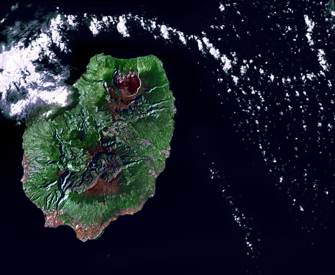
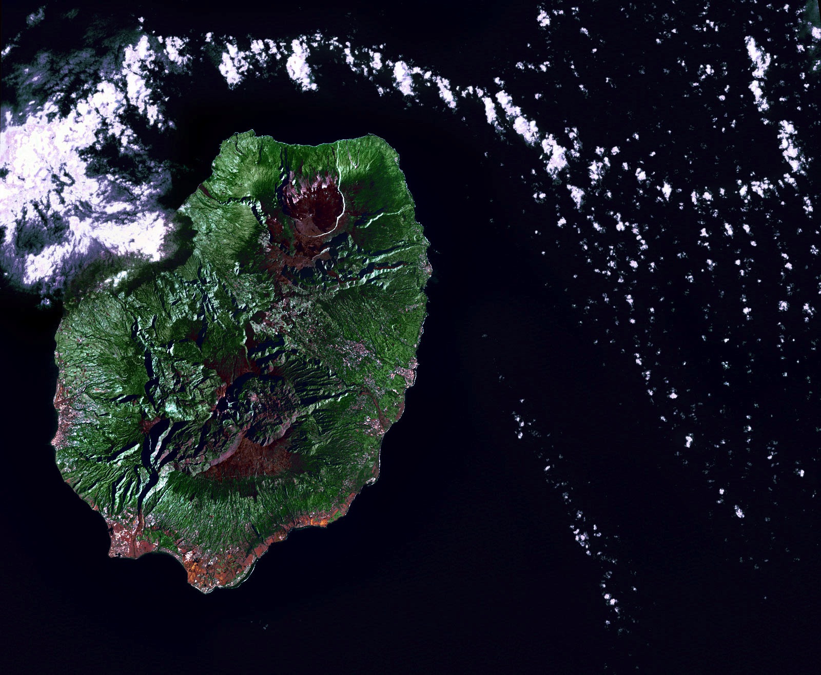
Early in the morning of June 19, 2002, the Landsat 7 satellite swooped across the Indian Ocean and snapped this picture of Reunion Island. The volcano there, Piton de la Fournaise, was quiet that day--the clouds in the picture are just clouds, passing by.
Geologically, Reunion is virtually a twin to Hawaii halfway around the world, a huge shield volcano above an oceanic hotspot. It has been one of the most active volcanoes in the world throughout modern history, erupting almost every year, sometimes more than once, since 1670. The whole island is made of basaltic lava; it's the tip of a volcanic monster mountain rising from the ocean floor. All over the island are volcanic vents, cones, craters, and large calderas, where lava domes exploded and collapsed. The caldera that is currently most active, toward the top of this picture, has slumped down all the way to sealevel at the coast.
Basaltic rock weathers to make rich soil, and here as in Hawaii the climate encourages lush vegetation. New lava doesn't remain bare rock for long.
Politically, Reunion is part of France; because of its time zone far to the east of Europe, the euro became legal currency here a few hours before it did anywhere else. Eight hundred thousand people live on the island.
birdseye view
geology
Reunion Island
Indian Ocean
volcano
(Image credit: NASA Landsat 7)
Oct 22, 2010
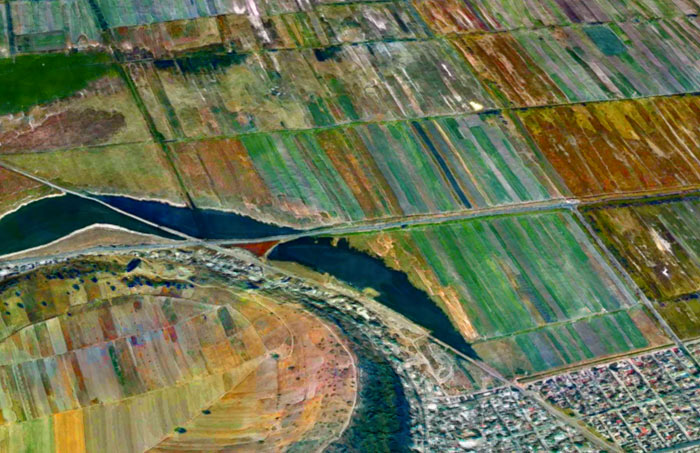
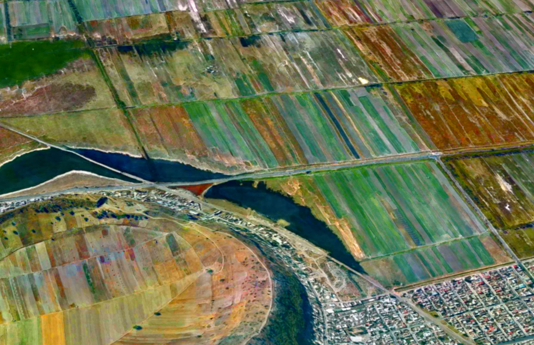
If you drop the first two letters of the name of the nation of Mexico, you get Xico, the name of several towns and landmarks around the country. There is, for example, the small hill town of Xico near Veracruz, where it is said that people do very little besides growing coffee and hosting bullfights. And here we see two other Xicos: a volcanic crater and the fast-growing city that surrounds it.
Xico volcano sits at the extreme southern end of the Mexico City megalopolis. For a geologically significant chunk of time, this area was underwater, drowned by Lake Chalco. The lake began to dry out in the 1300s, and Aztec fishermen settled along its coastline hereabouts. In the nineteenth century, the government drained the lake entirely; the fishermen were awarded communal land grants and told to become farmers.
Farming became intensive in the 1970s, when corporate agriculturists and desperate landless peasants struck illegal or quasi-legal deals with the communal organizations and wrested control of the rich volcanic soil. Thousands and thousands of families poured into the region, hoping for work. Farmers climbed over the rim of the volcano and plowed fields inside the crater. Xico the town sprawled right up to the ramparts of Xico the crater and appears likely to soon engulf it; in 2005, the population of the municipality was 330,000.
The urban fringes seen here lack the services and amenities taken for granted twenty miles away in downtown Mexico City. Xico's roads are mostly unpaved, schools are few and far between, and the people are almost all very poor. Now that NAFTA has dismantled the remains of the communal farming system, it seems to be increasingly the case that even the rich volcanic soil here in Xico is worth more as slumland than as cropland.
landscape
birdseye view
volcano
Mexico
satellite imagery
remote sensing
(Image credit: NASA Landsat 7)
Feb 17, 2011
 At the extreme Pacific end of Russia, north of China and Korea and Japan, the volcanoes of the Kamchatka Peninsula are erupting again.
This is nothing new; the 29 volcanoes of Kamchatka’s mountainous spine—10 percent of the world’s active volcanoes—have erupted prodigiously and often for at least the last two million years.
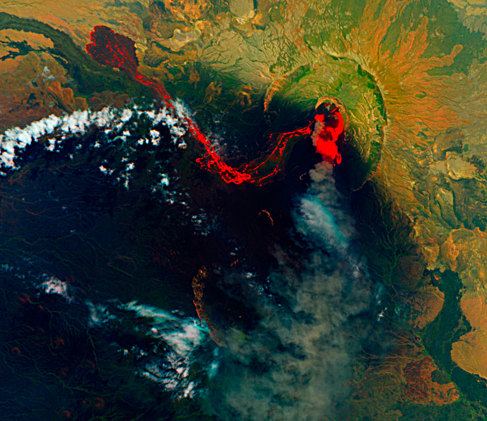
Since October, three of them have been seriously erupting, spewing ash 32,000 feet into the sky and devastating their surroundings with earthquakes, lava flows, mudslides, and pyroclastic catastrophe. Shown here is last week’s eruption of Shiveluch, the northernmost of the currently active volcanoes. This picture is thermal imagery from satellite sensors; the hottest areas are shown as white, with progressively less hot regions appearing as gradations of yellow through orange to red.
Shiveluch had a lava dome near its peak—a rocky bulge inflated by molten magma underground. This thermal image tells us that the dome has now burst; the white splotch at the mountain peak shows extremely hot lava exposed at the surface. The rock that used to overlie the lava dome would have been pulverized in the eruption and sent skyward as ash or down the mountainside as a pyroclastic flow, a fiery nightmare of lava, ash, rock, mud, and poisonous gases.
The image also shows a large pool of hot lava that has collected at the bottom of the mountain, beginning to cool off around the edges. Undoubtedly, forest land in this valley has been devastated, but because the Shiveluch region is virtually uninhabited, damage associated with human activity is expected to be very low.
However, planes traveling between Alaska and Korea or Japan often fly just east of Kamchatka. The dust plumes from Shiveluch and the other two currently active volcanoes have sometimes been large enough to pose a potential risk to aviation.
This video from last October, when the level of activity was not yet as intense, shows both the ash clouds rising and the lava descending from Shiveluch:
Russia
volcano
Shiveluch
Kamchatka
(Image credit: NASA ASTER sensors on TERA satellite)
Jul 9, 2011
 About three weeks ago, the Nabro volcano in the East African nation of Eritrea began erupting for the first time in recorded human history. The initial eruption was a violent explosion, pumping vast quanitities of ash and sulfur dioxide into the air above North Africa and the Middle East. Aviation in the region was briefly suspended. Nabro's dark, dense plume of ash and gases shrouded the mountaintop for two weeks, concealing the eruption from view until June 29, when this satellite image was captured.
The image shows that the eruption has transitioned to a quieter, oozing sort of phase. Hot lava glows orange, fading to black as it cools. The lobes at the end of the long lava flow are dark, suggesting that the top of the flow may have crusted over. As the long westward flow cools, hotter, fresher lava appears to be spilling out of the vent toward the south and east.
Nabro is in very arid, dusty country; the green patches in the landscape around the volcano are actually only sparsely vegetated. The image was captured using a combination of infrared and visible light, which misrepresents the degree of vegetation in the landscape.
Although the eruption is a first for the record books, Nabro is in the East African rift valley, where volcanic activity in one form or another is nearly constant. Three tectonic plates are pulling apart from one another in this region, stretching the earth's crust so thin that hot magma from deep below finds numerous weak spots through which to erupt.
birdseye view
infrared
volcano
satellite imagery
Eritrea
Rift Valley
Nabro
(Image Credit: NASA–EO1)
Jan 3, 2012
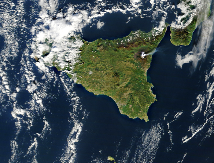 Right around this time last year, Mt. Etna in Sicily started doing this. Again.
birdseye view
volcano
Italy
satellite imagery
remote sensing
clouds
Mt. Etna
Sicily
Mediterranean
(Image credit: NASA MODIS satellite)
Aug 24, 2014
On Saturday morning, geophysicists believed Iceland's Bardarbunga volcanic system had begun erupting beneath the huge glacier that hides it from view. By Saturday evening, however, new data or new interpretations of the data were raising doubts about this conclusion; the magma might still be trapped in rock a few kilometers below the bottom of the ice.
The actual eruption might have already begun or might begin at any moment or might never happen at all. But Bardarbunga's magma is definitely on the move down there in the earth's crust, melting some of the rock in its path and shouldering the rest out of its way, along a northeasterly route tracked by literally thousands of earthquakes.
Halldor Eldjarn has set the earthquake data to music, which you can listen to in near-real time.
music
geology
volcano
Iceland
earthquakes
Bardabunga
glacier
Sep 15, 2014
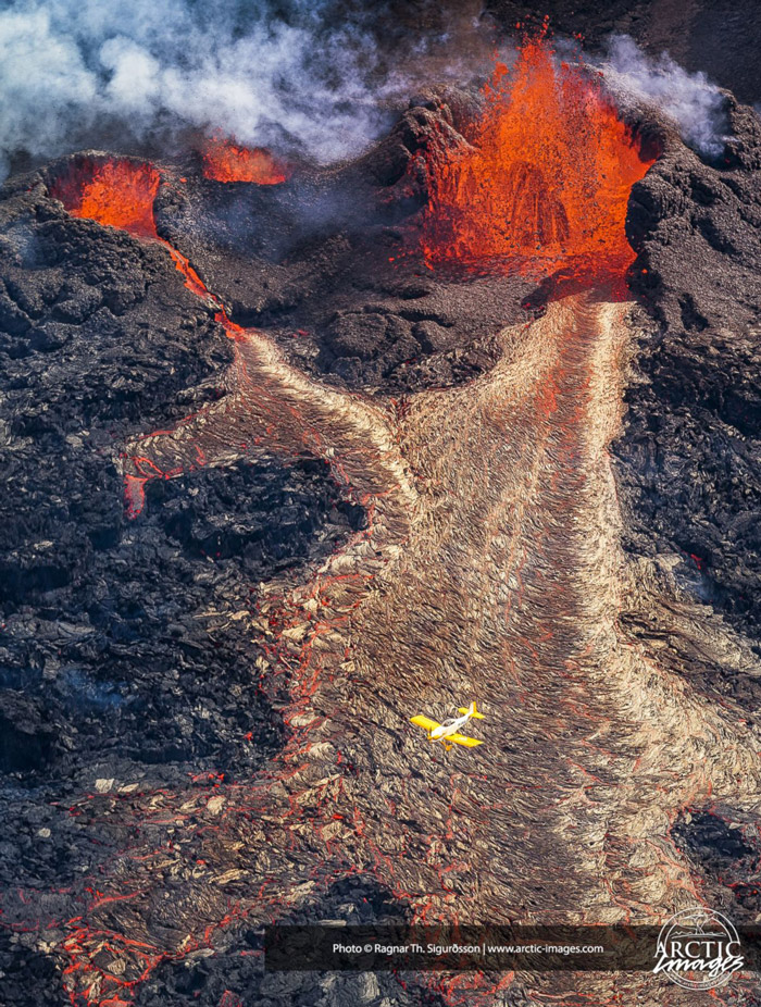 Tectonic drama is vividly on display these days in central Iceland, where the trailing edges of two continental plates–the North American and Eurasian plates–are tearing the island apart.
The Atlantic Ocean is growing wider and wider, at an average rate of about an inch a year. The seafloor bulges upward in the middle, where the tectonic plates meet, and cracks develop in the bulging ridge. These fissures fill up immediately with magma squirted up from deep below the earth's crust.
When the magma erupts at the surface–at which point it's called lava instead of magma–it cools and hardens into new rock, lodged in between the edges of the two old plates. This process, called rifting, pushes the plates further and further apart.
Iceland is one of the few places on earth where rifting is visible above the water. The fissure eruption currently active near a large old volcano called Bardarbunga is not particularly explosive–no threat to airplanes at the moment–and it is occurring in an unpopulated area where there is little risk to people or property. In fact, the scene of the eruption is a desolate plain called Hohluraun, which is covered with old lava from ancient eruptions.
There is concern that the fissure may "unzip" back toward Bardarbunga, in which case the eruption could spread underneath hundreds of meters of snow and ice in Europe's largest glacier. Much of the glacier could be vaporized by the heat of the eruption, creating a massive steam explosion and ash cloud.
There is also concern that the lava erupting from the fissure is emptying out the old magma chamber underneath Bardarbunga volcano, which is the largest in Iceland. Ongoing earthquakes are readjusting the mountain as the partially empty magma chamber caves in on itself; if one of the earthquakes breaches the chamber, the explosion and eruption could become as large as any in recorded history. Bardarbunga's last eruption was the largest in the past 10,000 years.
But it won't be apocalyptic; it won't extinguish life as we know it. It will just darken the skies for a while and widen the Atlantic Ocean by a bit.
Or: the current fissure eruption could die down in a day or a month or a year, leaving central Iceland quiet and relocating the scene of the next tectonic drama to some other time and place.
volcano
Iceland
tectonics
Bardabunga
graben
fissure eruption
rifting
(Image credit: Ragnar Siguurdsson at Arctic-Images.com)
Nov 8, 2014
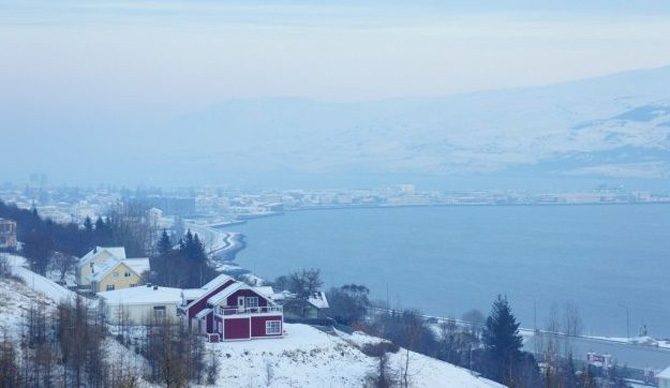
Our last look at Iceland's ongoing volcanism touched on matters of earthquakes, a collapsing caldera, magma, lava, and tectonic rifting. But we failed to discuss the issue that has come to preoccupy Icelanders in recent months: poison gas, which spreads across the island as a blue haze, threatening the health of people, livestock, crops, and vegetation.
The gas belches out of the lava as sulfur dioxide, SO2, which is the odor we sniff in minute amounts when we strike a match. Around the site of the eruption, in barren terrain near central Iceland's Bardarbunga volcanic complex, the sulfur dioxide is so intensely concentrated that a single breath could be fatal. Fortunately, no one lives nearby; researchers approaching the volcanic vent wear elaborate gas masks and stay in the vicinity for only a few minutes at a time.
In addition to being dangerously sulfurous, the air near the eruption is also extremely turbulent. Steam from the vent and heat gusts from the surface of the lava lift and disperse the SO2 quite quickly. Early in the eruption, huge pulses of steam pushed the gas so high into the atmosphere that it was entrained in the jet stream and carried in low but measureable concentrations across the sea to northern and western Europe.
Within a few days, however, as the volcanic vent opened fully, the lava spilled out less forcefully. Sulfur dioxide was no longer blasted into the upper atmosphere; instead, it has settled as a smoggy blue haze, rolling along the surface of Iceland. The haze is steered by winds; an east wind blows it into Reykjavik, as seen above, while winds from other points of the compass blow it to every nook and cranny of the island.
When the haze is bad, Icelanders are told to stay indoors, close their windows, and run their heat full blast. Measured concentrations are well above known hazard levels, and people with weak lungs or compromised immune systems face serious health risks. Even healthy people experience burning eyes and throats, headaches, fatigue, and various degrees of breathing difficulties. Those who have to stay outdoors try to keep nose and mouth covered and are warned to avoid heavy exertion.
But the symptoms are temporary; the wind changes, the blue haze disappears, and everybody feels better. Children are allowed back outside to play.
The haze is not pure sulfur dioxide. It's more insidious than that. The SO2 combines with water vapor in the volcanic steam and the general atmosphere to produce aerosols of sulfurous acid, H2SO3, one of the principal components of acid rain.
And that's not the worst of it. The H2SO3 reacts with oxygen in the air to create a much more corrosive, extremely dangerous compound: sulfuric acid, H2SO4.
People can protect themselves from the worst of all this, but animals and plants, of course, are entirely exposed. They will suffer long-term effects. Iceland's last high-sulfur volcanic eruption, known as Laki, killed three-quarters of the country's livestock in 1783 and led to massive crop failures. Thousands of people died of starvation.
The volume of lava and sulfur spewed forth by Laki, however, is believed to be about fifteen times the amount currently erupting from Bardarbunga–500,000 metric tons daily from Laki, as opposed to 35,000 tons daily from Bardarbunga.
The current sulfur emissions are roughly comparable to the amount already entering the air every day from all the smokestacks in Europe. Iceland is a tiny place to be dealing with as much poison in the air as the entire continent of Europe.
The eruption is now two and a half months old. There are no signs that it is winding down just yet; it could continue for many more months, or years.
For what it's worth, sulfur dioxide is not a greenhouse gas; in fact, it blocks sunlight and has an overall cooling effect. As winter darkness envelops Iceland now, there's less and less sunlight to be blocked; if the sulfur is still hanging around next spring, the chill of an Icelandic winter may persist even longer than usual.
landscape
birdseye view
volcano
Iceland
pollution
Bardarbunga
(Image credit: Skapti Hallgrimsson)
Jan 1, 2015
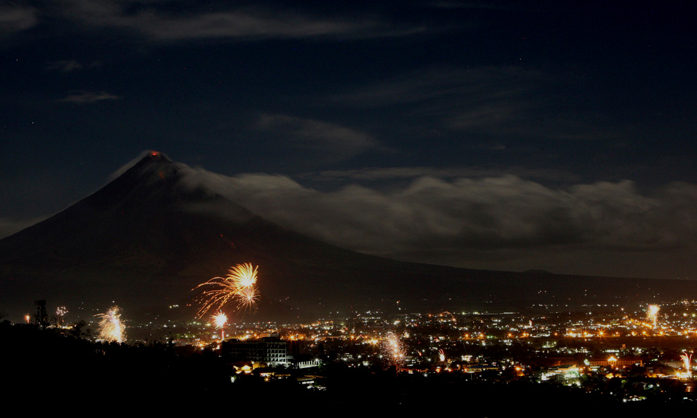 In the earliest moments of the year 2010, the people of the Filipino city of Legazpi, south of Manila, celebrated with fireworks, as the Mayon volcano in the distance stirred up some fireworks of its own.
As we slip slide into 2015, here's hoping we all stay warm and healthy and full of sparks. And where's that cup of kindness when we need it?
landscape
night
volcano
New Year's
fireworks
Mayon