Hole in the Clouds
Mar 2, 2010
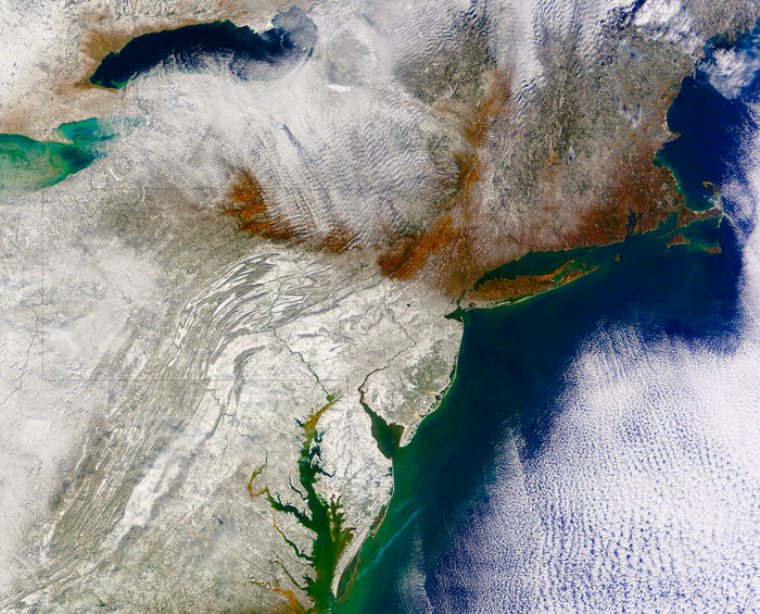 The first step in making sense of this image is distinguishing the two kinds of white stuff, clouds and snow. There's a big area of clouds over the Atlantic Ocean at the right edge of the picture, especially in the lower right, and another batch of clouds near the top of the image, streaming southeastward from Lake Ontario. The two cloud regions are connected in the upper right corner by a puffy little cloud bridge over . . . Portland, Maine. But that's irrelevant to the main point.
The edge of the snow line is obvious, running almost straight westward from Long Island and New York City, and it's completely upside down and backwards. North of the snow line, bare ground and leafless brown trees are clearly visible to the sensors of a satellite hundreds of miles out in space. South of the line, the satellite registers bright white ground, buried deep in snow.
This is not how winter is supposed to be in the eastern United States, but in 2010, this is the pattern that held steady through most of January and February. It is just now breaking up, though there's still something of an upside-down snow line in northern New England.
What went wrong? Part of the blame lies with Greenland. Normally, a dome of dry, cold, heavy air sits over Greenland all winter long, known as the Greenland High. Storms in the Atlantic can't punch through this high pressure, so they steer around it, generally tracking up the coast alongside New England and into the Canadian Maritime provinces. This year, the Greenland High was diffuse and deformed and further south than usual, with a well-developed ridge near the North American mainland, far from its usual core. Storms crawling up the mid-Atlantic coast slammed into the high-pressure ridge and couldn't go any further; they wore themselves out dumping snow on Virginia and Maryland and New Jersey and Pennsylvania.
To compound the trouble, this was an El Nino year, meaning there were lots of storms with lots of moisture.
Does this have anything to do with global warming? Of course it does, but it will be years or maybe decades before the details of the relationship become clear. When a winter is snowier than average, or less snowy than average, or a high pressure feature is shifted out of its typical position--that's weather, not necessarily climate. There's always weather, blips and static that obscure the deeper patterns arising from long-term trends in climate. Only over time can the climatic signal be recognized amidst the weather-related noise.
Meanwhile, the snow in this picture highlights a completely unrelated geological phenomenon. Notice the snowy folds of the Appalachian Mountains, ridge upon ridge, all trending northeast-southwest. The Appalachians are hundreds of millions of years old, dating back to the tectonic processes that created Pangaea and then ripped it apart. If you click on the picture to get a larger version, you should be able to see three black snakey lines, rivers that cut right across all the mountains--the Potomac, the Susquehanna, and the Delaware. Does that make sense? Wouldn't it be more logical for big rivers to follow the valleys instead of ignoring the valleys and flowing across the mountains?
This unusual river behavior has been talked about for centuries; Thomas Jefferson wrote that the place where the Potomac cuts through mountains near Harpers Ferry, West Virginia, was worth crossing the ocean to see. The place where the Delaware River splits a mountain range--the Delaware Water Gap--has been declared a national park.
How does it happen? It's a complicated story. The Appalachians are basically several mountain chains jammed together side by side. The westernmost chain is among the oldest, now quite eroded, but it was once high and steep, like the Alps. Big rivers formed to drain the high country. Later, as tectonic rifting opened the Atlantic basin, new mountains gradually emerged east of the original range. The big, powerful rivers draining the old mountains were strong enough to cut through the rising land, and so they held onto their river beds even as the mountains rose around them.
winter
satellite imagery
East Coast
(Image credit: NOAA)
May 24, 2010

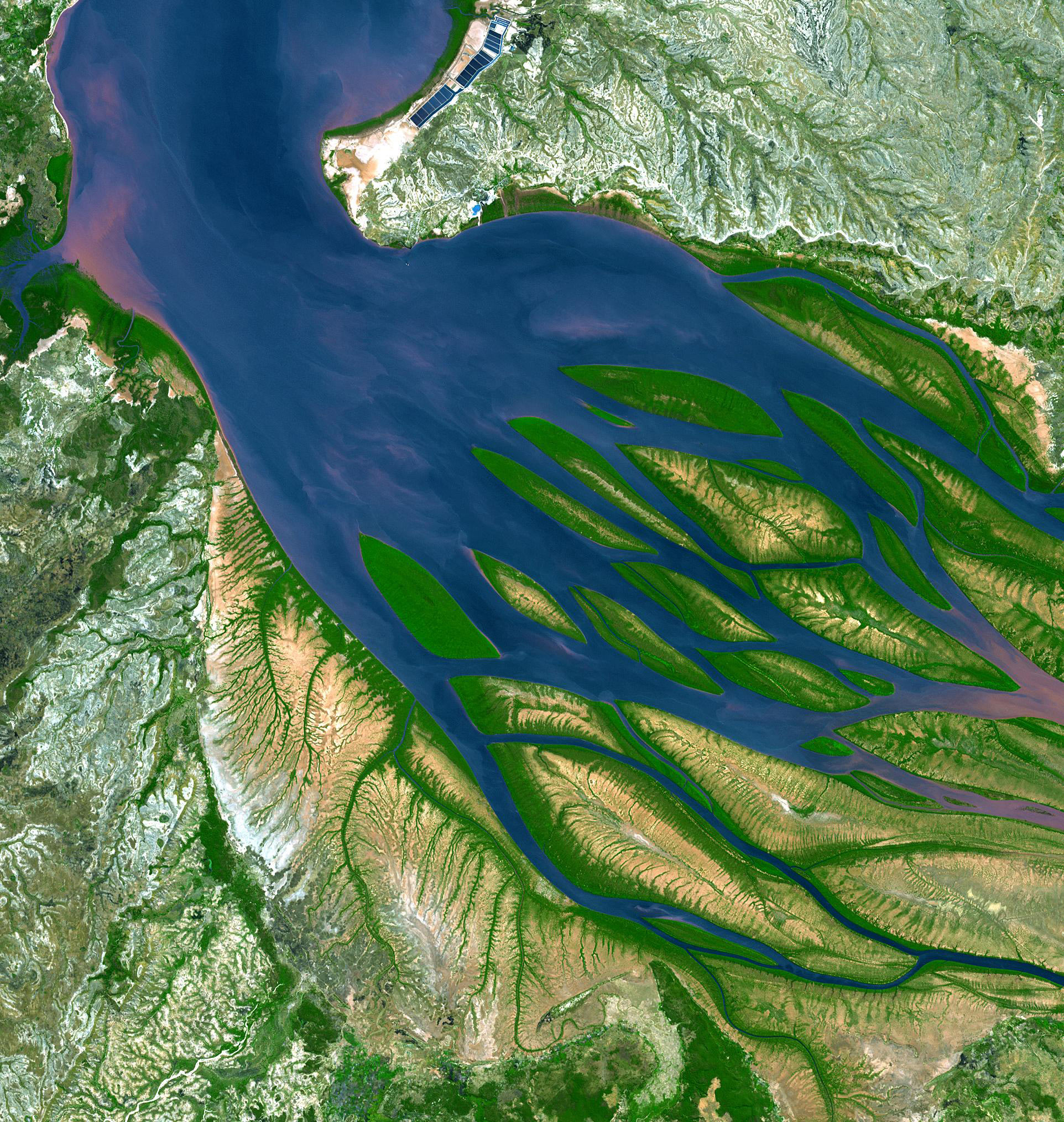
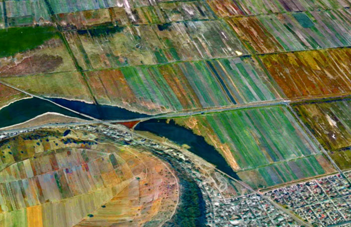
The Bestiboka River reaches the sea in the Mozambique Channel, along the northwestern coast of the island of Madagascar. There at the mouth of the river, ocean tides push saltwater upstream, slowing or even halting the downstream flow of the muddy river water; wherever the river pauses, sand and silt drop to the bottom of the bay, piling up into sandbars and islands.
In Madagascar's tropical climate, new sandbars quickly acquire a fringe of bright green mangrove scrub, which stabilizes the sediment and also shelters baby shrimp and other aquatic critters. Bombetoka Bay, the estuary here, is highly productive, especially for shrimp. The rectangular pens near the top of this picture are commercial shrimp farms.
The mangrove swamps along the lower reaches of the river trap vast quantities of sediment pouring down from upstream, which keeps the water clean and free of mud as it enters the bay; without this mangrove filtering, Madagascar's huge coral reefs just offshore (off the top edge of this picture) would soon die, smothered by sand.
birdseye view
Madagascar
satellite imagery
remote sensing
Bombetoka Bay
(Image credit: NASA ASTER satellite)
Jun 11, 2010
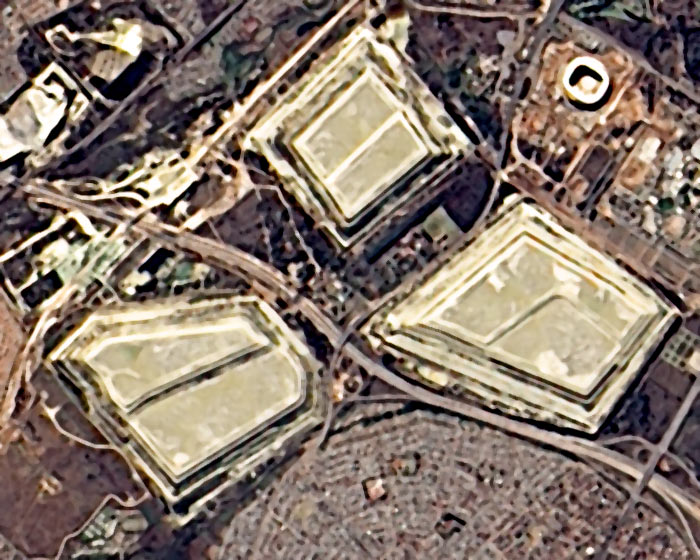
Last week, a NASA satellite flew over South Africa so its sensors could snap this picture of the soccer stadium, known as Soccer City, where World Cup action begins today.
The stadium itself is the white rounded rectangle in the upper right corner of the image. The three big grayish things in the middle are slag heaps, the rocky refuse of more than a century of gold-mining activity in the Johannesburg district.
At the bottom edge of the picture is part of Diepkloof, one of the neighborhoods of Soweto. When Nelson Mandela was let out of prison in 1990, he made his first public appearance in the Soccer City stadium. In this same stadium today, the South African national team challenges Mexico in the opening game of the FIFA World Cup; sadly, Mandela, once a soccer player himself and a lifelong sportsman, is said to be too frail to attend. He is 91 years old.
As this posting goes to, um, press, Mexico has just tied South Africa, 1-1, in the opening game.
birdseye view
satellite imagery
remote sensing
Johannesburg
South Africa
Soweto
Soccer City
mining
(Image credit: NASA Advanced Land Imager)
Oct 22, 2010
If you drop the first two letters of the name of the nation of Mexico, you get Xico, the name of several towns and landmarks around the country. There is, for example, the small hill town of Xico near Veracruz, where it is said that people do very little besides growing coffee and hosting bullfights. And here we see two other Xicos: a volcanic crater and the fast-growing city that surrounds it.
Xico volcano sits at the extreme southern end of the Mexico City megalopolis. For a geologically significant chunk of time, this area was underwater, drowned by Lake Chalco. The lake began to dry out in the 1300s, and Aztec fishermen settled along its coastline hereabouts. In the nineteenth century, the government drained the lake entirely; the fishermen were awarded communal land grants and told to become farmers.
Farming became intensive in the 1970s, when corporate agriculturists and desperate landless peasants struck illegal or quasi-legal deals with the communal organizations and wrested control of the rich volcanic soil. Thousands and thousands of families poured into the region, hoping for work. Farmers climbed over the rim of the volcano and plowed fields inside the crater. Xico the town sprawled right up to the ramparts of Xico the crater and appears likely to soon engulf it; in 2005, the population of the municipality was 330,000.
The urban fringes seen here lack the services and amenities taken for granted twenty miles away in downtown Mexico City. Xico's roads are mostly unpaved, schools are few and far between, and the people are almost all very poor. Now that NAFTA has dismantled the remains of the communal farming system, it seems to be increasingly the case that even the rich volcanic soil here in Xico is worth more as slumland than as cropland.
landscape
birdseye view
volcano
Mexico
satellite imagery
remote sensing
(Image credit: NASA Landsat 7)
Jun 9, 2011
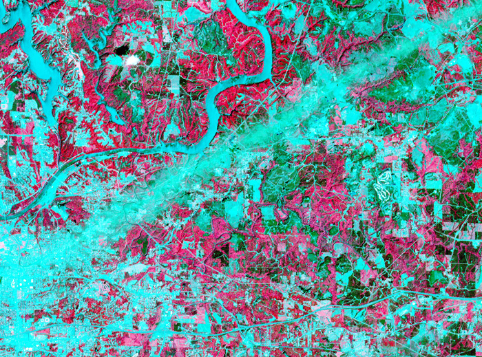 On April 28, 2011, the visible-light and infrared sensors of NASA's ASTER satellite captured this image of Tuscaloosa County, Alabama, which had been raked by an especially large and powerful tornado just the day before.
Infrared sensors are useful for distinguishing between vegetated and non-vegetated land cover. The pink areas in the photo represent vegetation–forests, pastures, cropland, golf courses. Areas that show up as aqua are non-vegetated or very lightly vegetated–cities, highways, rivers, strip mines, recent clearcuts.
The tornado track is obvious here: a straight aqua-colored streak running from the southwest to the northeast. Vegetation in this streak that was not directly destroyed by the storm was so littered with pieces of buildings and household objects that satellite sensors could barely detect it.
Just north of the storm track is the twisting course of the Black Warrior River, which shows up in aqua. The city of Tuscaloosa is mostly south of the river, at the left edge of the picture. In the upper left corner of the picture is Lake Tuscaloosa, a dammed-up tributary to the Black Warrior that provides the city's drinking water.
NASA's spokespeople assert that images such as this one can be useful in the aftermath of storms. They may help identify storm-damaged places outside of populated areas, where tornadoes might escape public awareness. And by proving the time and location of tornado paths, they could help homeowners support their insurance claims for storm damages.
If you click on the picture to see the larger version, you can follow numerous roads out into the countryside and observe that many of them seem to end with a little dot of aqua, indicating a non-vegetated spot. These are well pads for methane rigs. About fifteen years ago, the Black Warrior basin was the scene of one of the nation's first methane gas drilling booms. Coalfields underlie much of west Alabama, including almost all of Tuscaloosa County, but until recently the methane gas associated with coal deposits was considered a danger rather than an economically valuable fuel. "Fracking" technology, in which high-pressure liquids are injected deep into the earth to crack open the rocks hosting methane, was developed and refined in Alabama; drilling for methane is now under way all over the world. Unlike oil or traditional natural gas, methane is best extracted by small wells located within a few hundred feet of numerous other small wells; thus, the countryside is speckled with hundreds or thousands of separate well pads.
Tuscaloosa
Alabama
birdseye view
infrared
satellite imagery
tornado
methane
fracking
(Image credit: NASA ASTER satellite)
(h/t: Chuck Horowitz
Jul 9, 2011
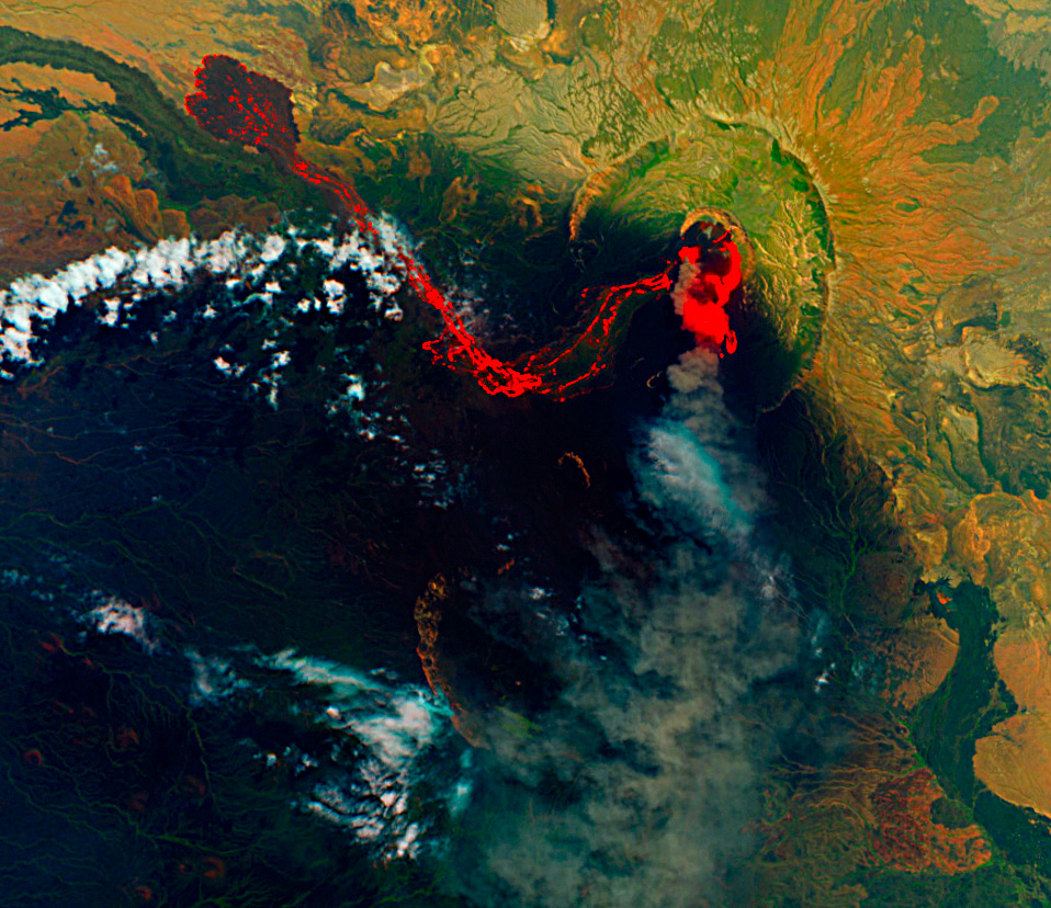
 About three weeks ago, the Nabro volcano in the East African nation of Eritrea began erupting for the first time in recorded human history. The initial eruption was a violent explosion, pumping vast quanitities of ash and sulfur dioxide into the air above North Africa and the Middle East. Aviation in the region was briefly suspended. Nabro's dark, dense plume of ash and gases shrouded the mountaintop for two weeks, concealing the eruption from view until June 29, when this satellite image was captured.
The image shows that the eruption has transitioned to a quieter, oozing sort of phase. Hot lava glows orange, fading to black as it cools. The lobes at the end of the long lava flow are dark, suggesting that the top of the flow may have crusted over. As the long westward flow cools, hotter, fresher lava appears to be spilling out of the vent toward the south and east.
Nabro is in very arid, dusty country; the green patches in the landscape around the volcano are actually only sparsely vegetated. The image was captured using a combination of infrared and visible light, which misrepresents the degree of vegetation in the landscape.
Although the eruption is a first for the record books, Nabro is in the East African rift valley, where volcanic activity in one form or another is nearly constant. Three tectonic plates are pulling apart from one another in this region, stretching the earth's crust so thin that hot magma from deep below finds numerous weak spots through which to erupt.
birdseye view
infrared
volcano
satellite imagery
Eritrea
Rift Valley
Nabro
(Image Credit: NASA–EO1)
Jan 3, 2012
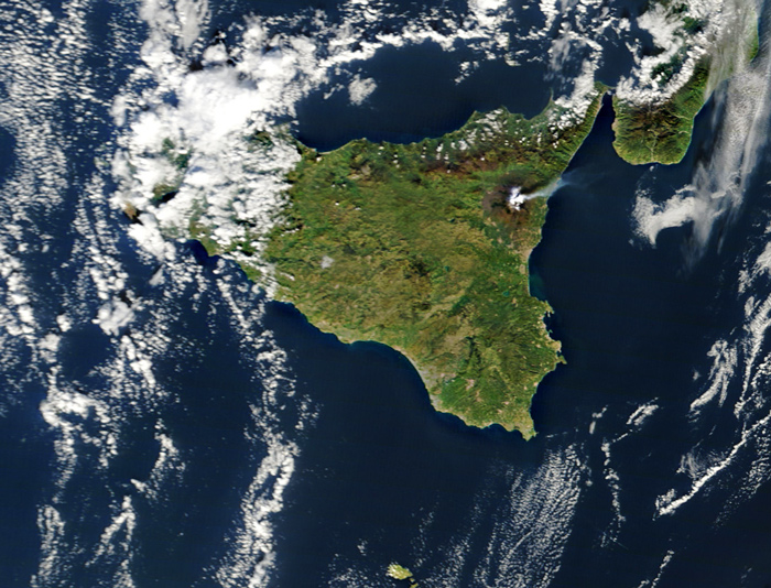 Right around this time last year, Mt. Etna in Sicily started doing this. Again.
birdseye view
volcano
Italy
satellite imagery
remote sensing
clouds
Mt. Etna
Sicily
Mediterranean
(Image credit: NASA MODIS satellite)
Jun 1, 2012
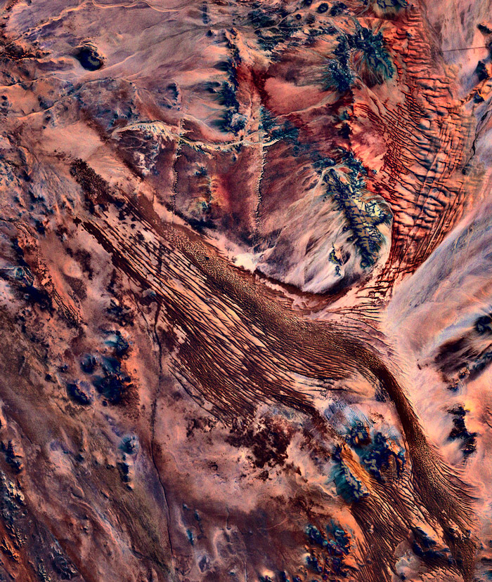 Southern Namibia, as seen from the Landsat 7 satellite orbiting 700 kilometers above the earth's surface.
birdseye view
Namibia
desert
satellite imagery
remote sensing
wilderness
(Image credit: NASA Landsat 7)
Feb 20, 2017
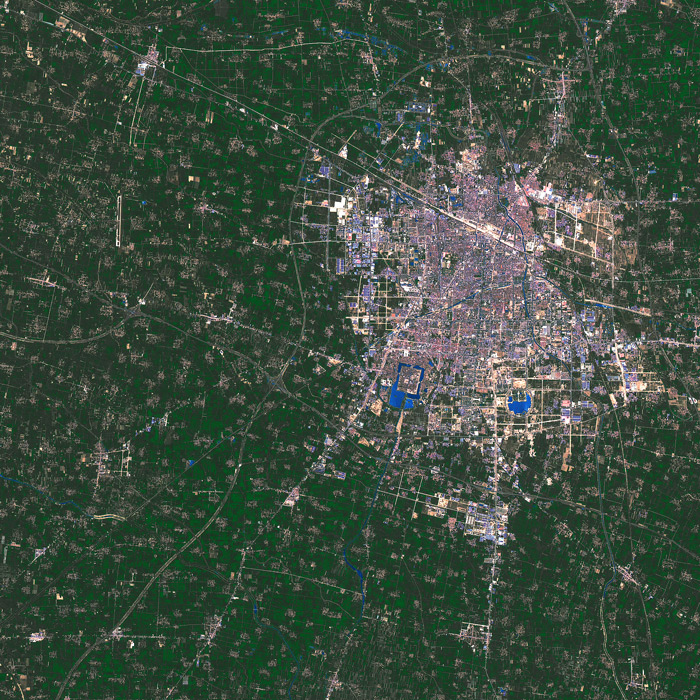 On the morning of May 13, 2016, NASA's Landsat 8 satellite collected thermal, infrared, and visible-light data from high above the city of Shangqiu, home to more than 1.5 million people in the midst of the wheat, cotton, corn and sesame fields of the North China Plain.
Shangqiu is a transportation hub, located at the junction of China's major north-south and east-west railroads. Also, the largest frozen-food processing company in China is headquartered there.
The lush agricultural land surrounding the city shows up as deep green in this image because Landsat's sensors are particularly sensitive to the vigorous plant growth characteristic of freshly planted fields in mid-spring.
The small brownish blotches in the farmland are agricultural villages. Almost 6 million people live in villages in the Shangqiu hinterland.
China
satellite imagery
springtime
farmland
North China Plain
Shangqiu
(Image credit: NASA Landsat 8)
 The first step in making sense of this image is distinguishing the two kinds of white stuff, clouds and snow. There's a big area of clouds over the Atlantic Ocean at the right edge of the picture, especially in the lower right, and another batch of clouds near the top of the image, streaming southeastward from Lake Ontario. The two cloud regions are connected in the upper right corner by a puffy little cloud bridge over . . . Portland, Maine. But that's irrelevant to the main point.