The Morning After
Jun 9, 2011
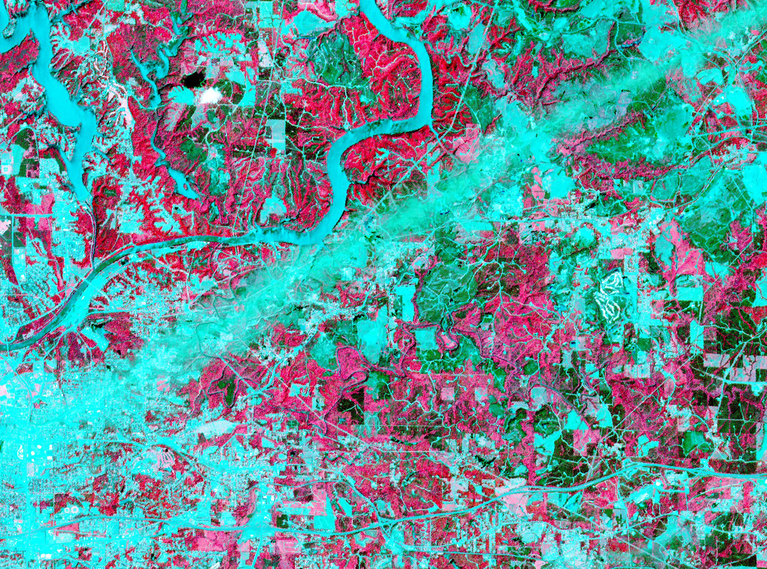 On April 28, 2011, the visible-light and infrared sensors of NASA's ASTER satellite captured this image of Tuscaloosa County, Alabama, which had been raked by an especially large and powerful tornado just the day before.
Infrared sensors are useful for distinguishing between vegetated and non-vegetated land cover. The pink areas in the photo represent vegetation–forests, pastures, cropland, golf courses. Areas that show up as aqua are non-vegetated or very lightly vegetated–cities, highways, rivers, strip mines, recent clearcuts.
The tornado track is obvious here: a straight aqua-colored streak running from the southwest to the northeast. Vegetation in this streak that was not directly destroyed by the storm was so littered with pieces of buildings and household objects that satellite sensors could barely detect it.
Just north of the storm track is the twisting course of the Black Warrior River, which shows up in aqua. The city of Tuscaloosa is mostly south of the river, at the left edge of the picture. In the upper left corner of the picture is Lake Tuscaloosa, a dammed-up tributary to the Black Warrior that provides the city's drinking water.
NASA's spokespeople assert that images such as this one can be useful in the aftermath of storms. They may help identify storm-damaged places outside of populated areas, where tornadoes might escape public awareness. And by proving the time and location of tornado paths, they could help homeowners support their insurance claims for storm damages.
If you click on the picture to see the larger version, you can follow numerous roads out into the countryside and observe that many of them seem to end with a little dot of aqua, indicating a non-vegetated spot. These are well pads for methane rigs. About fifteen years ago, the Black Warrior basin was the scene of one of the nation's first methane gas drilling booms. Coalfields underlie much of west Alabama, including almost all of Tuscaloosa County, but until recently the methane gas associated with coal deposits was considered a danger rather than an economically valuable fuel. "Fracking" technology, in which high-pressure liquids are injected deep into the earth to crack open the rocks hosting methane, was developed and refined in Alabama; drilling for methane is now under way all over the world. Unlike oil or traditional natural gas, methane is best extracted by small wells located within a few hundred feet of numerous other small wells; thus, the countryside is speckled with hundreds or thousands of separate well pads.