Hole in the Clouds
Jun 9, 2011
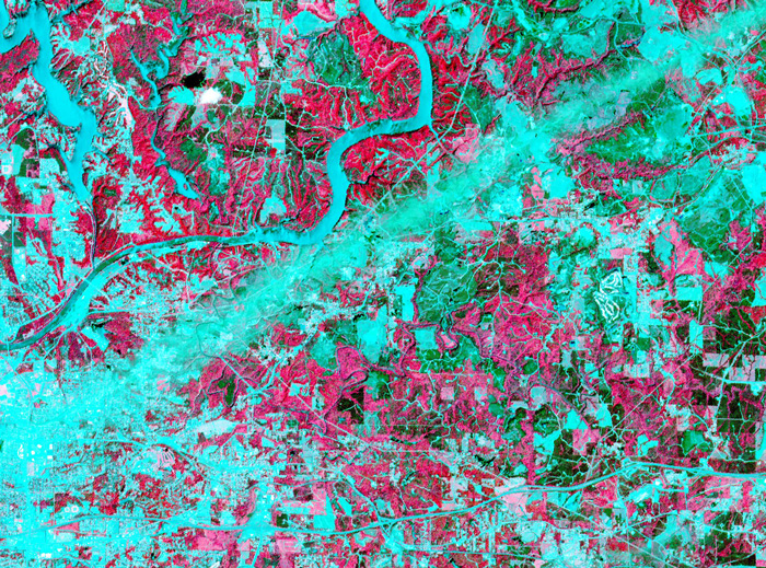 On April 28, 2011, the visible-light and infrared sensors of NASA's ASTER satellite captured this image of Tuscaloosa County, Alabama, which had been raked by an especially large and powerful tornado just the day before.
Infrared sensors are useful for distinguishing between vegetated and non-vegetated land cover. The pink areas in the photo represent vegetation–forests, pastures, cropland, golf courses. Areas that show up as aqua are non-vegetated or very lightly vegetated–cities, highways, rivers, strip mines, recent clearcuts.
The tornado track is obvious here: a straight aqua-colored streak running from the southwest to the northeast. Vegetation in this streak that was not directly destroyed by the storm was so littered with pieces of buildings and household objects that satellite sensors could barely detect it.
Just north of the storm track is the twisting course of the Black Warrior River, which shows up in aqua. The city of Tuscaloosa is mostly south of the river, at the left edge of the picture. In the upper left corner of the picture is Lake Tuscaloosa, a dammed-up tributary to the Black Warrior that provides the city's drinking water.
NASA's spokespeople assert that images such as this one can be useful in the aftermath of storms. They may help identify storm-damaged places outside of populated areas, where tornadoes might escape public awareness. And by proving the time and location of tornado paths, they could help homeowners support their insurance claims for storm damages.
If you click on the picture to see the larger version, you can follow numerous roads out into the countryside and observe that many of them seem to end with a little dot of aqua, indicating a non-vegetated spot. These are well pads for methane rigs. About fifteen years ago, the Black Warrior basin was the scene of one of the nation's first methane gas drilling booms. Coalfields underlie much of west Alabama, including almost all of Tuscaloosa County, but until recently the methane gas associated with coal deposits was considered a danger rather than an economically valuable fuel. "Fracking" technology, in which high-pressure liquids are injected deep into the earth to crack open the rocks hosting methane, was developed and refined in Alabama; drilling for methane is now under way all over the world. Unlike oil or traditional natural gas, methane is best extracted by small wells located within a few hundred feet of numerous other small wells; thus, the countryside is speckled with hundreds or thousands of separate well pads.
Tuscaloosa
Alabama
birdseye view
infrared
satellite imagery
tornado
methane
fracking
(Image credit: NASA ASTER satellite)
(h/t: Chuck Horowitz
Aug 17, 2011
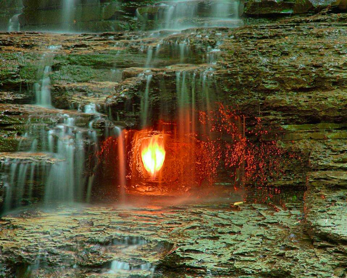 History has not recorded the name of the first person to light a fire in the little grotto behind the waterfall in Shale Creek gorge, now part of Chestnut Ridge Park recreation area in Erie County, New York, near Buffalo.
Despite the name of the place–Eternal Flame Falls–neither the flame nor the waterflow is perennial. Shale Creek is an intermittent stream, drying up to a trickle except during snowmelt and days of very heavy rain. The methane gas that fuels the flame is always present–it is produced by rotting vegetation trapped in the shale, and it bubbles up through fissures at several places along the creek, notably into a natural alcove large enough to keep the flame dry behind the watery curtain of the falls. But the flame does go out sometimes, if the wind is gusty or the waterflow especially drenching.
The greenish-gray rocks here are part of a formation called Hanover Shale, roughly 380 million years old. Where this shale is at or near the surface, as here, any gas it contains will simply ooze out into the atmosphere, making it economically worthless; in places where the Hanover Shale is buried deep underneath other rocks, however, its gas is trapped under great pressure and may be worth drilling for.
New York
methane
Erie County
waterfall
gas
Shale Creek
Chestnut Ridge Park
(Image credit: Carl Crumley)
Mar 17, 2016
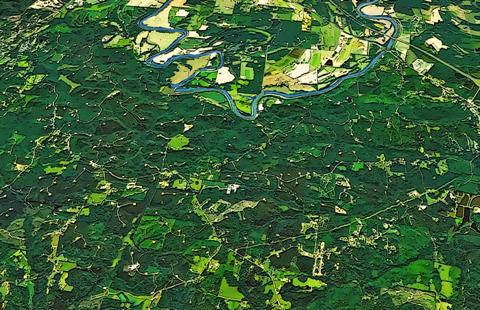 Southwest of Tuscaloosa, near the small town of Moundville, Alabama, the meandering Black Warrior River twists and turns through mostly forested countryside. In this rendering based on satellite imagery, there are little white dots scattered everywhere in the trees and the fields; each dot is at the end of a little spur of road.
These are drilling pads for methane wells.
Methane is the gas that sickens canaries in coal mines. It's what all too frequently makes underground mines explode; wherever there's coal, there's methane. Commercial extraction of coalbed methane, to be sold as natural gas, began in the early 1980s, and the Warrior basin of Alabama was scene of the world's first methane boom; to maximize production quickly, wells were drilled every few hundred feet throughout the region.
After a very few years, the boom went bust. Most wells now sit idle, and many have been orphaned, leaving the cleanup and decommissioning expenses to the taxpayers.
But you can still see the little white dots on the landscape, even from space.
Alabama
methane
Black Warrior River
coalbed
drilling rigs
meanders
Moundville
 On April 28, 2011, the visible-light and infrared sensors of NASA's ASTER satellite captured this image of Tuscaloosa County, Alabama, which had been raked by an especially large and powerful tornado just the day before.
