Hole in the Clouds
Aug 3, 2009
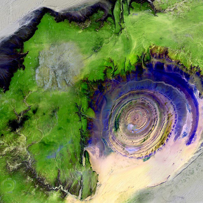
This rock formation, known formally as the Richat Structure and widely as the Eye of Africa, sits at the southern edge of the Sahara desert in Mauritania. It's a favorite of the astronauts looking down on us, and also a favorite of students of Landsat satellite imagery. It's not a meteor crater or a volcano, but a sedimentary rock formation, layer upon layer of tough, resistant sandstone, brought into sharp relief by softer mudrock that is eroding away. The reason for its perfectly round shape is . . . not well understood.
This image incorporates infrared energy as well as light from the visible spectrum, so the colors are not natural. But twhen the sun is shining on the Sahara Desert as the astronauts sail above it, they do see the Eye of Africa as blueish.
Richat Structure
Mauritania
infrared
(Image credit: NASA Landsat 7)
Oct 3, 2009

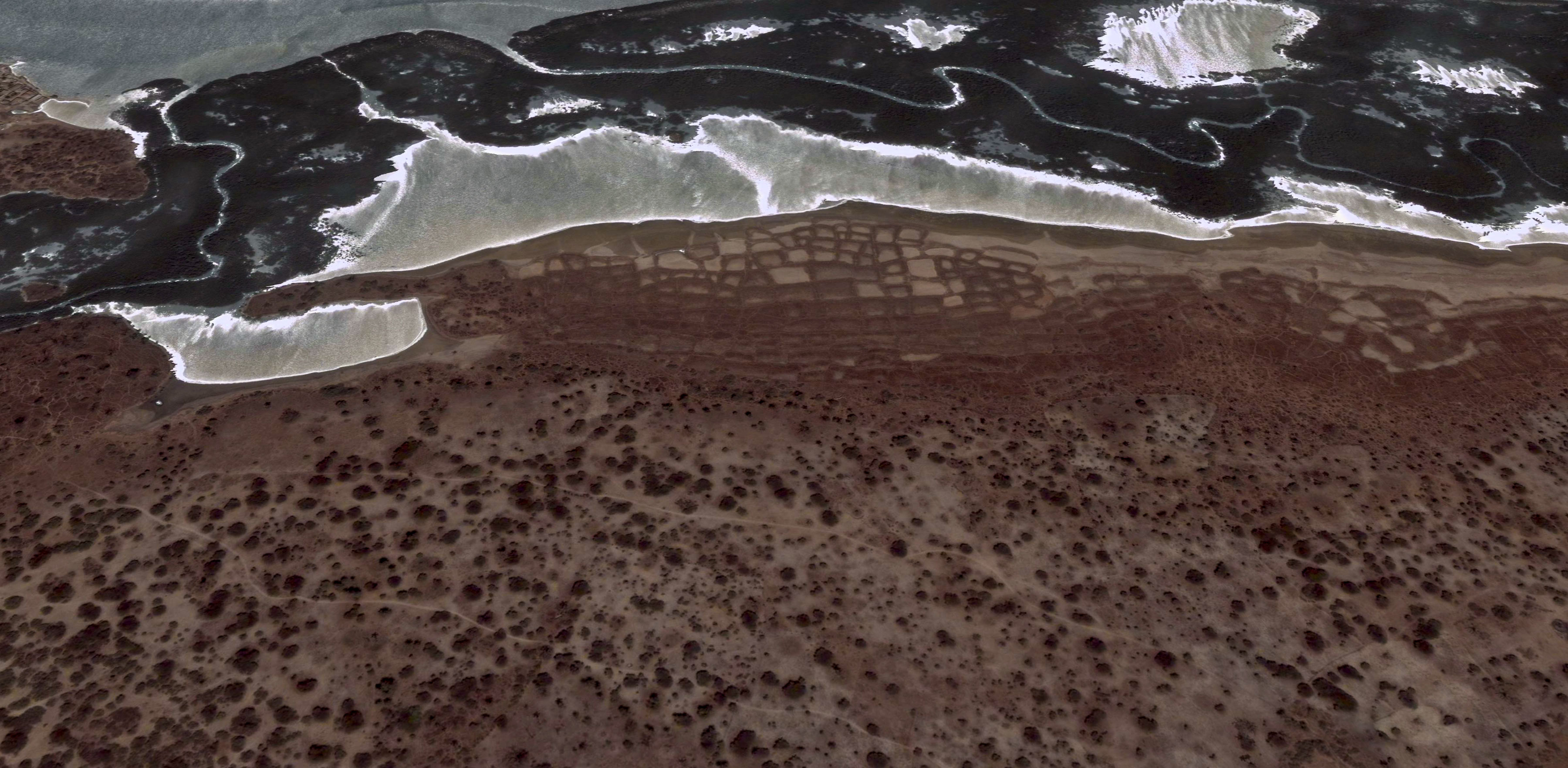
The Atlantic coast of Senegal near the mouth of the Gambia River, as perceived by the sensors of the Landsat 7 satellite.
landscape
beach
Senegal
birdseye
Atlantic
(Image credit: NASA Landsat 7)
Nov 14, 2009
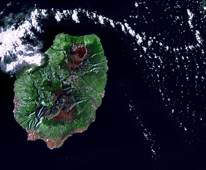
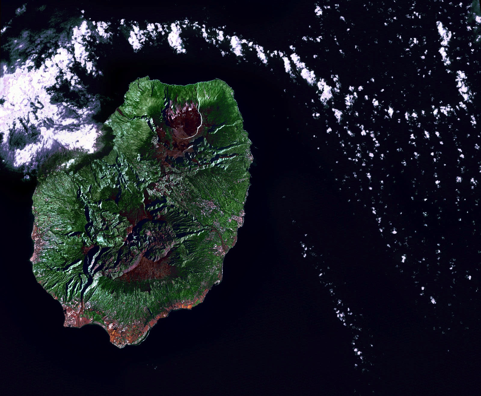
Early in the morning of June 19, 2002, the Landsat 7 satellite swooped across the Indian Ocean and snapped this picture of Reunion Island. The volcano there, Piton de la Fournaise, was quiet that day--the clouds in the picture are just clouds, passing by.
Geologically, Reunion is virtually a twin to Hawaii halfway around the world, a huge shield volcano above an oceanic hotspot. It has been one of the most active volcanoes in the world throughout modern history, erupting almost every year, sometimes more than once, since 1670. The whole island is made of basaltic lava; it's the tip of a volcanic monster mountain rising from the ocean floor. All over the island are volcanic vents, cones, craters, and large calderas, where lava domes exploded and collapsed. The caldera that is currently most active, toward the top of this picture, has slumped down all the way to sealevel at the coast.
Basaltic rock weathers to make rich soil, and here as in Hawaii the climate encourages lush vegetation. New lava doesn't remain bare rock for long.
Politically, Reunion is part of France; because of its time zone far to the east of Europe, the euro became legal currency here a few hours before it did anywhere else. Eight hundred thousand people live on the island.
birdseye view
geology
Reunion Island
Indian Ocean
volcano
(Image credit: NASA Landsat 7)
Oct 22, 2010
If you drop the first two letters of the name of the nation of Mexico, you get Xico, the name of several towns and landmarks around the country. There is, for example, the small hill town of Xico near Veracruz, where it is said that people do very little besides growing coffee and hosting bullfights. And here we see two other Xicos: a volcanic crater and the fast-growing city that surrounds it.
Xico volcano sits at the extreme southern end of the Mexico City megalopolis. For a geologically significant chunk of time, this area was underwater, drowned by Lake Chalco. The lake began to dry out in the 1300s, and Aztec fishermen settled along its coastline hereabouts. In the nineteenth century, the government drained the lake entirely; the fishermen were awarded communal land grants and told to become farmers.
Farming became intensive in the 1970s, when corporate agriculturists and desperate landless peasants struck illegal or quasi-legal deals with the communal organizations and wrested control of the rich volcanic soil. Thousands and thousands of families poured into the region, hoping for work. Farmers climbed over the rim of the volcano and plowed fields inside the crater. Xico the town sprawled right up to the ramparts of Xico the crater and appears likely to soon engulf it; in 2005, the population of the municipality was 330,000.
The urban fringes seen here lack the services and amenities taken for granted twenty miles away in downtown Mexico City. Xico's roads are mostly unpaved, schools are few and far between, and the people are almost all very poor. Now that NAFTA has dismantled the remains of the communal farming system, it seems to be increasingly the case that even the rich volcanic soil here in Xico is worth more as slumland than as cropland.
landscape
birdseye view
volcano
Mexico
satellite imagery
remote sensing
(Image credit: NASA Landsat 7)
Dec 1, 2011
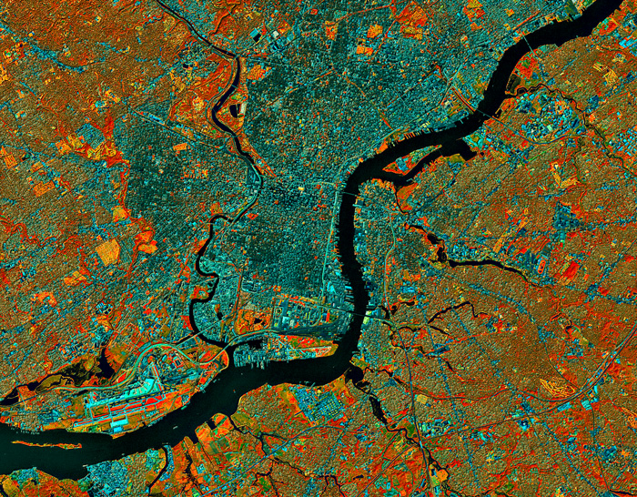 At about 9:30 in the morning on September 23, 1999, the Landsat 7 satellite swooped southward over eastern North America and captured this image of Philadelphia and environs.
Three of the Landsat sensors detected energy in the infrared part of the electromagnetic spectrum, completely invisible to the human eye. Data from these sensors is displayed here, with each of the three infrared bands assigned to one of the normal red-green-blue color bands so we at least have something to look at, even though the colors have nothing to do with normal vision.
Clicking on the picture brings up a bigger version, which shows much more detail.
We can tell right away that the rivers are black; infrared energy is completely absorbed by water, reflecting back nothing for the sensors to detect. And if we look along the river at lower left, we can make out the airport, with runways that are bright cyan in color. This white-to-bluish hue is also the color of roads, railroads, parking lots, and other paved surfaces.
Infrared data is especially useful for studying vegetation, which shows up in this color scheme as red, orange, or yellow. The brightest red patches represent vigorous herbaceous growth, such as healthy cropland in the midst of the growing season. There's little or no farmland in and around Philly, however, so the red patches we see here, such as in between the airport runways, are probably healthy weeds.
Patches of red coloration with a touch of an orange tint and some texture are forested areas, such as in parks or between the fairways of golf courses. Extremely vigorous grass, such as on the golf course fairways themselves, looks bright yellow in this view.
The brownish-to-grayish-to-bluish areas show mixed land cover: Landsat's sensors are averaging out the infrared signals from house roofs, pavement, lawns, shrubs, and trees in varying concentrations. Brownish areas are suburban, with lots of trees and grass; dark green to gray-blue areas are more urban, with a higher ratio of rooftops and pavement to vegetation.
Philadelphia has changed since this image was captured twelve years ago. Another stadium has been built near where the Schuylkill River empties out into the Delaware. In my neighborhood just south of Center City, the forested patch of land near the Schuylkill, which in 1999 was an abandoned and overgrown Old Sailors' Home is now a heavily developed condo complex. Even though the population of Philadelphia has shrunk dramatically over the past half-century and has just barely started growing again, land use patterns as viewed from outer space show ongoing urbanization.
Pennsylvania
birdseye view
infrared
Philadelphia
city
airport
Landsat
bands 457
rivers
refinery
(Image credit: NASA Landsat 7)
Jun 1, 2012
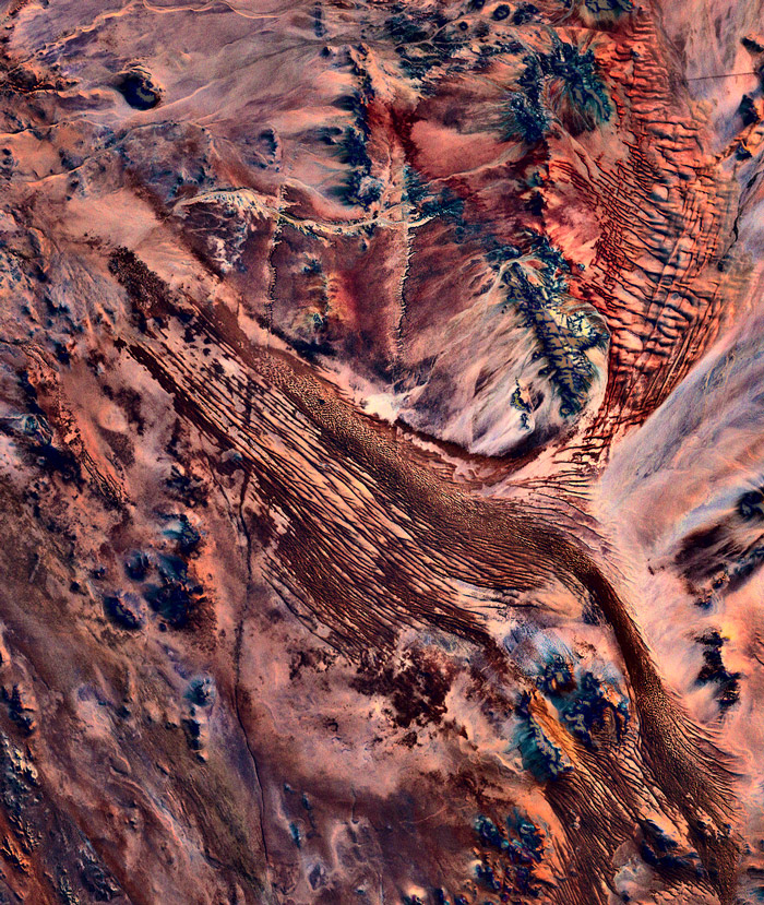 Southern Namibia, as seen from the Landsat 7 satellite orbiting 700 kilometers above the earth's surface.
birdseye view
Namibia
desert
satellite imagery
remote sensing
wilderness
(Image credit: NASA Landsat 7)