Hole in the Clouds
Aug 19, 2009
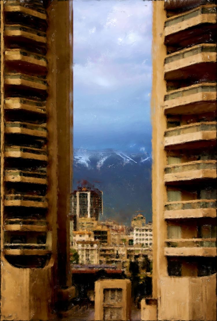
In 2004, Iranian-Canadian photographer Sam Javanrouh went back to Tehran, his hometown, for a photo shoot. Here, he shows us Tehran's Eskan towers framing a glimpse of the Alborz Mountains. "Brings back so many memories," says Javanrouh.

Tehran
mountains
Iran
cityscape
Sam Javanrouh
(Image credit: Sam Javanrouh)
Nov 19, 2009
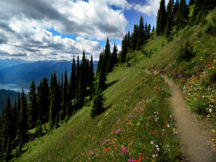
About twelve summers ago, we made it to Idaho Peak, above New Denver, British Columbia, in the Selkirk Mountains. That meadowful of flowers up there is as good as it gets for flowers.
The trail isn't as sketchy as it might look; it meanders gently around the bend up ahead toward a fire tower that overlooks Slocan Lake and the tiny lakeside towns of Silverton and New Denver. All the settlements in this neck of the woods were late-nineteenth-century mining towns; when the silver and gold gave out in the early to middle years of the twentieth century, the towns struggled, and some vanished. A revival began in the 1960s with U.S. draft dodgers and Canadian and U.S. back-to-the-landers, who were attracted by the scenery and the lack of twentieth-century sprawl.
Best thing about the flowers on Idaho Peak: it's always summer up there. The flowers are always in full bloom. I can't remember it any other way.
landscape
Canada
mountains
summer
Idaho Peak
New Denver
British Columbia
Slocan Lake
flowers
(Image credit: Z Vickery)
Jan 28, 2010

A few months ago, the New Zealanders among us were out touring their island--New Zealand's North Island--when they stopped for the night at the Okopako Farm Lodge in Opononi, Northland, a backpackers' hostel at the end of a primitive gravel road--a road so narrow and winding and twisty, we're told, that it can't be driven after dark. The people who run the lodge, which is off the electrical grid, offer "fresh organic produce, homemade bread & farmhouse meals," and they also promise a nice view.
This is what dawn looks like from the deck of the lodge.
"I shot photo after photo," recalls A., "as the sun rose. Unfortunately, I was so engrossed in the scenery I left bread on a burner on one of those camp toasters until it thoroughly burned, and its blackened remains released a massive amount of smoke that set off the fire alarm. The fire alarm rang for about 20 minutes, which did not thrill the few other inhabitants of that place.
"The upside was that they were awakened in time to enjoy the sunrise, too."
landscape
New Zealand
mountains
birdseye view
Opononi
Northland
dawn
(Image credit: A
at happy to be here)
May 19, 2010
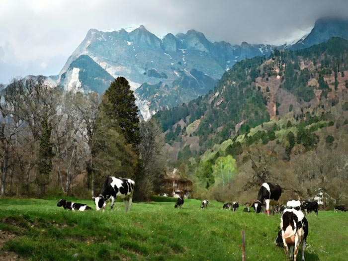
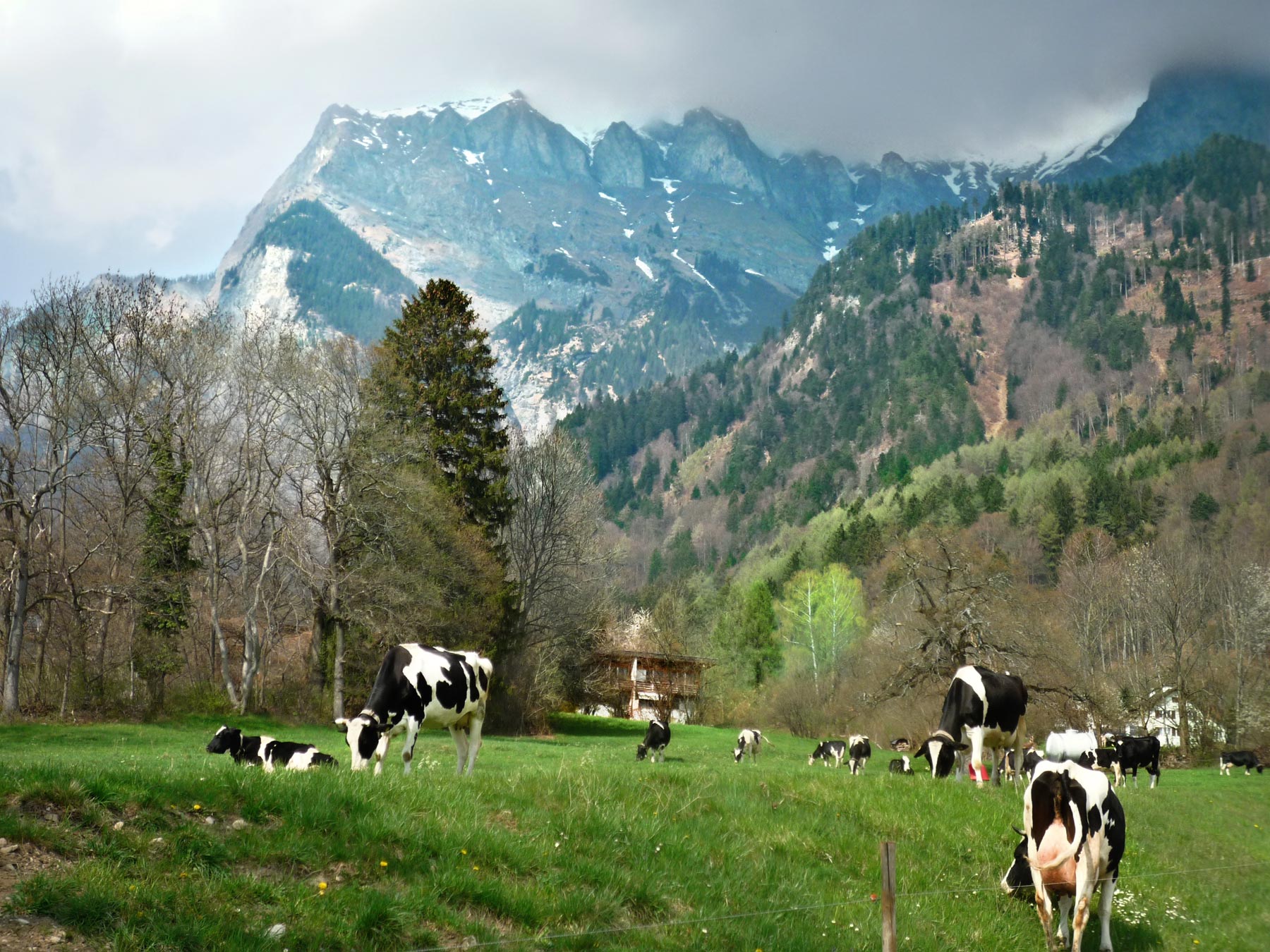
You may recall that it was in the mountains here above the village of Maienfeld, Switzerland, that Heidi and Peter used to take the goats to pasture. The cows, which didn't really figure in the Johanna Spyri novel or in the Shirley Temple movie, presumably stayed down below in these pastures in the Rhine River Valley. Heidi and Peter climbed up the goat paths every morning, frolicked in the meadows, and lived happily ever after in the bright clean air, curing the invalid Clara, bringing the old hermit back to the church, and spreading joy and good cheer and etc.--even so, it was a nice book, a nice movie, and there's no denying it's a beautiful piece of the world.
Today the people of Maienfeld mostly tend vineyards and host tourists looking for Heidi. An hour's walk up the valley is the spa town of Bad Ragasz, where tourists come looking for Roger Federer.
landscape
mountains
cow
Heidi
Switzerland
(Image credit: Katrin Maldre)
May 22, 2010
Something I learned today about the oil gushing into the Gulf of Mexico from BP's blown-out well got me thinking about all the oil that didn't get away, the oil that BP and the other companies have managed to pump and sell over the past century or so, without "wasting" much through spillage.
What I learned from TV news this evening was that one reason BP has sought to downplay the amount of the Deepwater spill is that the company will likely have to pay agreed-upon royalty fees to the government for every gallon sucked out of the earth, including all the gallons spilled into the Gulf. Of course, when BP signed that contract, it was planning to harvest all the oil, not let millions of gallons of it float away.
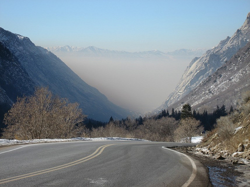
And what about the oil that gets pumped up properly, refined, delivered to gas stations and power plants and heating oil companies, and eventually sold to us customers. What do we do with it? We burn it, of course (except for the portion we use to make plastic). Some small amount of residue from the burning gunks up our cars' engines and catalytic converters and slimes up the surface of our roads, but modern cars burn fuel pretty efficiently; the vast majority of what was gasoline when we paid for it goes out the tail pipe and into the air. You can see the oil in the air in this picture, which shows the view from the Wasatch Mountains of Utah, looking westward toward Salt Lake City. The exhaust from a few hundred thousand cars has become thick smog, completely hiding the city.
The twentieth century was the age of oil; Saudi Arabia's wealth was discovered in 1900. By approximately 2000, we'd burned up half of all the oil believed to exist, including almost all the oil in Texas and Oklahoma and most of the oil in Alaska. Much of that century's worth of oil smoke is still in the air, doing its greenhouse-gas thing, but much has fallen back to earth by now, often washed out by rain and snow. We say that a rain shower has "cleared the air," and it has. Back on the ground, the chemicals that perhaps recently floated in the air as smog and once upon a time rested deep underground as oil now leach down through the soil into our groundwater or wash directly into creeks and lakes and rivers and of course oceans. Either way, we drink that oil. And it's nasty--carcinogenic and flat-out poisonous.
All day every day, we drink oil and breathe it; after a century of oil-burning, we and all the other plants and animals on the planet probably have traces of oil in every cell in our bodies. A century is a very short time, evolution-wise; homo sapiens evolved in a world where almost all the oil was trapped deep underground, and hardly any of it was in the air and the water and the food chain.
We've been able to eat and drink and breathe oil and still get by, so to speak, because most of the time the burnt-up oil is diluted before we ingest it. The life in the Gulf of Mexico won't be so lucky.
smog
landscape
mountains
Wasatch Mountains
Utah
Jun 23, 2010
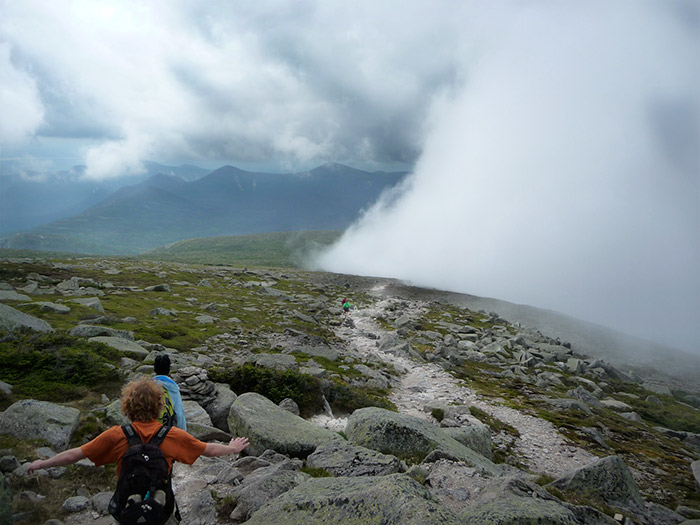
Members of Deering High School's Outdoors Club head back down the hill and into the weather after summiting mile-high Mt. Katahdin recently, the highest peak in Maine and northern terminus of the Appalachian Trail.
As they followed the trail on down into the clouds, they got rained on but good. Fortunately, their youthful high spirits proved to be waterproof.
landscape
Maine
mountains
Mt. Katahdin
(Image credit: Hank Stein)
Mar 1, 2011
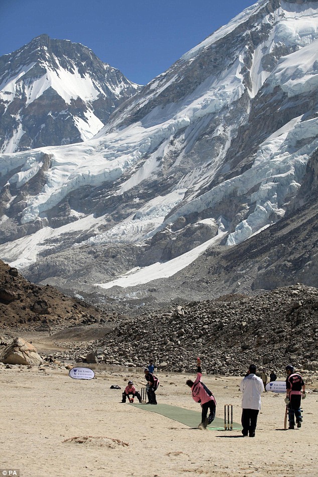
It is obvious to some people that Nepal's Gorek Shep plateau--the world's highest sizeable plateau, abutting Everest Base Camp at 5,165 meters above sea level--is shaped exactly like London's famed international cricket ground, the Oval.
British mountaineer Richard Kirtley, for example, took one look at the Gorek Shep and concluded that it was so "perfectly cricket-field sized and shaped" that "the locals" must be using it as a pitch. He was wrong; nobody ever played cricket there, presumably because few people remember to bring their cricket gear along for nine extremely arduous days of trekking en route to Everest Base Camp.
But some people really like cricket. Kirtley organized a 50-man expedition that trekked to Gorek Shep in April 2009, cleared the pitch of rocks ("sometimes with pickaxes"), and contested the world's highest game of cricket, the Nokia Maps Everest Test. Team Hillary beat team Tenzing by 36 runs, with 6 balls remaining.
I wouldn't know a cricket pitch if it jumped up and bit me, and I am way too old and timid and out of shape to imagine venturing to Everest Base Camp. Still and all, I'm leaving for Nepal in a couple of days, and I'll be away from the computer and off trekking till the middle of March. It was my sister's idea, and also her frequent flyer miles. Details and pictures to come.
Be sweet while I'm away.
landscape
mountains
Nepal
Richard Kirtley
trekking
Mt. Everest
cricket
Hillary
Tenzing
Mar 23, 2011
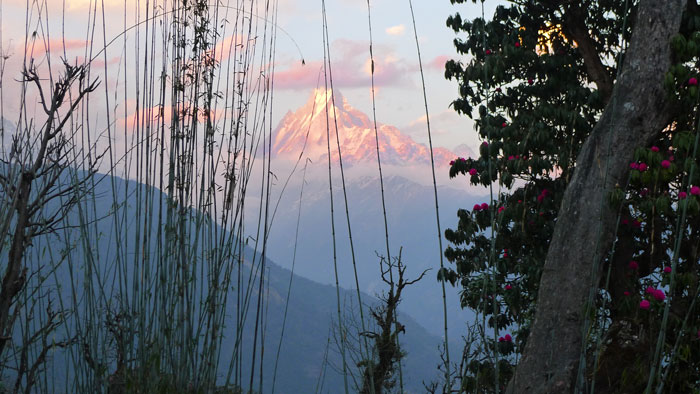 I had hoped that our days on the trail in the Himalayan foothills would include views like this, and such expectations were fulfilled many times over. This is Machhapuchhre–Fishtail–a holy mountain that no one is allowed to climb. The flowering tree is a rhododendron, Nepal's national flower, which was just coming into bloom in early March.
But the scenic vistas were really the least of the experience. Nepali footpaths are essentially highways for the villagers who live in the hills; they have no railroads, no cars or trucks, certainly no airports, so if they want to order a little refrigerator from town and bring it home, somebody will have to walk up the trail with the refrigerator on his back.
If they want to bring a squawking chicken to a nearby village, somebody will have to tuck it under her arm and walk with it. If they want to bring in sacks of rice, or buckets of sheetrock, they will have to load up a donkey caravan and walk behind it with a loud voice and a big stick. They may have to walk for days and days and days, first on the floor of the valley, trudging upstream alongside a river, and then steeply up the side of the hill, on a rocky staircase of sorts built up over the centuries with rocks pried loose from the soil of terraced hillside fields and vegetable gardens.
One of these staircases had more than 4,000 steps–think four or five Empire State Buildings on top of one another. More of which to come.
The villages are agricultural in character, but they all have commerce now, thanks to the trekking trade. Restaurants feed the visitors, souvenir stands sell them stuff, and lodges put them up for the night–accommodations are "basic," with outdoor facilities, but tourists don't have to carry their own tents or food. To feed us trekkers, somebody from the village walked down the hill with an empty basket on his or her back and then walked back up again with a basket full of bottled water and other Western goodies. Nepalis don't use backpacks; they carry even the heaviest loads with the aid of straps across their foreheads.
At least one inn in every village is called Shangri-La. Rooms go for about 200 rupees–$3–a night.
landscape
mountains
flowers
Nepal
trekking
Ghorepani
Apr 4, 2011
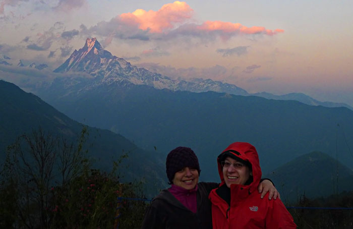 After walking three days uphill from the nearest road, my sister and me, we reached Ghorepani, which as you can see is just one little valley over from the sacred mountain called Fishtail. We'd started out in subtropical rice-and-banana-growing country and climbed up into just-barely-spring-with-patches-of-snow-and-ice country.
I am blessed with a sister who can make this sort of thing happen, who can move Himalayas if necessary to get stuff done. If the arrangements had been left up to me, I'd probably still be sitting at home fretting over the possible significance of Nepal's time zone (15 minutes ahead of India). I really, really lucked out in my choice of a sister.
landscape
mountains
Nepal
Ghorepani
Ellen
Himalayas
Carol
Fishtail
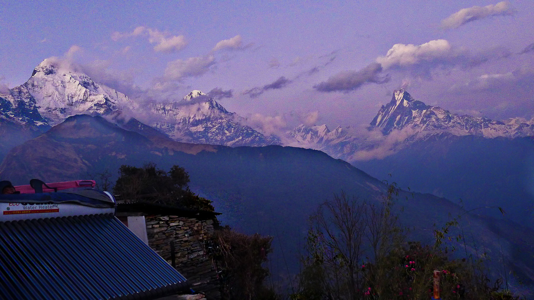
Apr 14, 2011
 At 26,040 feet (8091 meters), the summit of Annapurna, tenth highest mountain in the world, is more than half a mile lower than the peak of Everest. Even so, Annapurna is the most dangerous mountain in the world to climb; only 153 climbers have ever made it to the top, and 58 have died trying.
Annapurna is a huge massif with five major peaks. Here, at left above the village of Ghandruk and its green fields of millet, is Annapurna South, elevation 23,684 feet (7219 meters). The spur to its right, known as Himchati, just under 23,000 feet high, was first climbed in the 1960s, by a Peace Corps volunteer stationed in Nepal.
The name Annapurna is Sanskrit; a literal translation is "full of food," or "well-rounded." It is associated traditionally with the feminine form and with goddesses of the kitchen and the harvest, and more generally with Lakshmi, Hindu goddess of wealth.
The rightmost mountain in the picture above is Machhapuchhare–Fishtail–sacred to the god Shiva and off-limits to climbers. It has never been summitted.
The village Ghandruk is a day's walk uphill from the nearest road, including a climb up a staircase containing–if the trail sign is to be believed–more than 8,000 stone steps. My sister struggled diligently to keep count but could neither confirm nor disprove the official number. I was much too winded to try anything as complicated as counting; all I could do was huff and puff and sweat and whine.
Ghandruk is a village of Ghurkas, the renowned warriors. Military service has entitled some of the Ghurkas to emigrate to Britain or to work in such far-flung places as Singapore, and it is said that the village's main source of income is remittances from abroad. One man told us his son was working as a policeman in Singapore; he also told us that in Ghandruk his son went by the name "Big Sexy."
A day's walk uphill from Ghandruk is a village called Tadapani, where Annapurna seemed much bigger and closer (below). The solar water heater on the roof of our inn was working fine, but there were way too many of us hoping for hot showers. We saw solar heaters and panels all over Nepal, even in places where poles and wires brought in power from the grid.
Also, everywhere we went, even in Kathmandu with its three million inhabitants, the practice of "load sharing" shut down the electricity every few hours. We were told that outages were according to schedule and that a schedule for the coming week could be read in the newspaper, but we never saw a schedule and were always caught by surprise.

landscape
mountains
Nepal
Ghandruk
Himalayas
Tadapani
village
May 3, 2011
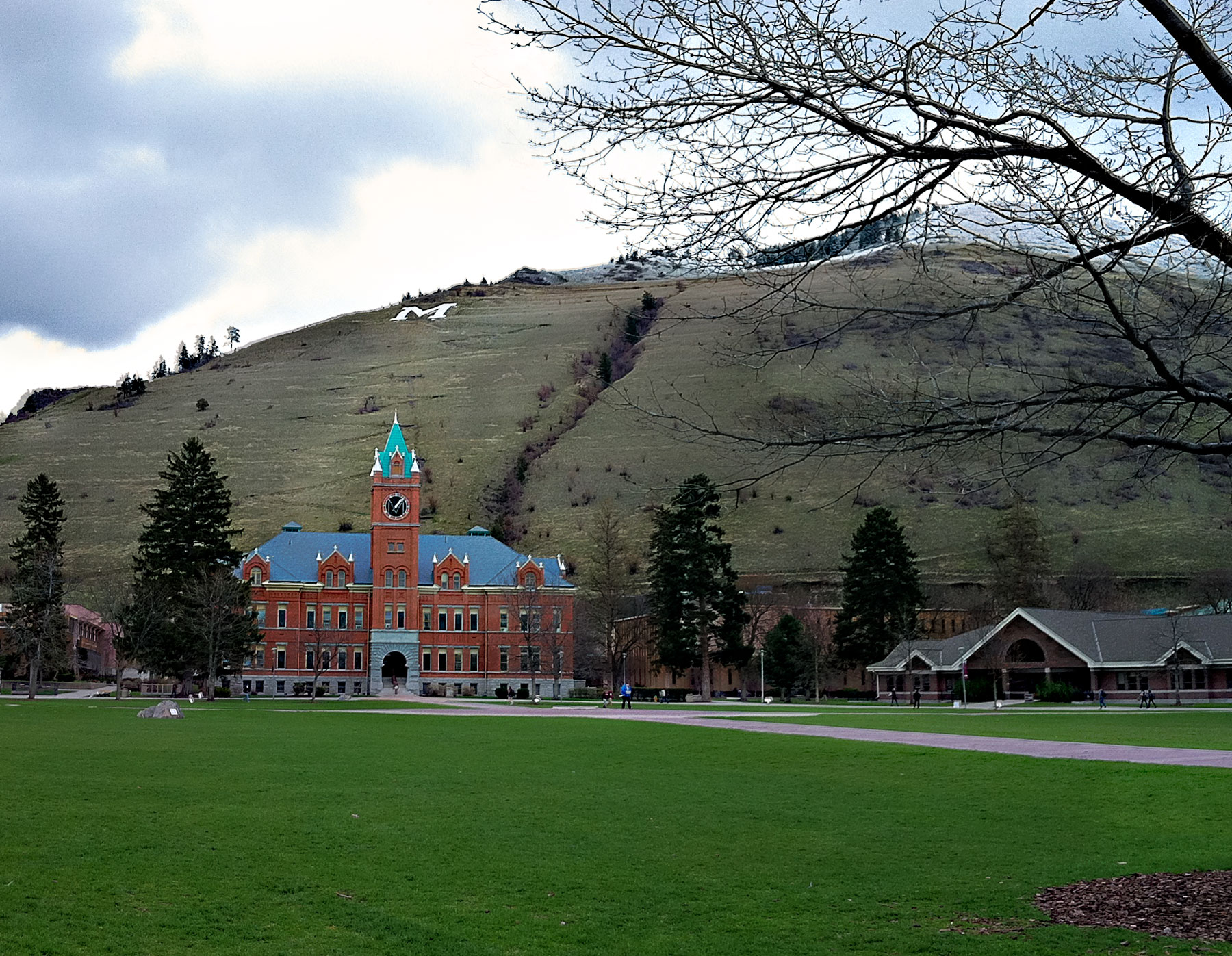
 The snowline has retreated most of the way up the hillside above the campus of the University of Montana in Missoula, and the well-tended campus lawns have turned seriously green.
Still, the sky sometimes spits snow, and the trees daren't yet display a hint of green. If on some afternoons the spring air is gentle enough to warm an upturned face, you can take it to the bank that a few minutes later the wind will stir and whip and sting, and push the people back indoors.
Must be May in Montana.
landscape
mountains
spring
University of Montana
Missoula
Montana
May 6, 2011
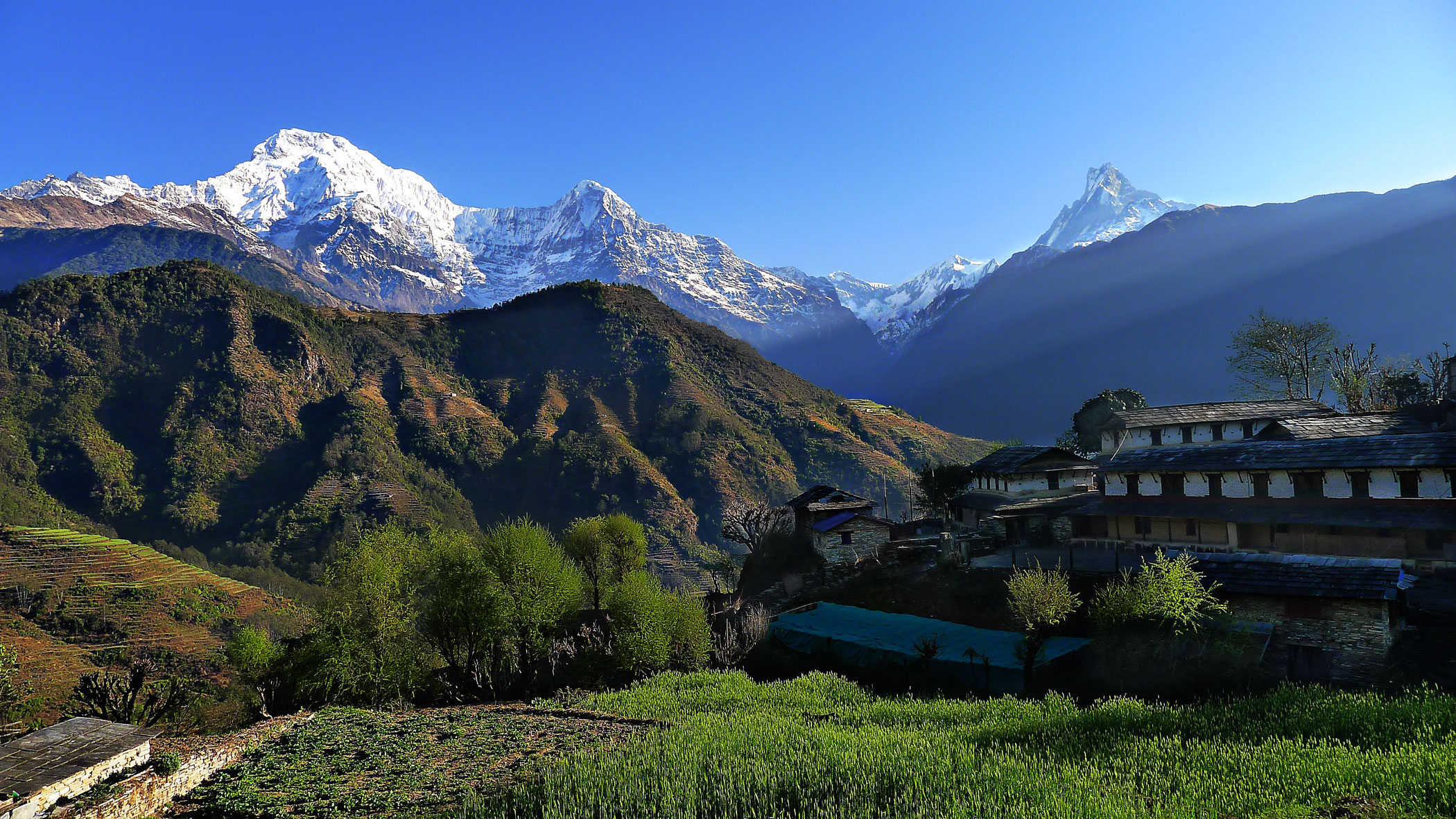
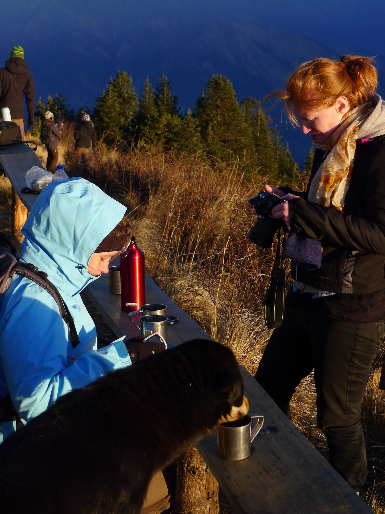
 About a thousand feet straight up above the village of Ghorepani in Nepal's Annapurna region is the crest of Poon Hill, a vantage point where trekkers from around the world gather at dawn to watch the sun rise over the Himalayas.
Poon Hill is 10,500 feet above sea level, and it's cold there at dawn. Well before dawn, enterprising citizens of Ghorepani make huge vats of hot tea and carry them up the trail to sell to the trekkers. Here, a local dog shares a trekker's cup of tea.
Dogs are ubiquitous in Nepal. In the countryside, most of them look just like this one–medium-sized, square-headed, with a thick black coat and light tan markings. In the city of Kathmandu, the dog population exhibits more variety, but they still tend to be medium-sized, square-headed, and thick-coated. Dogs can be seen sleeping in the sun on sidewalks and streets all over the city. They live off garbage and scraps tossed out the back of restaurants and homes. They show no aggression toward humans and only a little toward other dogs; none of them, of course, is on a leash. Mostly, they sleep.
dog
mountains
Nepal
trekking
Himalayas
Poon Hill
May 17, 2011
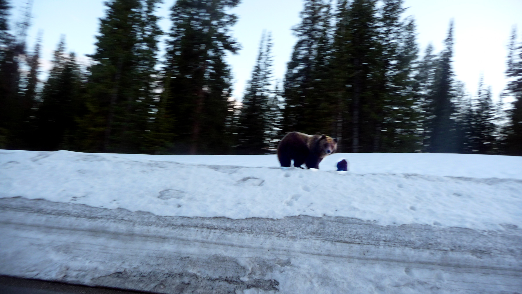
 On Highway 26 the other day, just outside of Dubois, Wyoming, in the Wind River Range, this grizzly and her cub crossed the road and scooted up the snowbank while Hank tried to snap her picture.
The snow thereabouts was still four feet deep in mid-May, which is why Hank and his friend Pat found themselves scurrying along Highway 26, south of Yellowstone, on their way back east from Montana. All over Yellowstone and the Tetons, late spring avalanches were closing highways, and the boys found their way blocked repeatedly; they backtracked, looped southward, backtracked again, looped further south, and finally broke out onto the plains.
mountains
animals
snow
bear
Wyoming
Wind River Range
(Image credit: Hank Stein)
Jun 7, 2011
 At the University of Montana, students can earn academic credit for assignments like this. Hank got an A last semester in Intermediate Rock Climbing.
sports
landscape
Hank Stein
mountains
rocks
rock climbing
Montana
Jul 6, 2011
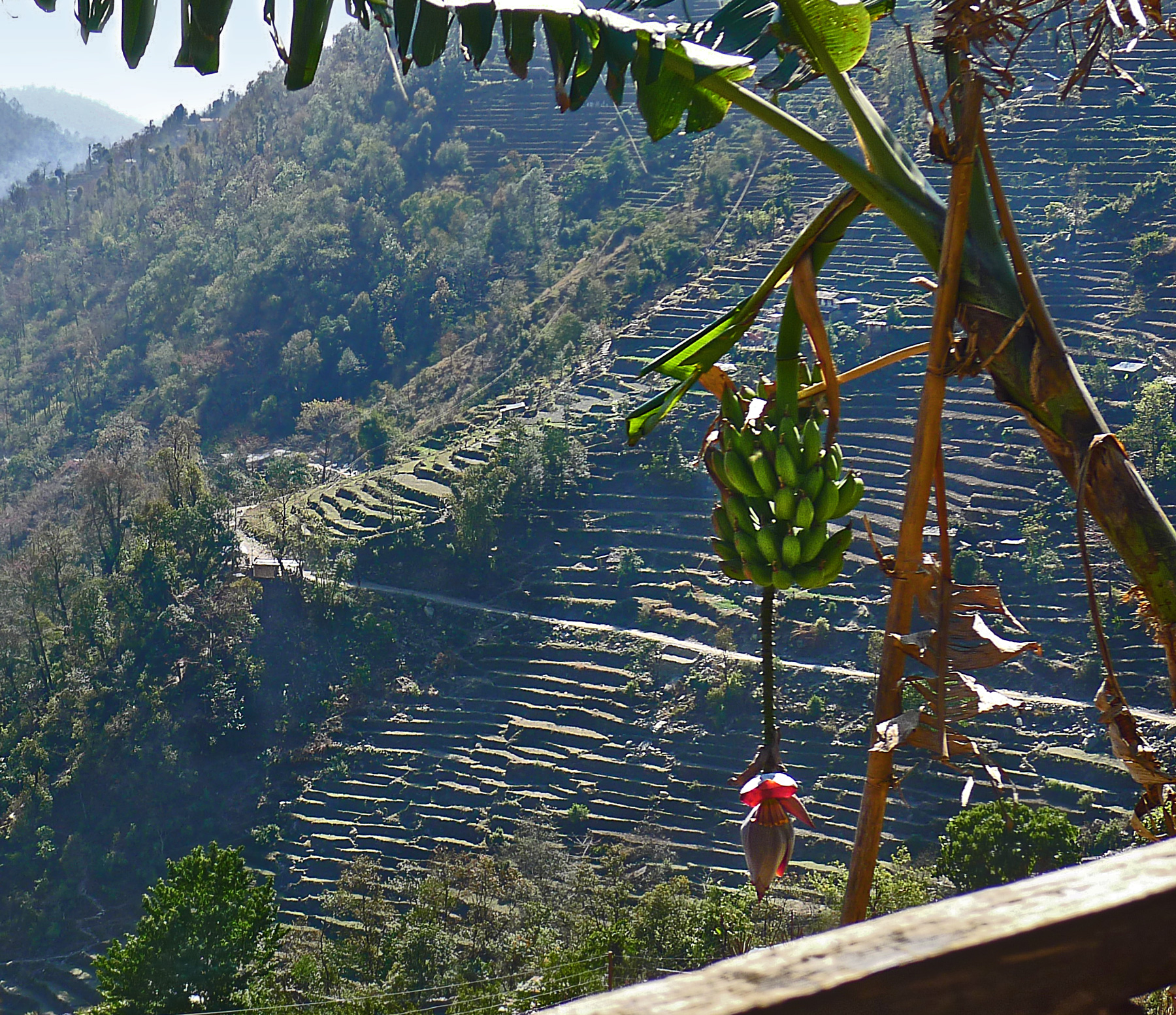
 The valleys and lowermost hillsides of Nepal are subtropical; the crops grown there include tea and coffee and these banana trees. If a sturdy trekker were determined to leave the subtropics behind, he or she could walk straight uphill from here into patches of spring snow in a few hours, and into the glacial icefields of the high Himalaya in a few days.
Global warming is spreading up the mountainsides. Nepalis hope they have figured out a way to make money on climate change; the increasing heat in the air that has reduced productivity of tea plantations in India seems to have permitted tea cultivation higher than ever before on Nepalese hillsides. Not all the new plantings have thrived–the air is thinner in the high mountains, and the soil is rocky and poor. But fine tea is coming out of Nepal these days, from slopes about a mile higher than the bananas shown here.
In the long run, of course, tea won't save Nepal. As the glaciers shrivel in the high mountains and a scanty winter snowpack produces less and less spring runoff for the rivers of the subcontinent, people will have a hard time growing much of anything. Huge thirsty cities downstream are already beginning to compete for water with peasants struggling to irrigate the tiny terraces they have clawed into the mountainsides of Nepal.
Well. Maybe somebody will think of something.
landscape
mountains
Nepal
farm
trekking
bananas
agriculture
valley
Aug 28, 2011
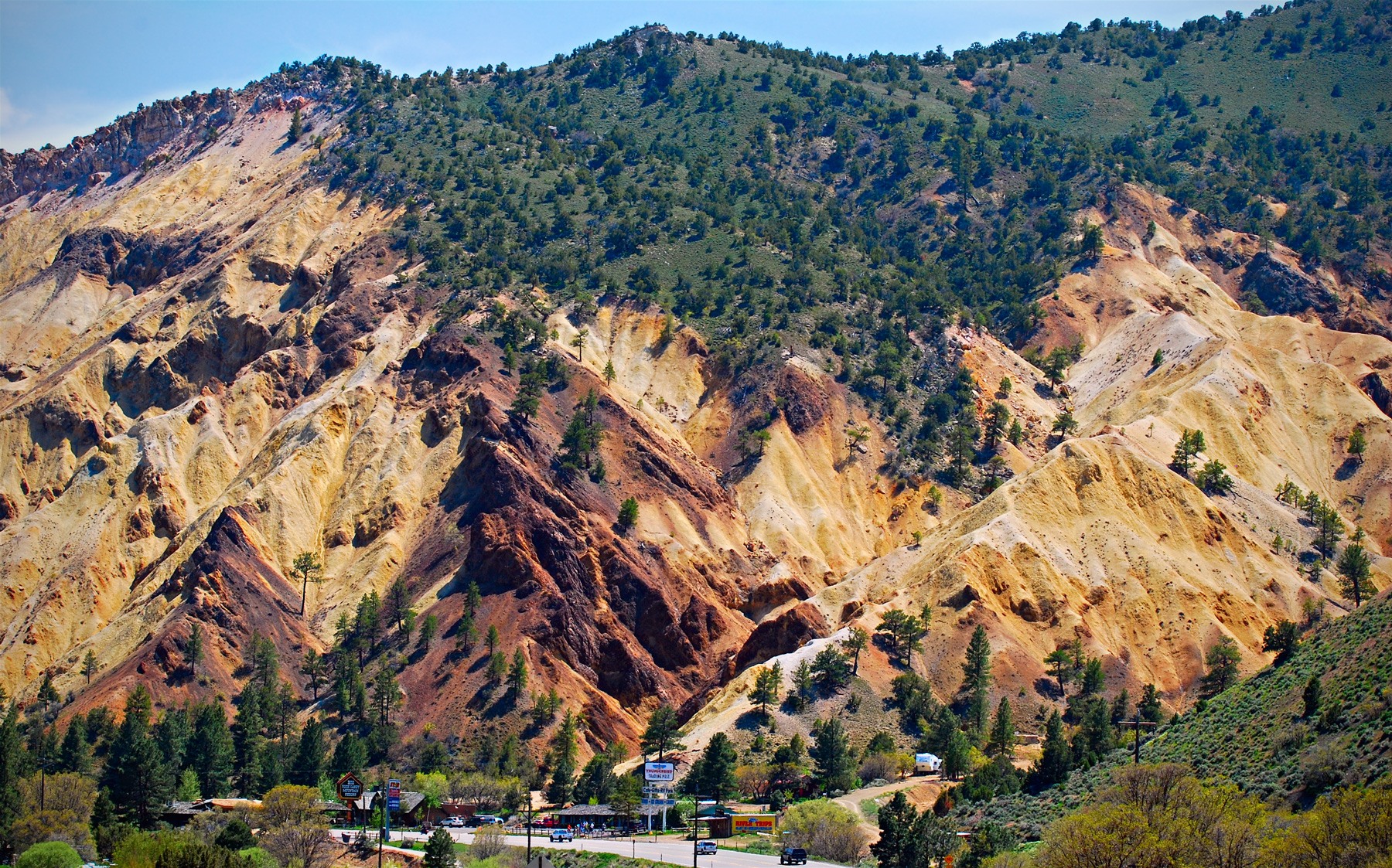
 Well, I didn't know there really was such a thing as the Big Rock Candy Mountain, but here it is, rising above a resort with the same name along Highway 89 near Marysvale, Utah.
Volcanic explosions, followed by magmatic intrusions, followed by twenty-odd-million years of erosion and hot-springs-type chemical interactions have streaked the mountain with colorful mineral deposits. The reddish rocks contain iron-based minerals, including hematite and pyrite, while the whitish rocks contain potassium-based minerals, notably including kaolinite, a valuable white clay used to make paper glossy for magazines or photos.
The mineralization of Big Rock Candy Mountain acidifies runoff water, leaving the soil here relatively inhospitable to vegetation. Nonetheless, ponderosa pine are hanging on, especially near the ridgetop.
It's hard to imagine that in the 1930s there would have been anything about this part of the world that was hospitable to hoboes, either. No lemonade springs, no lakes of stew and whiskey too, no cigarette trees, nothing but more of the longing and aching that inspired Harry McClintock's song.
mountains
music
geology
Utah
Harry McClintock
mineral
Great Depression
Marysvale
hoboes
Burl Ives
(Photo credit: Ray Boren)
Sep 27, 2011
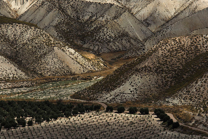 Polish photographer Marcin Sacha has recently added the landscapes of Andalusia, Spain, to the range of scenes in his portfolio.
landscape
mountains
birdseye view
Spain
Andalusia
(Image credit: Marcin Sacha)
Jan 26, 2012
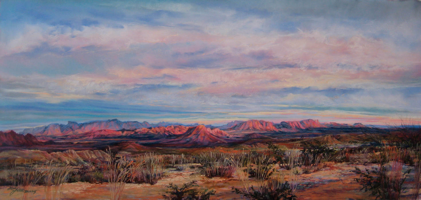
 A Terlingua Sunset, by Lindy Cook Severns.
Terlingua encompasses thousands of acres of sparsely settled desert country along the Rio Grande in far west Texas, between Big Bend National Park and Big Bend State Park. There's cinnabar ore in those mountains, enough to support profitable mercury mines a hundred years ago, but nowadays the only mercury miners left are the ones in the Terlingua cemetery.
Many of today's Terlinguans live more or less off the grid; land is inexpensive, but bringing in electricity costs something like $10,000 per pole. The landowners are only lightly supervised by local government, but like big-city condo owners they are regulated by an owners' association, which employs a full-time staff to maintain community wells and roads and to operate an income-generating campground and lodge.
Vanessa Boyd, director of the landowners' organization, which is known as Terlingua Ranch, is a musician as well as a land manager. She just released a new album last week, which incorporates songs she composed in preparation for a 2010 concert tour to Nepal.
Texas
landscape
mountains
sunset
desert
ghost town
Vanessa Boyd
Big Bend
Rio Grande
mercury mining
(Image credit: Lindy Cook Severns)
Feb 10, 2012
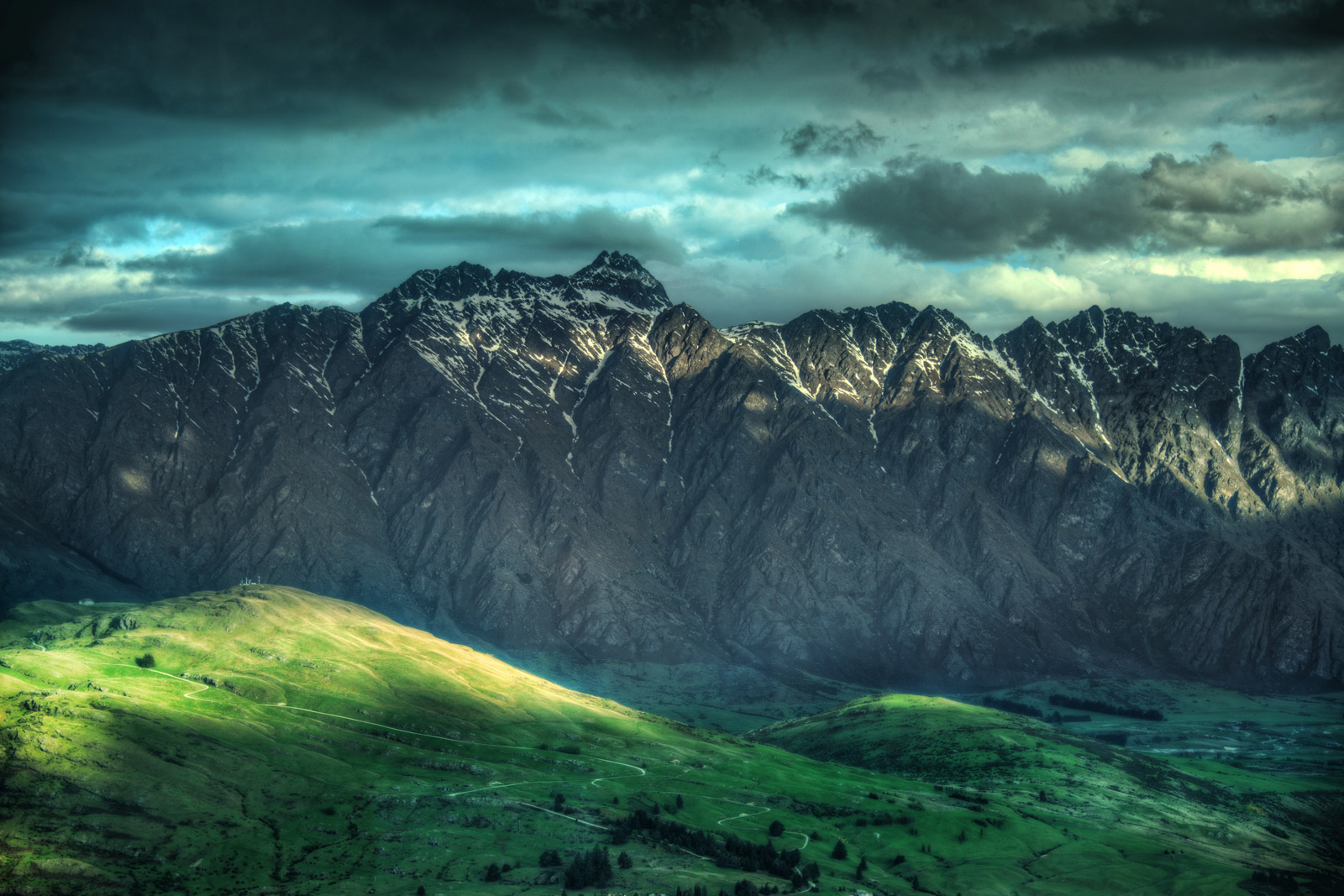
 Not every mountain range could live up to the name The Remarkables, but these peaks on the South Island of New Zealand do a handsome job of it.
landscape
New Zealand
mountains
(Image credit: Trey Ratliffe)
Mar 31, 2012
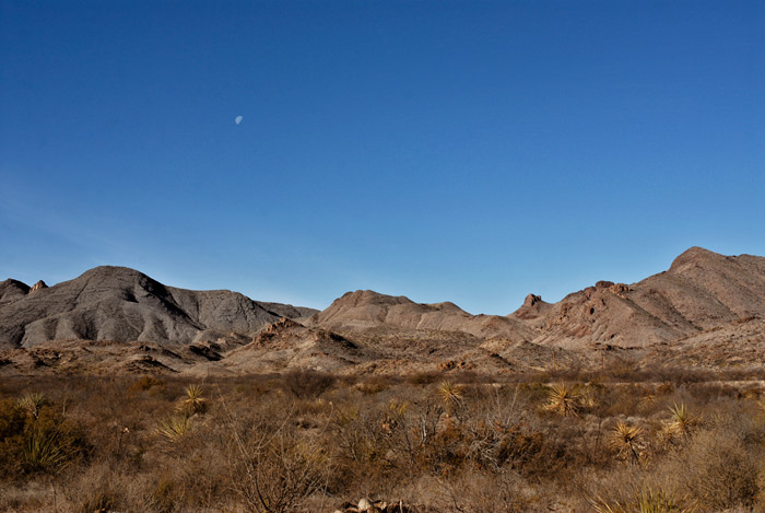 The mountain moonscape of Terlingua, Texas, illuminated (ever so slightly) by the moon at noon.
Texas
landscape
mountains
desert
Terlingua
moon
(Image credit: Ted Stein)
Apr 26, 2012
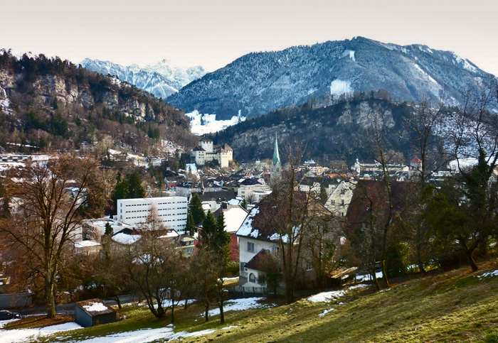 For all the marbles: In this picture, we are looking at (virtually the entire) capital city of which European nation?
29 April update: Vaduz, Liechtenstein. We had three winners.
landscape
Europe
mountains
cityscape
castle
(h/t: Katrin Maldre)
(Image credit: Jason Wight)
May 15, 2012
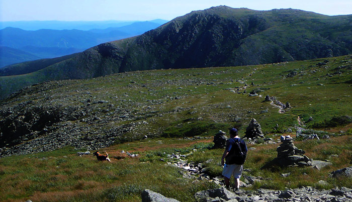 Of the various dogs who've come to live with us over the years, only one–this one–was named Professor Brophy. We called her Professor for short. Professor was a dumpy-looking brown dog from the pound with big jaws and an unfortunate personality, to put it mildly; she snarled at people when they tried to come in the house and then snapped at their heels when they tried to leave.
You may ask why we invited such a beast into the family. Well, obviously, Professor was smart enough not to treat us as rudely as she treated outsiders. Maybe she did what she did because she cared for us and felt she had to protect us from dangerous intruders. Or maybe she really despised us right along with everybody else but realized she'd better suck up to us.
Whatever was going on in that professorial little dog brain, it kept us hopeful for a while. And mixed in with the trying times were some very, very nice days with Professor–such as this perfect summer afternoon up above treeline on Mount Washington. That's Professor Stein following along behind as Professor Brophy breaks trail; a good time was had by both.
Mt. Washington
landscape
dog
mountains
New Hampshire
Norman
Professor Brophy
Dec 15, 2012
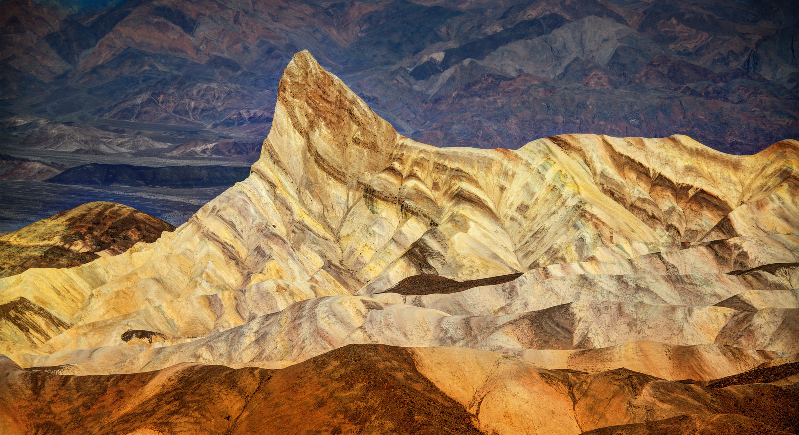
 The Painted Mountains in Death Valley, California.
landscape
mountains
rocks
desert
California
Death Valley
Painted Mountains
(Image credit: Trey Ratcliff)
May 1, 2013
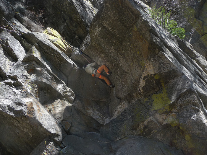
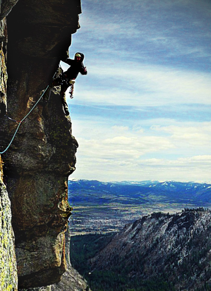 Blodgett Canyon, in the Bitterroot Mountains of western Montana, is a Yosemite-esque sort of place, flanked on the north by sheer granite walls of towering spires that are absolutely irresistible to rock climbers with ropes and stuff.
Our boy Hank climbed Blodgett's 600-foot Shoshone peak twice this spring; the first time, a sudden rainstorm forced a rapid rappelling retreat that left a lot of climbing gear stuck in cracks on the rockface. The second climb, pictured here, was a successful gear-retrieval mission–and also a sun-kissed flirtation with warm spring skies.
landscape
mountains
rock climbing
Montana
Shoshone
Bitterroots
Blodgett Canyon
(Image credit: Hank Stein)
Jun 21, 2013
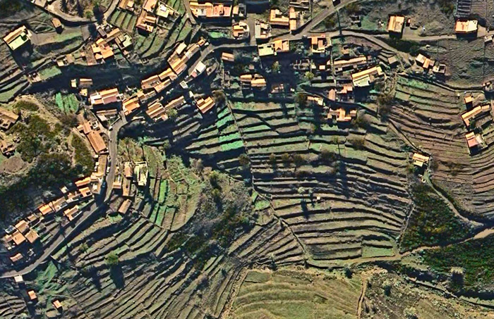 Aerial view of terraced farmland surrounding a village in the Valle Gran Rey on Isla de la Gomera, one of Spain's Canary Islands off the coast of Morocco.
landscape
mountains
aerial imagery
Canary Islands
Oct 10, 2013
Apple hired National Geographic photographer Jim Richardson to go up into the Scottish highlands and shoot some scenery with an iphone camera.
landscape
mountains
cell phone camera
lake
Scotland
(Image credit: Jim Richardson)
Oct 29, 2013
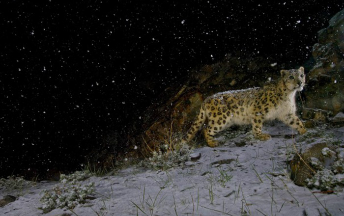 In Hemis National Park in the extreme north of India, near the Tibetan border.
animal
mountains
night
India
Kashmir
(Image credit: National Geographic)
Nov 27, 2013
 The cold and the storms both showed up in Philadelphia this week, but somehow the effect we see here in a high mountain valley in the Tyrolean Alps is a little more dramatic and astonishing than it is out on the streets and sidewalks of Brotherly Love. Pretty much all we've got in town right now are slashing rains and chill.
landscape
mountains
winter
Italy
snow
sky
clouds
storm
South Tyrol
Feb 21, 2014
 When we returned from New Zealand late last year, we were particularly eager to share pictures of the really interesting, stretch-of-the-imagination stuff we'd encountered there: car-eating parrots, cardboard cathedrals, a parkour professor, and of course an awesome ukelele wedding.
We'd set out for New Zealand hoping for this sort of serendipity but knowing for sure we'd see scenery: mountains, waterfalls, forests of hobbity vegetation, cities with flowers, beaches and cliffs, and, of course of course, sheep. We lucked out with all of that as well.
And needless to say, we got pictures.
So for the next little while, we'll share some shots of the real New Zealand, beginning tomorrow with The Silver Fern
New Zealand
mountains
clouds
Milford Sound
waterfalls
scenery
(Image credit: Little Fuji)
Mar 14, 2014
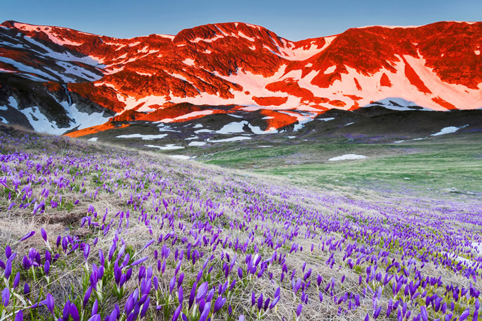 This year in Philadelphia, spring is coming ridiculously late, but it's coming. One sign that gives us high confidence in spring's imminence involves the tips of the crocus stalks, which are just now beginning to poke their way up out of the cold, wet ground. They'll be blooming soon, maybe within the week.
In the high meadows of Bulgaria's Rila Mountains, tallest peaks in the Balkan Peninsula (2925 m), spring always comes late, and crocuses don't bloom till the middle of June. This picture was taken two springs ago on June 19, 2012.
To catch the bright red glow on the ridge rocks, photographer Evgeni Dinev had to climb up here the day before, hauling up a tent, tripod, and all his camera gear. He snapped the shot at sunrise.
landscape
mountains
flowers
spring
Bulgaria
sunrise
Balkans
crocus
Rila Mountain
(Image credit: Evgeni Dinev)
Mar 28, 2014
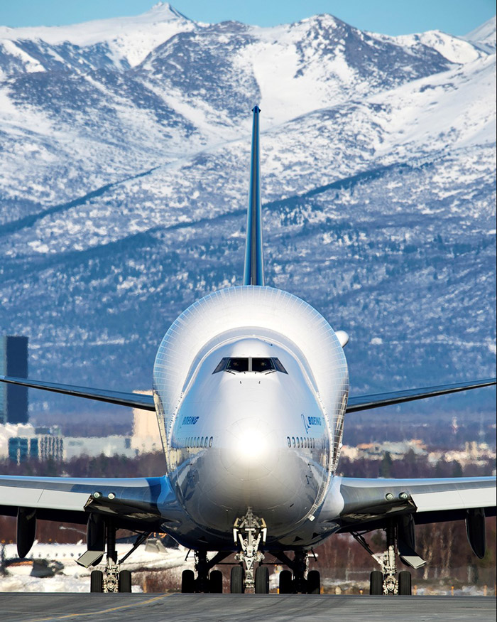 The Dreamlifter, world's largest cargo plane, stops off regularly in Anchorage, Alaska, en route from parts suppliers in Japan to a Boeing aircraft assembly plant in Everett, Washington.
Some of the parts that travel by Dreamlifter are large modular sections of Boeing 787 jetliners, known as Dreamliners. The sub-assemblies, much too large for other cargo planes, used to be transported by ship, which could take thirty days or more and sometimes led to delays in final assembly.
In 2005, four 747 passenger planes were remodeled to fly as cargo planes carrying the sub-assemblies, which are loaded through a wide hatch at the stern. Other cargo planes can carry more weight, but none can match the four puffed-up Dreamlifters for sheer volume of storage space.
landscape
mountains
Alaska
winter
airplane
Anchorage
747
Dreamlifter
787
Boeing
(Image credit: nikonmojo)
Apr 11, 2014
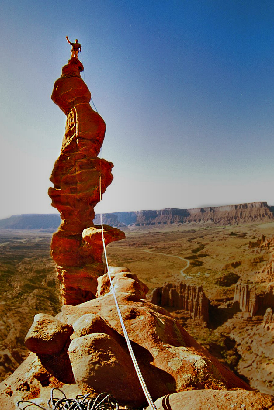
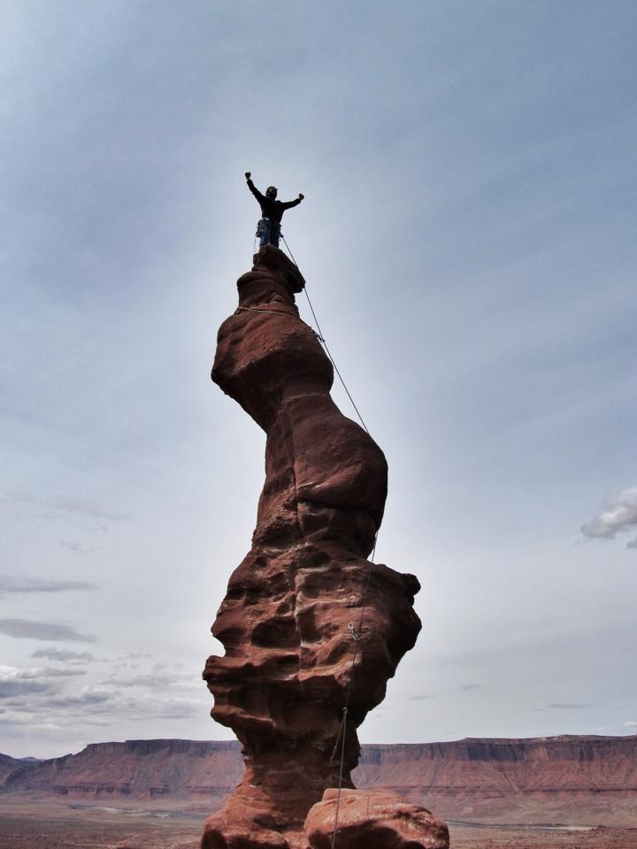
 This spring-break picture of Hank at the summit of the Stolen Chimney, a corkscrew spire atop the Ancient Art rockwall near Moab, Utah, has already been on Facebook, where it attracted a few comments. The award for Best Comment goes to Hank's Uncle Bob: "Get down from there this instant!"
mountains
tower
rock
Hank
Utah
climbing
Moab
pose
spire
Apr 12, 2014
 Looks like yesterday's g'mornin was one silly mess: wrong boy, and even wrong uncle.
This picture shows the real Hank Stein atop the twisted chimney at Ancient Art near Moab, Utah. Yesterday's picture was of some other somebody.
And the uncle who gave him a sort of shout out on Facebook–"Get down from there this instant!" That was his Uncle Rich. Yesterday's posting attributed those immortal words to some other uncle.
Apologies all around.
mountains
rocks
desert
Hank
Utah
Uncle Rich
climbing
Moab
Ancient Art
Sep 10, 2014
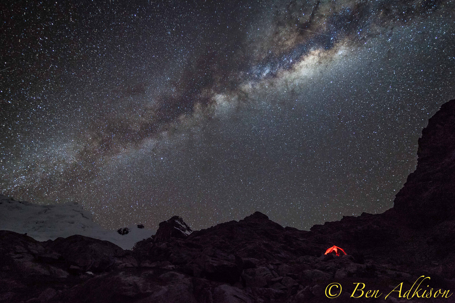
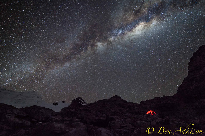 Last month, Hank joined a group of Montanans climbing in the Andes, summiting above 18,000 feet in the middle of the Peruvian winter. They were closer to the Milky Way up there.
landscape
mountains
night
rocks
Hank
stars
night sky
Andes
Huaraz
Milky Way
Peru
(Image credit: Ben Adkison)
Mar 1, 2015
 Up in Tedland, high on the mountain above the Cacapon River, to get warm at all, you have to get warm twice. Or else wait till June and get all the warm you want, and then some.
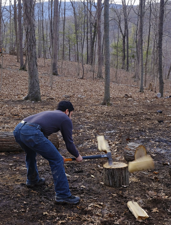
mountains
West Virginia
Ted
work
woods
Great Cacapon
(Image credit: Fuji T)
May 23, 2015
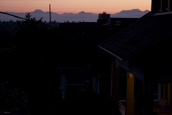 Night comes to NE 78th Street in Seattle.
A few stray power lines hint at the electrical substation down the hill but don't even come close to hiding the Olympic Mountains on the horizon.
landscape
mountains
night
sunset
streetscape
Seattle
(Image credit: Fuji T)
Jan 11, 2018
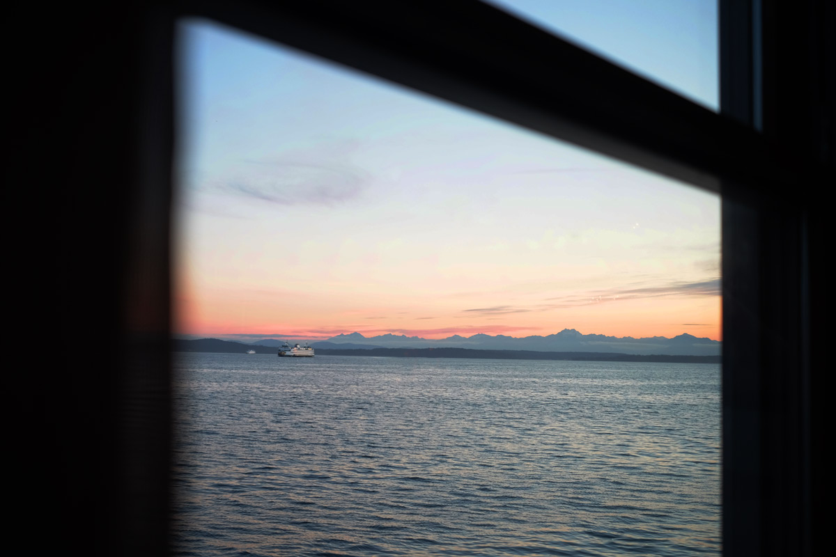
 The Bainbridge Island ferry and the Olympic Mountains at sunset, as seen across Elliott Bay from the bar at Pier 67 near downtown Seattle.
landscape
mountains
sunset
Puget Sound
Seattle
ferry
(Image credit: Fuji T)