Ukraine train
Dec 3, 2009
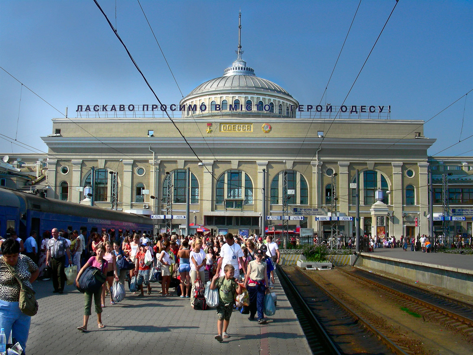
Dutch photographer Leo Koolhaven took this shot at the train station in Odessa.
Dec 3, 2009
Dutch photographer Leo Koolhaven took this shot at the train station in Odessa.
Jan 10, 2010
The Grand Trunk Line went bankrupt in 1920. Cost overruns on its expansion to the West Coast stressed the company, and its route planning out west proved unfortunate, too far north to compete with the fledgling Canadian National Railroad, which eventually absorbed it. The Grand Trunk's U.S. lines were assigned to a holding company that used the Grand Trunk name, but they too declined and faded in the mid-twentieth century along with the railroad industry in general.
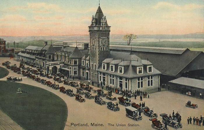
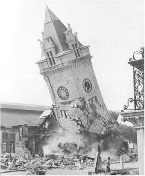
The Grand Trunk station in Portland, on India Street near the waterfront, was demolished in 1948. These pictures actually show a different Portland train station, Union Station on Congress Street near St. John Street, which handled southbound passengers and freight. Union Station opened in 1911 and was demolished in the1960s to make way for the I-295 highway.
Portland lost an elegant building that day--the current Amtrak station is basically just a corner of the bus station lobby--but by all accounts, the destruction awakened people to the importance of historic preservation. And though it couldn't have been foreseen in the 1960s, when urban renewal was thought to lead to future glory for America's cities, Portland's old buildings and cobblestone streets have turned out to be what saved this town--people have learned to make money off of "quaint."
Jan 11, 2010
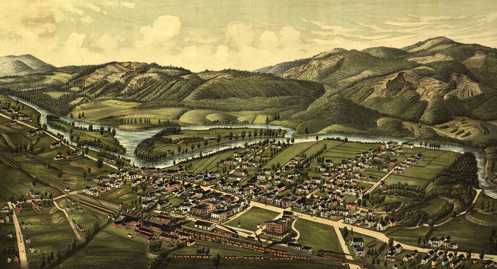
When they built the Grand Trunk line from Portland to Montreal in the early 1850s, they had to figure out a way over or around the White Mountains in New Hampshire. They ran the tracks up the Androscoggin River valley past the tiny village of Gorham, just eight miles north of 6,200-foot Mount Washington. Gorham became the railroad maintenance and service center, and this late-nineteenth-century birdseye view of Gorham shows the extensive railroad yards developed there.
Anyone who has been to Gorham, however, will notice something a little odd about this image of the place. The mountains in the background look low and unprepossessing, just some handsome, rolling topography off in the distance. Actually, they loom crazy big over the town, with Mount Washington in particular filling the sky and dominating the view almost like an Alp. Gorham is less than 800 feet above sea level; the peak of Mount Washington is more than a mile higher. Perhaps the artist (and/or his patrons in town) feared that big mountains might scare people away from Gorham. Gentle country would look more hospitable.
But the railroad that created Gorham eventually brought tourists to the hills, and today the town survives as a jumping-off point for vacationers in the White Mountains. An artist publishing a twenty-first-century birdseye view of the town would probably want to emphasize the mountains, maybe even drawing them bigger and steeper and closer than they really are. Wild, dramatic country is what the people want nowadays.
Trains don't stop here any more, but there is a railroad museum.
Nov 17, 2010
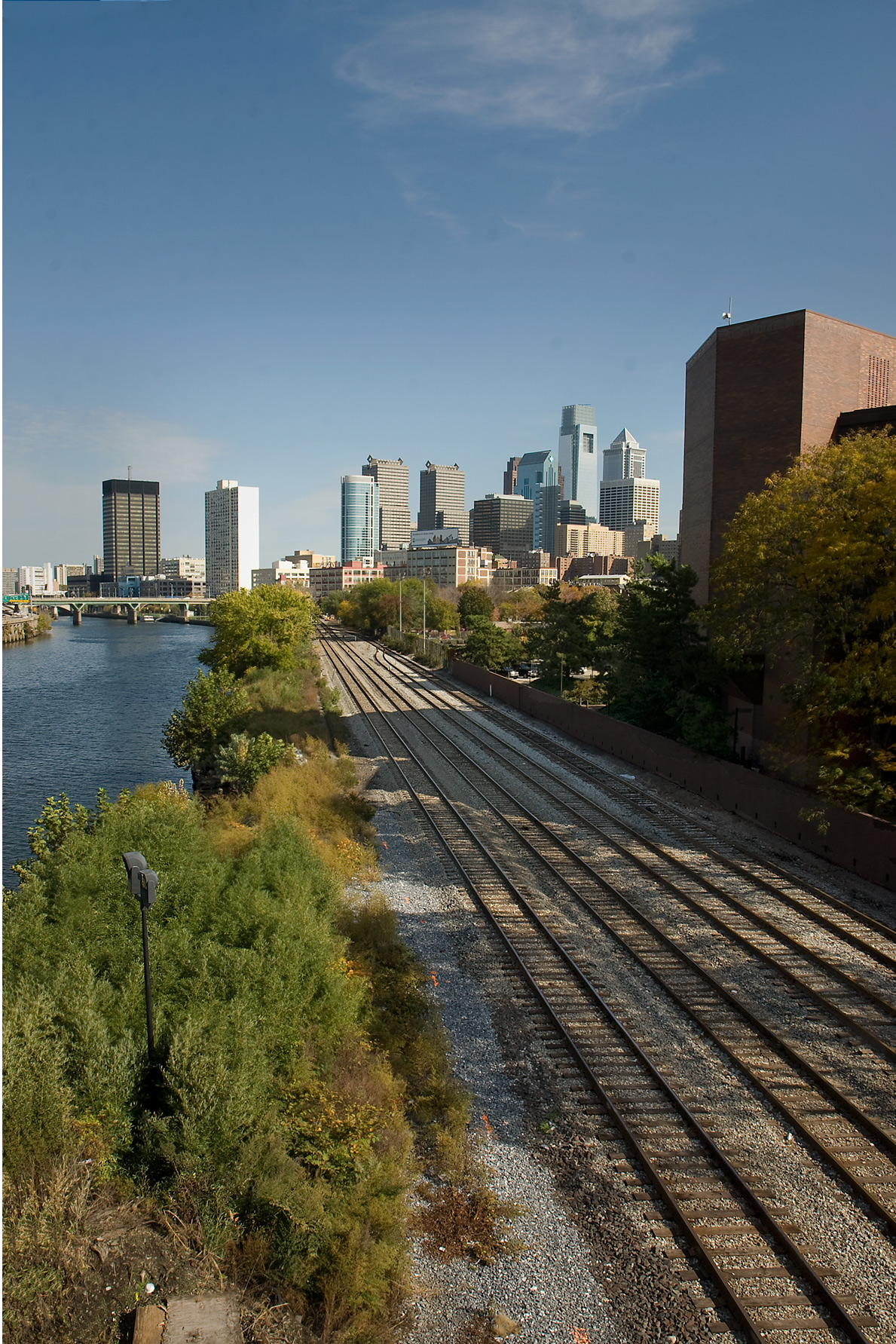
A couple of weeks ago, before the new bridge opened, I snuck out onto it while the workmen were at lunch. When I looked upstream along the Schuylkill, I saw railroad tracks cutting straight through to Center City and beyond, past all those skyscrapers ssoaking up the sun.
Aug 23, 2011
 One evening in 1910, this man got off the train at the station in Ann Arbor, Michigan, picked up his coat and his briefcase, put on his hat, and headed up the hill toward home. It is possible, of course that what I referred to as the man's briefcase may actually be a salesman's sample case or a traveler's overnight case–but overall, that's my story and I'm sticking to it.
Jan 3, 2013
 Heading south across the James River from downtown Richmond, Virginia, the half-mile-long Manchester Bridge was completed in 1972 to replace a much lower span that was repeatedly damaged by floods.
Barely visible in the distance, near the righthand edge of this picture, are the brick piers of a former railroad bridge that was repeatedly ruined by fire.
The current Manchester Bridge includes a wide pedestrian walkway separating southbound and northbound traffic. This was required by law; in 1920, when the city of Richmond annexed what was then the city of Manchester across the river, the merger documents provided for a free pedestrian bridge across the James, in perpetuity. Until then, the only bridge charged pedestrians a toll, which was so aggravating to residents of Manchester that they voted to dissolve their city government in return for a promise of a toll-free bridge.
The ruined railroad bridge burned for the first time during the Civil War; the Confederates destroyed it–the night they drove old Dixie down–in anticipation of the fall of Richmond. It was rebuilt after the war but burned again in 1882.
Feb 25, 2013
 Yesterday, we caught the view from New York City's High Line rails-to-trails boardwalk, a park that winds along the western edge of lower Manhattan, thirty feet up in the sky.
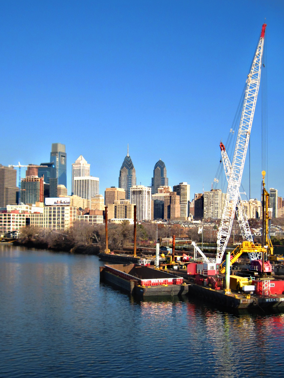
Today's glimpse of a tracks-to-boardwalk project is in Philadelphia, alongside the Schuylkill River, where barge-mounted heavy equipment is currently driving pilings into the riverbed for a boardwalk that will soar out over the water to extend an existing twenty-plus-mile asphalt biking and walking path.
The asphalt path follows an abandoned railroad bed downriver from Valley Forge past Fairmount Park and the Philadelphia Art Museum and on into Center City. But at Locust Street, the trail ends abruptly, crowded off the riverbank by half a dozen railroad lines that are definitely not-yet-abandoned.
The plan is to extend the path southward by snaking it out over the river as a boardwalk with observation platforms and maybe some fishing decks. (Although the Schuylkill is a bit shy of what you'd call a pristine river, there are definitely fish swimming in it, and they are catchable, if not eatable.)
After about half a mile over water, the new boardwalk will pass under the South Street Bridge and then curve back onto dry land for the remainder of its route. It will terminate in southwest Philly at Bartram's Gardens, an eighteenth-century homestead where America's earliest botanists planted the New World's first collection of botanical curiosities.
Planned completion date for the boardwalk is . . . early 2013, or so it is written. Whenever.
Nov 7, 2014
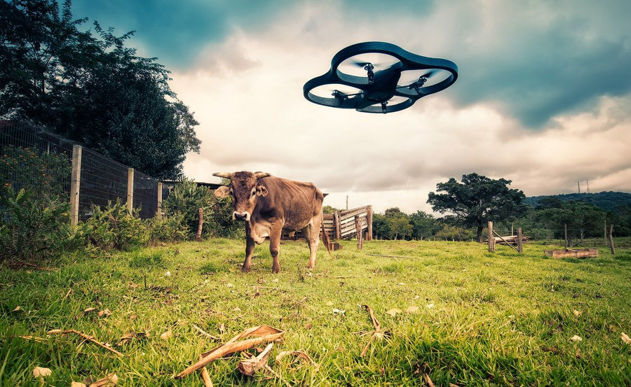
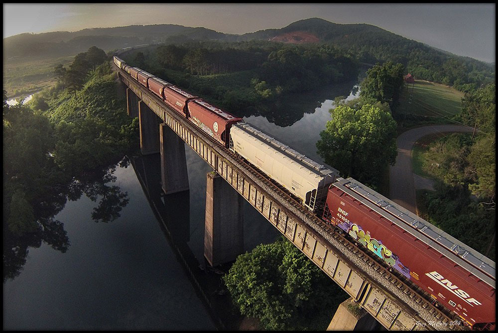 All the cool kidz nowadays–all the cool kidz who have a little too much money–or is too much money one of the requirements for cool kidz status?–anyways, what they're playing with these days is the latest and greatest in technology for drone photography.
Little plastic remote-controlled flying saucers carry cameras aloft and point the lenses back down at us. Sometimes the things crash–for example, onto the balcony of an apartment on a high floor of a New York skyscraper–but sometimes they capture astonishing views of life here on the surface of earth.
To get the shot above, Greg McCary flew a drone up over the hills and rivers of Bartow County, Georgia, northwest of Atlanta. Below, Mauricio Lima's venture into drone photography attracted the attention of a wary neighbor.