Hole in the Clouds
Feb 8, 2010

In an impact crater inside a volcanic crater high on a Martian mountaintop, ancient bedrock is exposed. The high elevation and crater ramparts keep out the red dust that swirls over most of the planet. This picture of the rocks there was captured by infrared sensors in an orbiting telescope, part of a NASA probe known as HiRISE.
The rocks are more than 3 billion years old, among the oldest known on the planet. The infrared sensors detected a variety of hydrated minerals, evidence that this place was once under water, for a long time. Some of the minerals detected contain chloride, as in table salt.
There is still H2O on Mars--pictures taken early in the morning often show frost--but the Martian atmosphere is so thin nowadays that water is unstable in its liquid form.
bedrock
space
Mars
(Image credit: NASA HiRISE)
May 13, 2011
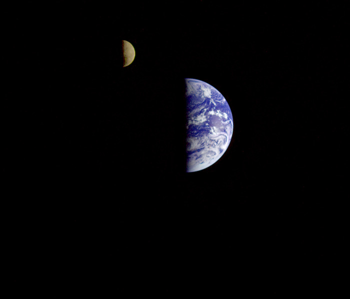
 In 1977, the Voyager space probe shot this picture of the earth and moon together. It is believed to be the first snapshot that captures both bodies in the same frame.
birdseye view
space
planetary landscape
Voyager
(Image credit: NASA)
Jul 4, 2013
 It's not hard to remember the excitement of those days fifty or so years ago when the teacher would tell us to pick up our chairs and form a line at the classroom door. We would all carry our chairs down the hall from the classroom to the school's "all-purpose room," where we could sit facing a big black-and-white TV set at the front of the room to watch those guys at NASA choreograph a countdown and a liftoff and all the other amazements that were part of America's new space program.
Today, it's hard to figure out exactly what NASA is up to in outer space. There seem to still be astronauts, but it appears that we now rely on the Russians to do that whole countdown-liftoff thing. Americans mostly look at pictures from faraway cameras.
From Ted in Washington, D.C., comes this photo of a sign of the times for NASA and perhaps the grand American dream: a NASA message held in place by a bicycle chain and a couple of sacks of Quikrete. The NASA folks may not be zipping around in space these days as much as they used to, but their public website is freshly launched, or rather relaunched on a freshened, open-source, space-age sort of platform, saving us taxpayers millions in licensing and maintenance costs. For this, we can thank our Ted and his Inner File, the little company that could.
Do people still have hot dogs and watermelon for the Fourth? Hope so.
streetscape
space
parking
shuttle
NASA
(h/t: Ted Stein)
Oct 13, 2013
 Well, of course now that our American space program is shut down because of hateful people in the House of Representatives, the brand new Landsat 8 satellite that you and I paid for, which had just started phoning in dramatic new views of our planet, has gone dark. But fortunately, many other countries have legislatures that don't seem to go quite so insane over efforts to help people get medical care, and so new earth imagery from foreign satellites is still available to us.
This is the view from Kompsat 2, a Korean satellite, as it crossed southern Africa above the Namib Desert on the morning of October 5. What appears to be blue water is actually an ancient riverbed, almost entirely dry for millions of years; the white streaks are bone-dry salt flats.
Click to zoom in and see roads in the riverbed and some black dots that represent the only vegetation for hundreds of square miles; These desert shrubs survive on groundwater, of which there is hardly any; such as is there is, however, collects deep underneath the riverbed, below the gullies where water does trickle on those rare occasions when it rains here. Annual precipitation is less than half an inch on average, though it is supplemented a bit by coastal fog.
Note the short spur leading off the main road near the middle of the scene and ending at the base of a dune. This is the route to a parking lot at Dune 45, a thousand-foot high sand dune popular with tourists.
birdseye view
Namibia
desert
space
remote sensing
Africa
satellite
Korea
(Image credit: Kompsat 2 via European Space Agency)


